

Early Morning Update
The last few hours have been getting interesting across the area. The temperature have been slowly dropping in Central Alabama and we have seen an uptick in the precip rates.
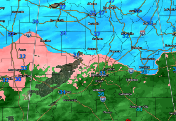
Accumulating snows ongoing across the Tennessee Valley from Florence to Huntsville.
Between Birmingham and Huntsville, numerous reports of icing and slick spot on roadways along U.S. 278 from Hamilton, through Haleyville and Cullman. Bridge and overpass icing along Interstates 65 in Cullman County as well as Interstate 22 in Marion County.
In the Birmingham area, the temperature the last hour has been 33 and there are reports of some light icing developing in higher elevations as well as elevated surfaces. Just north of the downtown, sleet and freezing rain being reported. In more rural areas of Jefferson County, reports of icing on trees and outside yard furniture too.
To our west in Mississippi, similar conditions along the U.S. 82 corridor. Reports from Starkville of an ice glaze on cars on the campus of MSU. MDOT is also reporting widespread icing on roadways throughout Central Mississippi.
Road conditions will only get worse the rest of this morning. There are a lot of slick spots developing and as the temps continues to slowly fall the next few hours, we will transition to a freezing rain and significant icing event for the Interstate 20 corridor.
Category: Alabama's Weather, Winter Weather
About the Author (Author Profile)
Macon, Georgia Television Chief Meteorologist, Birmingham native, and long time Contributor on AlabamaWX. Stormchaser. I did not choose Weather, it chose Me. College Football Fanatic. @Ryan_StinnetSubscribe
If you enjoyed this article, subscribe to receive more just like it.


