

Watching to the West
As we wait on round two of our wintry precip to arrive later this evening, it is interesting to see the trends to our west, as they could be impacting Alabama later tonight. The next phase of this winter storm is developing and we are beginning to see a precip shield expand in coverage as it heads east. It will be moving into Alabama the next few hours.
First off lets talk current conditions across the state. Highs did not climb as high today as model data suggested. There has been a north wind blowing across a snow pack just to our north. The warmest Birmingham has made it today has been 37. Models predicted lower 40s for today. This means that it will be easier to reach the freezing mark later tonight.
We are seeing moisture increasing across the area as the radar image is beginning to fill in. We will see these showers spread across Alabama through the overnight hours. However, we are watching an area of low pressure in the western Gulf of Mexico. It will be moving northeast overnight and is expected to move onshore during the day tomorrow near Pensacola, Florida. For a classic winter storm for Alabama, a low lifting northeast out of the Gulf is almost a necessity and that is what we shall have tomorrow. As the low pumps moisture north and slides to our east, it will pull south additional cold air. With the over running precip, there will be some significant accumulations across portions of the Southeast, and I think this could be a possibility for portions of eastern Alabama.
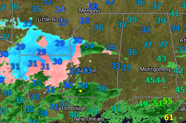
Now to our friends to the west in Mississippi, Louisiana, and Arkansas. Temperatures throughout this area continue to be at or below the freezing mark. The NWS in Jackson has extended their winter weather alerts further south. They have expressed concern today of a growing threat of a significant freezing rain event developing over some of their counties since temperatures did not get as warm as expected today. This seem likely to begin to happen in the next few hours.
Storm reports from the NWS Shreveport show freezing rain and sleet falling across northern Louisiana. Glazing on roadways is already occurring and travel conditions are becoming treacherous. Multiple cars have been reported sliding off I-20 in northern Louisiana. There are reports of ice coating trees and bridges through the area as well. The ASOS at Shreveport has reported over 0.25″ of icing the last hour with a temperature of 30F. Sleet is covering the ground, roads are slushy, and icicles are hanging from utility lines.l
As the precipitation moves into Alabama, similar conditions will develop where temperatures are at or below 32F. This most like area for this is shown on this graphic from the NWS:
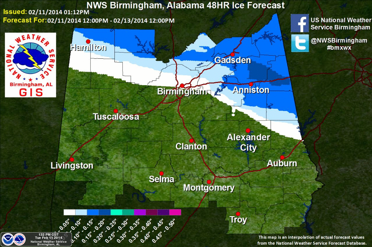
Now south of this icing forecast area, it should just be a cold rain. BUT, we caution everyone to check the latest conditions before making any travel decisions for late tonight or early tomorrow morning across the area.
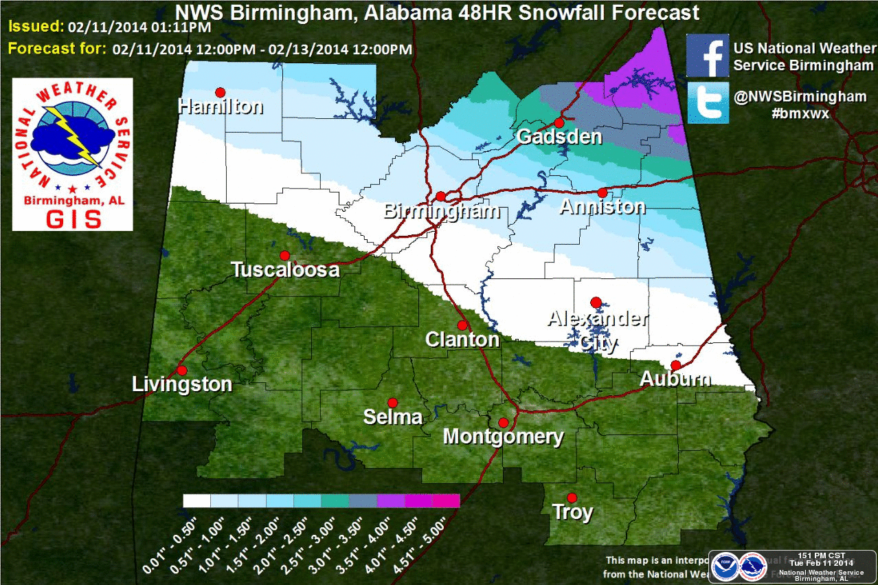
Once we get through this threat in the morning, snow will be the problem tomorrow afternoon and tomorrow night as colder air in pulled into Alabama on the back side of the low. The GFS and the European are in excellent agreement that there will be accumulating snows possibly as far south as a line from Millport to Lake View to Thorsby to Eclectic and Auburn. More travel problems can be expected tomorrow night and Thursday morning in areas where roads become snow covered.
Here is the NWS snowfall accumulation forecast graphic:
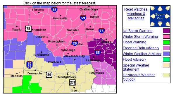
A reminder of the alerts across Alabama can be seen below. As the event unfold, certainly counties could be added to the warnings and advisories. This is a very tricky forecast as the models are not handling this event very well. I urge people to pay attention and check conditions in the morning The could be some freezing rain ongoing along the Interstate 20 corridor tonight and make no plans about traveling around tomorrow as this will be a prolonged winter weather event. Travel conditions are only going to deteriorate overnight and become treacherous. There will likely be some surprises along the way tonight and into tomorrow. Continue to prepare for the worst, and hope for the best.
Category: Alabama's Weather, Winter Weather
About the Author (Author Profile)
Macon, Georgia Television Chief Meteorologist, Birmingham native, and long time Contributor on AlabamaWX. Stormchaser. I did not choose Weather, it chose Me. College Football Fanatic. @Ryan_StinnetSubscribe
If you enjoyed this article, subscribe to receive more just like it.


