

Rainy Valentine’s Night
A rainy Valentine’s night is in progress across Central Alabama as a strong upper level trough and cold front approach the state.
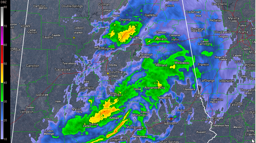
A shield of rain and embedded thunder is pushing across the middle of the state. At this hour, it is mainly east of I-59.
An upper level disturbance appears to be passing just south of Birmingham, showing a little bit of spin as it lopes east southeast.
There were a few flashes of lightning across the area, and even some pea sized hail in Marion.
The heaviest rain has fallen in an arc from Tuscaloosa County up through Fayette, Walker, western and northern Jefferson, Blount and St. Clair counties. Radar estimates indicated that one half to one inch amounts were common, with some amounts in excess of that. Areas near I-20 in St. Clair County between Moody and Pell City picked up between one and two inches.
The rainfall total at the Birmingham Airport was approaching one half inch at 8:45.
Our cold front has passed Columbus MS and Muscle Shoals. Temperatures fall quickly back into the 40s behind the front.
A second front has passed Memphis. Temperatures are in the 30s behind it. So by morning, readings across the area will range from the middle 20s over the Northwest to the lower 30s from Clanton to Alex City. Expect upper 20s in the I-59 corridor.
Tomorrow will feature clearing skies, but chilly temperatures in the upper 40s.
But take heart. highs on Sunday will rebound nicely into he lower 60s.
Category: Alabama's Weather
About the Author (Author Profile)
Bill Murray is the President of The Weather Factory. He is the site's official weather historian and a weekend forecaster. He also anchors the site's severe weather coverage. Bill Murray is the proud holder of National Weather Association Digital Seal #0001 @wxhistorianSubscribe
If you enjoyed this article, subscribe to receive more just like it.


