

Thundersleet!
Thundersleet in Collierville near Memphis. I think we have seen it all this winter.
Operation Wintry Precip Watch is on for tonight across North and North Central Alabama. Ryan Stinnett and I will be monitoring radars, surface observations, model data and reports throughout the night.
The good news is that we don’t expect any significant problems overnight, but there will be a brief changeover to a mix of precipitation during the early morning hours as colder air filters seeps southward into the state.
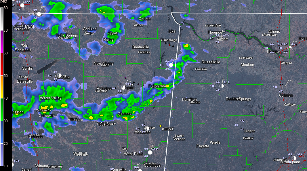
Overrunning is already occurring over Mississippi, producing some convective precipitation. A thunderstorm is reported with the showers at Oxford. Lightning is increasing from Booneville to Tupelo to Batesville.
Meanwhile, WTVA reports sleet with the showers in Northeast Mississippi near Booneville. At the nearby Tishomingo County Airport, it is 46F.
Ice pellets have also been reported at Tupelo and Oxford. Evaporational cooling dropped the temperature to 39F at Oxford. It was 50F at Tupelo.
Thundersleet is being reported in Collierville TN.
Especially dry air north of the Tennessee River will limit precipitation overnight. There will continue to be some sleet mixed in with the rain at the onset of the precipitation tonight, but it should change back to rain. Light rain will continue into the early morning hours with temperatures dropping into the 30s along and north of US-278 by midnight. Readings will drop to near or just above freezing north of a line from Carrollton to Hoover to Munford by 6-7 a.m.
Atmospheric temperature profiles will cool to the point that the rain will change to sleet or a little freezing rain by 3 a.m. near US-278. This trend will continue between 3 a.m. and sunrise down to that line from Carrollton to Munford. There could even be a few snowflakes mixed in.
In addition, we will have to watch parts of Clay, Randolph and Cleburne Counties between 6-9 a.m. for the possibility of a wintry mix of freezing rain, sleet and snow.
The good new is that precipitation amounts will be light, and the ground is warm. And temperature profiles favor sleet as the predominant type of freezing or frozen precip. So accumulations should not be a problem. But it doesn’t take much freezing rain to cause problems and a quick burst of sleet or snow can accumulate before the warm roads can melt it, so we will be watching for any surprises overnight.
And we urge you to check back through the night for developments and to get up a little early tomorrow to check the latest conditions. Just in case.
LATE REPORT
From Twitter, just saw a report of a meteor near Odenville.
Next up, locusts.
Category: Alabama's Weather, Winter Weather
About the Author (Author Profile)
Bill Murray is the President of The Weather Factory. He is the site's official weather historian and a weekend forecaster. He also anchors the site's severe weather coverage. Bill Murray is the proud holder of National Weather Association Digital Seal #0001 @wxhistorianSubscribe
If you enjoyed this article, subscribe to receive more just like it.


