

A Few Showers/Storms Tonight
RADAR CHECK: Very little on radar at mid-afternoon; only a few isolated showers over West Alabama not far from the Mississippi border. The rest of the state is rain-free with temperatures mostly in the upper 80s.
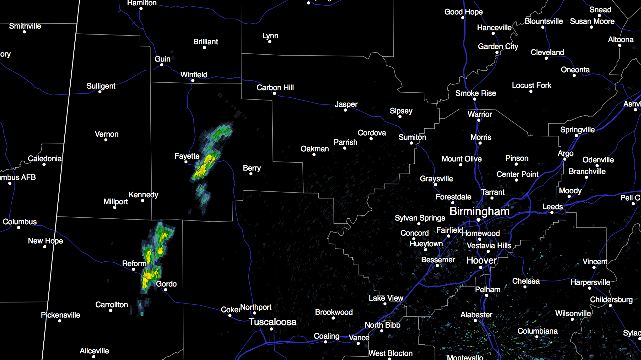
TONIGHT: A cold front will move into the state, pushing a band of showers and storms through. The storms should enter Northeast Alabama around midnight, with the highest chance of rain for the north-central counties between 1:00 and 6:00 a.m. SPC maintains a small “slight” risk of severe weather for a small part of Northwest Alabama, but we remain less than impressed with the severe weather threat with limited instability and shear, and weak wind fields. Rain amounts should be light and spotty, generally speaking.
TOMORROW: Showers will end pretty early in the day, and the sky becomes partly sunny as drier air moves into the northern half of the state. Showers by afternoon will be confined to the southern counties; we project a high in the low 80s.
WEDNESDAY: This still looks like the most pleasant day of the week, with ample sunshine and low humidity. The high will be close to 80 degrees Wednesday afternoon.
THURSDAY/FRIDAY: Moist air returns Thursday, and while we should begin the day with morning sunshine, we will mention the chance of scattered showers and thunderstorms by afternoon. Then, on Friday, showers and storms become more numerous as moist, tropical air covers the state. Showers or storms are possible at any hour Friday, but there will be breaks in the rain. We will have a hard time getting out of the 70s Friday due to clouds and showers.
THE ALABAMA WEEKEND: Moist air will stick around for Saturday and Sunday; we are getting into that time of the year when it gets harder and harder to get dry, continental air this far south. There will be a chance of showers and thunderstorms on both days, but it won’t be a “wash out” with a few intervals of sunshine possible. Severe storms are not expected, and the high will be in the low 80s, pretty close to average values for mid May in Alabama.
Not much change into the first part of next week… weather expected in early summer with warm humid days and the risk of a few scattered showers and storms. No sign of any organized severe weather threat around here for at least the next 10 days.
GULF COAST WEATHER: We will forecast about 6 to 8 hours of sunshine along the coast from Panama City west to Gulf Shores each day through the weekend with the daily risk of scattered showers and thunderstorms. Highs will be close to 80 on the immediate coast, with mid to upper 80s inland. Sea water temperatures are in the mid to upper 70s.
WEATHER BRAINS: Don’t forget you can listen to our weekly 90 minute netcast anytime on the web, or on iTunes. This is the show all about weather featuring many familiar voices, including our meteorologists here at ABC 33/40. We will produce this week’s show at 8:30 CT… you can watch it on “James Spann 24/7” on cable systems around the state, or on the web here.
CONNECT: You can find me on all of the major social networks…
Facebook
Twitter
Google Plus
Instagram
Look for the next Weather Xtreme video here by 7:00 a.m. tomorrow…
Category: Alabama's Weather
About the Author (Author Profile)
James Spann is one of the most recognized and trusted television meteorologists in the industry. He holds the AMS CCM designation and television seals from the AMS and NWA. He is a past winner of the Broadcast Meteorologist of the Year from both professional organizations.Subscribe
If you enjoyed this article, subscribe to receive more just like it.


