

Rain/Storms Return To Alabama Friday
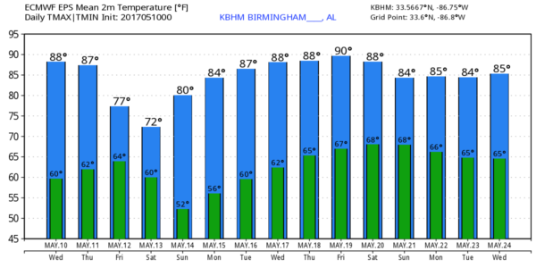
SUMMER-LIKE WEATHER CONTINUES THROUGH TOMORROW: On the maps this morning there is a deep upper low over the Southwest U.S… and around here we have a downstream ridge in place. That upper ridge will mean dry and very warm weather continuing today and tomorrow. With a good supply of sunshine both days, we project afternoon highs in the 87-90 degree range, which is 7 to 10 degrees above average for mid-May in Alabama.
WET WEATHER RETURNS FRIDAY: The upper low will lift out, and bring our next chance of showers and storms at the end of the week. We do note SPC has put parts of the state in a “marginal risk” of severe thunderstorms…
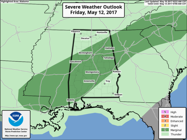
The high resolution NAM does show some fairly robust instability by Friday afternoon (surface based CAPE values rising to around 3,000 j/kg over West Alabama), but wind fields still look fairly weak, and the overall severe weather threat is fairly low. But, understand a few storms Friday afternoon and evening could produce small hail and strong, gusty winds.
While we can’t totally rule out a shower Friday morning, it still looks like the main window for showers and thunderstorms will come from about 12:00 noon Friday through 12:00 midnight Friday night. It won’t rain the entire time, but occasional rain is likely. Rain amounts should average around one-half inch, with isolated heavier amounts.
THE ALABAMA WEEKEND: The sky becomes partly to mostly sunny Saturday as dry air returns to the state; the high will be in the upper 70s. Then, Sunday will feature sunshine in full supply along with a high between 82 and 85 degrees.
NEXT WEEK: Global models suggest most all of next week will be simply warm and dry with highs in the 80s and lows in the 60s. A deep, cold upper trough will set up over the western U.S… moving little. See the Weather Xtreme video for maps, graphics, and more details.
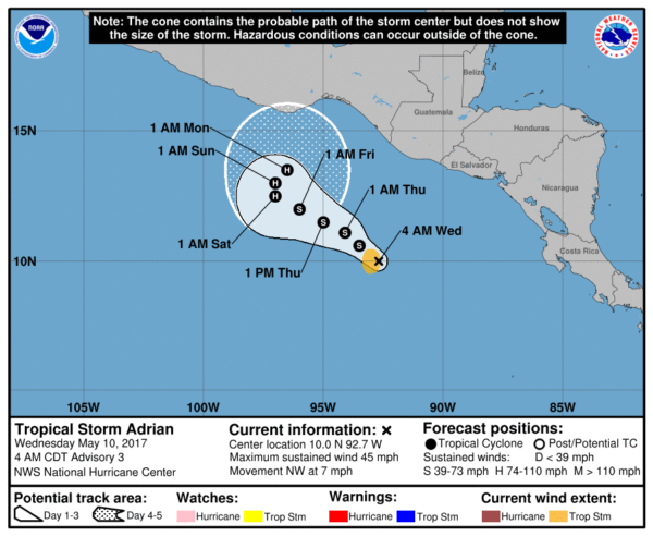
YO, ADRIAN: The first tropical storm of the season has formed over in the eastern Pacific; it is expected to become a hurricane by Friday night, meandering off the southern Pacific coast of Mexico and Central America. The hurricane season for the Atlantic basin begins June 1.
Click here to see the Beach Forecast Center page. Save Up To 25% on Spring Break Beach Vacations on the Alabama Gulf Coast with Brett/Robinson! The Beach Forecast is partially underwritten by the support of Brett/Robinson Vacation Rentals in Gulf Shores and Orange Beach. Click here to see Brett/Robinson’s best beach offers now!
WEATHER BRAINS: Don’t forget you can listen to our weekly 90 minute netcast anytime on the web, or on iTunes. This is the show all about weather featuring many familiar voices, including our meteorologists here at ABC 33/40.
CONNECT: You can find me on all of the major social networks…
Facebook
Twitter
Google Plus
Instagram
Pinterest
Snapchat: spannwx
I have weather programs today at the University of Alabama in Tuscaloosa, and at Riverchase Elementary in Hoover. Look for the next Weather Xtreme video here by 4:00 this afternoon… enjoy the day!
Category: Alabama's Weather, ALL POSTS, Weather Xtreme Videos
About the Author (Author Profile)
James Spann is one of the most recognized and trusted television meteorologists in the industry. He holds the AMS CCM designation and television seals from the AMS and NWA. He is a past winner of the Broadcast Meteorologist of the Year from both professional organizations.Subscribe
If you enjoyed this article, subscribe to receive more just like it.


