

Some Good News, But Not Out of the Woods Yet
CURRENT CONDITIONS
All of the action is located in south Alabama, where a Tornado Watch is still in effect for Baldwin, Butler, Coffee, Conecuh, Covington, Crenshaw, Escambia, Geneva, Mobile, and Monroe counties until 7PM CDT. A tornado warning is in effect for Butler, Conecuh, Covington and Crenshaw counties until 3PM CDT. A severe thunderstorm warning is in effect for the same counties outside of the tornado warning polygon until 3:15PM CDT.
A line of light to moderate rain is pushing its way through the eastern part of the state without any lightning. More light to moderate rain is falling over northwestern parts of the state, stretching from Samantha in Tuscaloosa county, and fans out northward to Florence and Athens. Temperatures are ranging from the lower to mid 60s in the northern half of the state, with mid to upper 60s in south Alabama, except for upper 70s in extreme southeastern Alabama.
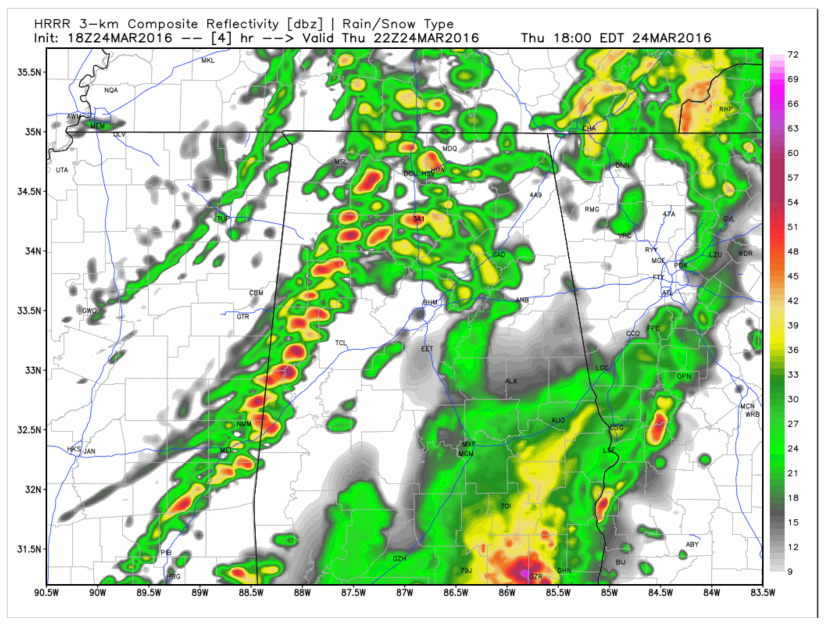
Simulated Radar from the HRRR Model at 5 p.m. CDT this afternoon.
SEVERE WEATHER THREAT
We have been concerned all day about the output from what is generally regarded to be our best short term mesoscale model, the HRRR. It has been very bullish on instability rising quickly just ahead of the front which is now just across the Mississippi River.
I don’t think it anticipated the development of the massive storms off the Louisiana coast very well. Those storms are now over South Alabama, wreaking havoc. This type of explosive convective development can cut off the northward transport of moisture.
We have been hanging our hat on the fact that a strong low level jet was positioned behind this activity over Louisiana and southern Mississippi. But that is just above the surface and is not reflecting the moisture flux at the surface. Dewpoints have actually fallen over the past few hours over southern Mississippi and Central Louisiana.
The past couple of runs of the HRRR have responded by backing down a bit on the instability available for storms that are still forecast to form rapidly between 4-5 p.m. from Northwest Alabama down through Winston, Fayette, Walker, Pickens and Greene Counties. These storms look cellular in nature and could become severe.
These will be from Decatur to east of Jasper to Tuscaloosa by 6 p.m. and into Birmingham by 7 p.m.
The temperature/dewpoints at Tuscaloosa and Birmingham are expected to be 70/64 and 69/61 by 6 p.m.
The best chance for severe weather may come in a brief window from 4-6 p.m. from Fayette and Walker Counties down through Pickens, Tuscaloosa, Sumter and Greene Counties. The storms should weaken quickly after 6 p.m.
The storms currently over South Central Alabama will move into Georgia by 6 p.m.
Conditions will be favorable for severe weather and tornadoes in a brief window over eastern Alabama between 5-7 p.m. south of I-20 and east of I-65 in places like Alex City, Auburn, Tuskegee and Dadeville, but I am not sure there will be storms there at that time.
Category: Alabama's Weather, Severe Weather
About the Author (Author Profile)
Bill Murray is the President of The Weather Factory. He is the site's official weather historian and a weekend forecaster. He also anchors the site's severe weather coverage. Bill Murray is the proud holder of National Weather Association Digital Seal #0001 @wxhistorianSubscribe
If you enjoyed this article, subscribe to receive more just like it.


