

Coolish Day for Mid May
What a pleasant feeling to step outside this morning and feel some cooler, drier air in place across North and Central Alabama. Many spots across northern Alabama dipped into the 40s this morning which most reporting stations in Central Alabama were in the lower 50s. And this cooling trend will continue today with the arrival of a cold front moving into and through the Southeast US from the northwest. The arrival time of the front will make the high temperature forecasts somewhat challenging since it will be moving through around the middle of the day. Locations south of Birmingham will warm into the 80s while points from Birmingham northward should be capped out in the middle and upper 70s. Only a few passing clouds are expected with the front but you may also notice a distinct wind shift as the wind goes around to the northwest behind the front and becomes noticeably breezier.

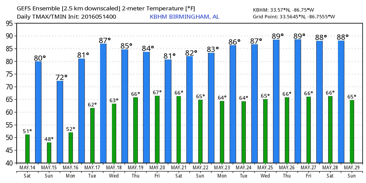
High pressure settles into the Southeast US tonight and Sunday, so I expect to see some chilly temperatures as the morning lows Sunday morning will be well down into the 40s. These values will be a good 10 degrees cooler than what we typically see in the middle of May. The air will also be noticeably drier with dew points potentially reaching the upper 30s. For highs Sunday, those will also be about 10 degrees cooler than our 30-year averages with highs in the range of 68 to 72.
If you are headed to the beach, you can expect mostly sunny days and fair nights from Gulf Shores to Panama City through the weekend. Highs will be around 80 degrees are in the forecast. Water temperatures were in the range from the mid 70s to lower 80s at various locations from Dauphin Island east to Panama City. See a very detailed beach forecast here.
The Regions Traditions golf tournament returns to beautiful Greystone Golf and Country Club next week, May 18-22. A little too early for event specific forecast, but there appears to be the threat of showers and storms each day. Find out more information and purchase your tickets here.
Monday and Tuesday we begin the process of bringing moisture back into the Southeast US as the surface high moves off the Southeast US coast bringing the surface flow back around to the south. I believe we will stay dry as we start the week with a somewhat benign upper flow that gradually becomes southwesterly by mid week adding the element of additional moisture aloft.
For the latter half of the week, our upper air pattern will remain in a west to southwest flow as a deep trough takes up residence along the West Coast of the US. Weak short waves will move eastward in this upper flow, and with a weak frontal boundary also across the Southeast US, we will have a moisture laden atmosphere that should result in daily chances for showers driven mainly by diurnal heating but also focused with those transient weak short waves. This far out, it’t very difficult to pinpoint the exact time when these short waves will bring the best chance of showers, so the forecast for the latter half of the week ahead will be a little fluid. Temperatures will once again get back to seasonal values with highs around 80s and lows in the 60s.
The GFS is showing one short wave by next Saturday to be stronger and that may bring about a much better chance for showers. But the timing of this feature could easily change a good deal since we are verging on voodoo country.

The upper air pattern continues to be quite changeable as we move out into voodoo country or week 2. The pattern has a disturbing look to it from May 22nd through the 25th as the GFS is depicting a closed low meandering over Georgia and South Carolina. As James notes from time to time, upper closed low, weatherman’s woe! We’ll have to watch future model runs to see if this feature continues to be depicted. But the current model run finally dissipates that feature around the 26th but brings in a fairly deep trough into the picture across the eastern US around the 27th. This would spell a possible wet period along with some cooler weather to close out May.
Due to travel plans with an early flight, I’m not sure about the Weather Xtreme Video for Sunday morning. I will try to post a discussion even if I can’t get the video done. Enjoy this fabulous May day. Don’t forget to come out to the Buck Creek Festival in Helena. Be sure to come by the stage area and say hello. Godspeed.
-Brian-
Category: Alabama's Weather
About the Author (Author Profile)
Brian Peters is one of the television meteorologists at ABC3340 in Birmingham and a retired NWS Warning Coordination Meteorologist. He handles the weekend Weather Xtreme Videos and forecast discussion and is the Webmaster for the popular WeatherBrains podcast.Subscribe
If you enjoyed this article, subscribe to receive more just like it.


