

Midday Nowcast: Hot & Humid, Scattered Showers Possible
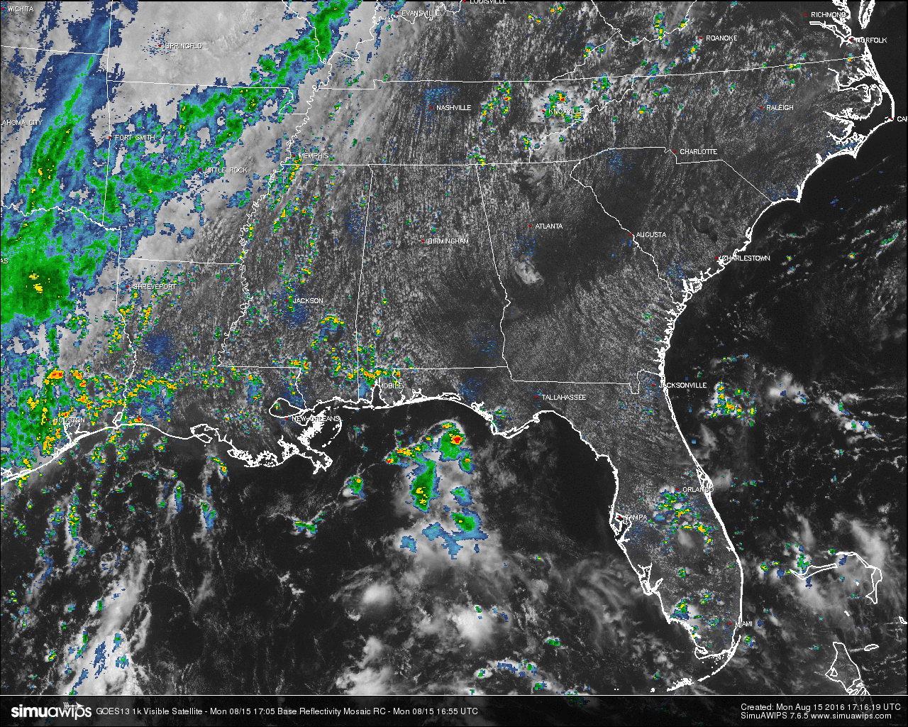
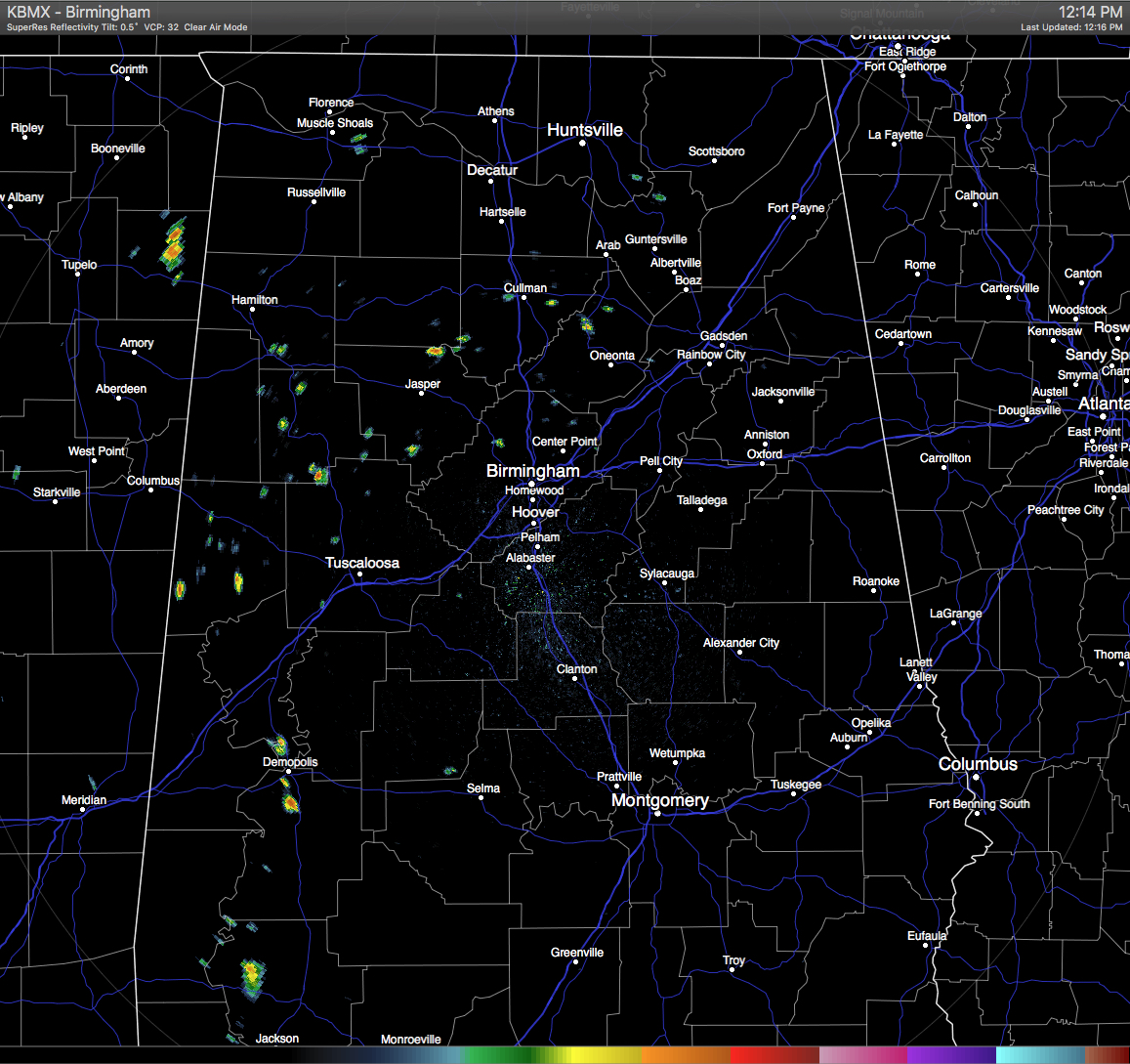
Here at the midday hour we have a few isolated showers dotting the radar, mainly in the western counties of the area, with a few showing up in Walker, Cullman, and Blount counties. We currently have partly to mostly clear skies across Central Alabama on the latest visible satellite imagery. As I was typing this entry, a shower passed over or nearby the Birmingham Airport and dropped the temperature by 4 degrees.
Across the southeast, most of the rain activity is located back to our west in Arkansas, Oklahoma, and Texas. Even though there are scattered showers and storms in Louisiana, most of the hardest hit places from the pesky low that caused all of the flooding is getting a break.
TEMPERATURES AT THIS HOUR: Here is a list of temperature observations from across the area:
Birmingham 84
Tuscaloosa 88
Gadsden 88
Anniston 90
Cullman 84
Jasper 88
Alexander City 88
Montgomery 89
CODE GREEN AIR QUALITY: The Air Quality Index for the Birmingham Metropolitan Area is in the “Code Green” for ozone and particulate matter 2.5. No actions needed.
TODAY’S CLIMATOLOGY FOR BIRMINGHAM: The normal high for August 15th is 91, while the normal low is 69. The record high for today was set back in 2007 at 104. The record low was set back in 2004 at 54.
WHAT TO EXPECT FOR TODAY: Skies will be partly to mostly sunny with scattered afternoon, showers and thunderstorms. Afternoon highs will be in the low 90s. Odds for any one spot getting rain is about one in three. Any showers or storms should come to an end by 10PM, and overnight lows will be in the 70s.
TUESDAY’S WEATHER: Almost the same story as Monday’s weather… Partly to mostly sunny skies with scattered showers and thunderstorms. Afternoon highs will be in the low 90s for the most part. Odds for any one spot getting rain is about one in three, and don’t be surprised if showers pop before noon. Once again, shower activity should die off by 10PM, and overnight lows will be in the 70s.
HEADED TO THE BEACH: Pretty good weather on the coast this week from Gulf Shores over to Panama City Beach. About 7 to 9 hours of sunshine daily with only widely scattered showers and storms; highs 87-90 on the immediate coast, with low 90s inland. Rip currents are an issue today, as red flags fly on our forecasted beaches. Already, 10 water rescues have been made in Destin. See a very detailed Gulf Coast forecast here.
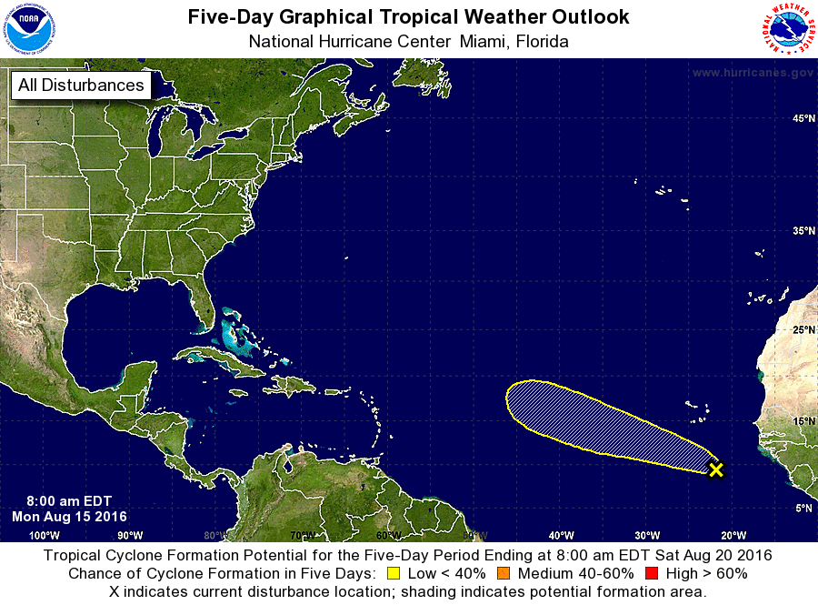
THE TROPICS: All is quiet for the Gulf of Mexico and the Caribbean Sea, but there is a tropical wave located over the far eastern Atlantic Ocean just a few hundred miles south of the Cabo Verde Islands. Some gradual development is possible during the next few days before it enters less-favorable conditions. It is expected to move west to west-northwestward over the eastern Atlantic through mid-week.
ON THIS DAY IN 1987: Thunderstorms developing ahead of a sharp cold front produced severe weather in the Upper Midwest during the afternoon and evening hours, with Minnesota and eastern South Dakota hardest hit. A thunderstorm in west central Minnesota spawned a tornado at Eagle Lake which killed one person and injured eight others. A thunder- storm in eastern South Dakota produced softball size hail at Warner.
THE BLOG IS ON TWITTER: Be sure to follow the Alabama Wx Weather Blog on Twitter. Just click here to start following our feed.
WEATHERBRAINS: This week, we will be previewing the upcoming National Weather Association Annual Meeting with the President, Executive Director, Social Media Chair and Program Chair. This is the show all about weather featuring many familiar voices, including our meteorologists at ABC 33/40. You can listen anytime on the web, or on iTunes. You can find it here.
ADVERTISE WITH US: Deliver your message to a highly engaged audience by advertising on the AlabamaWX.com website. The site enjoyed 10.2 MILLION pageviews in the past 12 months. Don’t miss out! We can customize a creative, flexible and affordable package that will suit your organization’s needs. Contact Bill Murray at (205) 687-0782.
Category: Alabama's Weather
About the Author (Author Profile)
Scott Martin is an operational meteorologist, professional graphic artist, musician, husband, and father. Not only is Scott a member of the National Weather Association, but he is also the Central Alabama Chapter of the NWA president. Scott is also the co-founder of Racecast Weather, which provides forecasts for many racing series across the USA. He also supplies forecasts for the BassMaster Elite Series events including the BassMaster Classic.Subscribe
If you enjoyed this article, subscribe to receive more just like it.


