

Scattered Showers/Storms By Afternoon
ANOTHER DOG DAY AFTERNOON: It’s that time of the year when weather forecasting gets into a rut. Most days in August, if you say the weather will be hot and humid with the chance of an afternoon storm in spots, you will have it nailed. And that is the story today. Morning sunshine, scattered showers and storms this afternoon and early tonight. The chance of any one spot seeing a shower or thunderstorm is about one in four, and the high will be in the low 90s for most places.
TOMORROW/FRIDAY: The upper ridge across the Deep South will weaken, the air aloft will be a bit colder, and the air becomes more unstable. This will mean an increase in the number of scattered showers and thunderstorms both days…. otherwise expect a mix of sun and clouds with highs in the 87 to 90 degree range.
THE WEEKEND: Not much change. Not sure I would call it a “rainy” weekend, but scattered to numerous showers and storms are likely Saturday and Sunday with a moist, unstable airmass in place. The sun will be out at times, and maximum temperatures will be in the upper 80s for most communities, which is below average for August in Alabama. Best chance of showers and storms will come during the afternoon and evening hours, but some late night or morning rain can’t be ruled out.
NEXT WEEK: Global models continue the idea of drier air creeping into the northern half of Alabama early in the week. As often stated here, cold fronts rarely get this far south in August, but if by chance this idea verifies, we will see lower humidity and cooler nights by Tuesday. Still not totally convinced this happens; see the Weather Xtreme video for maps, graphics, and more details.
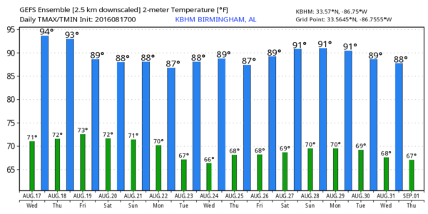
AT THE BEACH: About 7 to 9 hours of sunshine daily on the coast from Panama City Beach over to Gulf Shores through the weekend with only widely scattered showers and storms. Highs 87-90 on the immediate coast, with low 90s inland. See a very detailed Gulf Coast forecast here.
TROPICAL DEPRESSION SIX FORMS: This is in the eastern Atlantic, and should become Tropical Storm Fiona later today (bring on the Shrek jokes…). The system will be gaining latitude, and there is a high probability this won’t impact the U.S… in fact it is unlikely to impact any land mass.
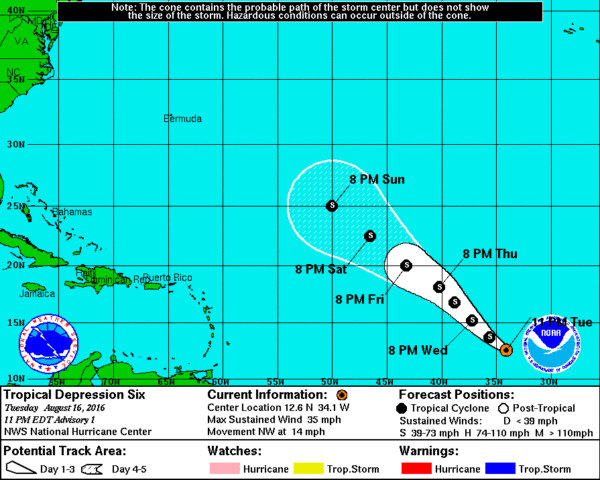
The rest of the Atlantic basin is quiet, although a series of waves will be coming off the African coast in coming days that will need to be watched.
WEATHER BRAINS: Don’t forget you can listen to our weekly 90 minute netcast anytime on the web, or on iTunes. This is the show all about weather featuring many familiar voices, including our meteorologists here at ABC 33/40.
CONNECT: You can find me on all of the major social networks…
Facebook
Twitter
Google Plus
Instagram
I will be speaking to a group of retirees from the Baptist Health System this morning at Princeton Medical Center in Birmingham… look for the next Weather Xtreme video here by 4:00 this afternoon. Enjoy the day!
Category: Alabama's Weather
About the Author (Author Profile)
James Spann is one of the most recognized and trusted television meteorologists in the industry. He holds the AMS CCM designation and television seals from the AMS and NWA. He is a past winner of the Broadcast Meteorologist of the Year from both professional organizations.Subscribe
If you enjoyed this article, subscribe to receive more just like it.


