

Hot Afternoons; 99L Hanging In There
RADAR CHECK: Scattered showers and storms are over the northern third of Alabama this afternoon… moving to the west…
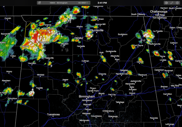
NWS in Huntsville has issued a severe thunderstorm warning for parts of Colbert and Franklin Counties at 3:40 p.m.
Heaviest storms are over Northwest Alabama, where very heavy rain is falling along with frequent lightning and gusty winds at mid-afternoon. These showers and storms will fade once the sun goes down later this evening. Temperatures away from the storms are mostly in the low 90s.
HIGH SCHOOL FOOTBALL: Can’t totally rule out a shower or storm at few stadiums during the first quarter of the games across Alabama tonight, but most of the showers will be over by 8:00 p.m. It will be a very humid, warm night with temperatures falling from the 80s into the upper 70s.
THE WEEKEND AND NEXT WEEK: The upper ridge holds, and our weather won’t change much. Hot humid days, a partly sunny sky, and “widely scattered, mostly afternoon and evening showers and thunderstorm”. Highs low to mid 90s. It is pretty much a persistence forecast for the next seven days; the only potential change in the weather next week would involve something from the tropics, but for now it looks like our friend “99L” won’t impact our state directly.
ACTIVE TROPICS: Gaston, a tropical storm in the Central Atlantic, doesn’t look very healthy this afternoon, but NHC still expects this to regain hurricane status over the weekend. It will recurve into the open water east of Bermuda, and is no threat to land.
Another disturbance is over the Northwest Gulf of Mexico; that will drift into Texas with no development.
Eyes remain on “Invest 99L”, an open tropical wave that will move through the Florida Straights and into the Southeast Gulf of Mexico over the weekend. There has been an increase in convection near the wave, and it seems as shear is lessening a bit. So, some chance of slow development continues.
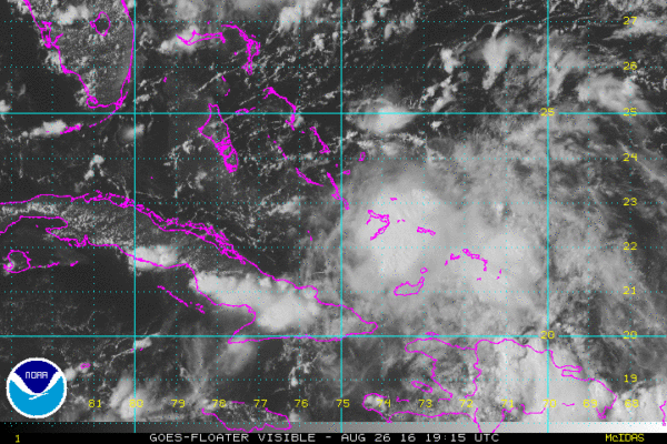
The global models (both the GFS and the Euro) show this feature moving up the Florida west coast, with a turn back to the east next week. This solution seems pretty plausible, and if it verifies Alabama would not be impacted directly, with most of the rain off to the east over the Florida Peninsula and Southeast Georgia.
But, we stress there is still a good deal of uncertainty, and it is still impossible to resolve the track and intensity of the system in coming days. Confidence is high, however, that this will not impact the Central Gulf Coast over the Labor Day weekend. Keep up with the latest blog discussions over the weekend.
AT THE BEACH: Mostly sunny days, fair nights through Monday on the coast from Gulf Shores to Panama City Beach, with just a few widely scattered showers or storms around. Beyond that, the weather will all depend on the behavior of “99L”. Highs on the immediate coast will remain in the upper 80s, with low to mid 90s inland. See a very detailed Gulf Coast forecast here.
WEATHER BRAINS: Don’t forget you can listen to our weekly 90 minute netcast anytime on the web, or on iTunes. This is the show all about weather featuring many familiar voices, including our meteorologists here at ABC 33/40.
CONNECT: You can find me on all of the major social networks…
Facebook
Twitter
Google Plus
Instagram
Look for my next Weather Xtreme video here Monday morning by 7:00… Brian Peters will have the video updates here tomorrow and Sunday. Enjoy the weekend!
Category: Alabama's Weather
About the Author (Author Profile)
James Spann is one of the most recognized and trusted television meteorologists in the industry. He holds the AMS CCM designation and television seals from the AMS and NWA. He is a past winner of the Broadcast Meteorologist of the Year from both professional organizations.Subscribe
If you enjoyed this article, subscribe to receive more just like it.


