

Isolated Showers Once Again Today
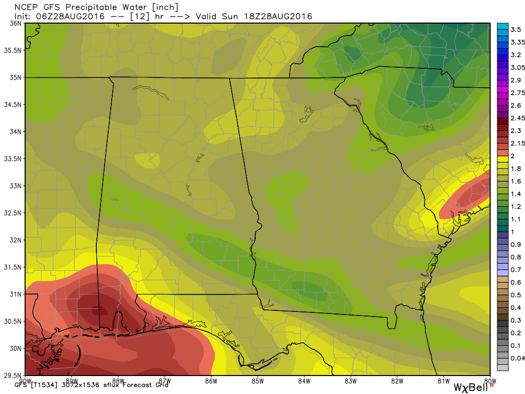
Showers developed yesterday afternoon across the northern third of Alabama, pretty much in line with the precipitable water chart. This morning, clouds were present in the Alabama sky generally over the southern two-thirds of the state. Those clouds will still allow some sunshine as temperatures rise into the lower 90s. Showers and storms will once again be isolated, but the precipitable water chart for this afternoon suggests the better chances for a passing shower will be in North and Central Alabama. It will still be hit or miss as not everyone will see one of those showers.
Beachgoers will find more sun than clouds with only a few passing isolated showers/storms a possibility today. Eyes are on the tropics as we could see additional showers and storms along the Gulf Coast, especially by the middle of the week. Highs along the beach will be in the upper 80s with overnight lows in the upper 70s. The sea water temperature at Perdido Pass at Orange Beach was 87 degrees. See the complete Gulf Coast 7 Day Planner here.
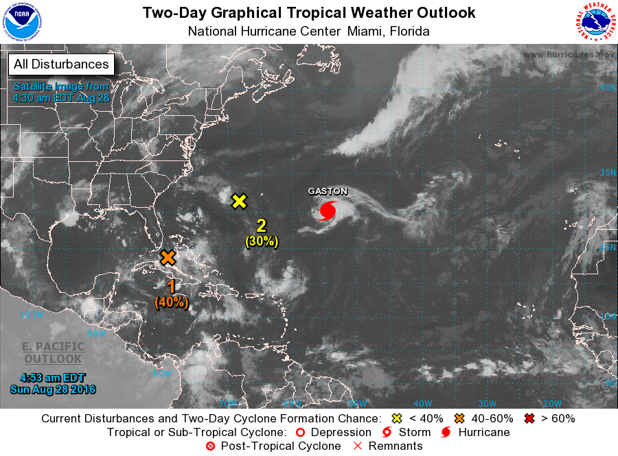
The tropics remain busy. Gaston is in the Central Atlantic and has become a hurricane. It is expected to turn to the northeast later today and remain well away from land. The area of disturbed weather that was just southwest of Bermuda yesterday has moved westward and remains disorganized. It is expected to continue westward approaching the Carolinas before turning northeastward and heading out to sea. The third area, also known as Invest 99L, can’t seem to make up its mind as to what to do. The area of disturbed weather is rather large covering a good portion of the eastern two-thirds of Cuba and much of the southern half of the Bahamas. There is still no well defined center. The future course of 99L makes forecasting anywhere from Tampa to Lake Charles a bit iffy over the next week. Conditions for development as it moves through the Florida Straits are not very good, however, as it reached the Southeast Gulf of Mexico those conditions are expected to get better. There is still a great deal of uncertainty on the future course and strength of 99L, so forecasts may have to be adjusted as we get a better handle on this broad low. For now, the GFS and the ECMWF seem to be in fairly good agreement on the course of this low. While they agree on the track, they seem to be wide apart on the intensity. The ECMWF is quite a bit stronger than the GFS that has a 1010 millibar center on Thursday as compared with the 985 millibar low at that same time. This is going to be a cliff hanger, so we’ll all need to stay tuned.
The rest of this discussion may be way off depending on the motion of Invest 99L. With the ECMWF and GFS tracks in close agreement on location and timing, I’m going to buy into that solution. However, I do believe the GFS may be too weak in the forecast intensity while the ECMWF may be a tad too strong.
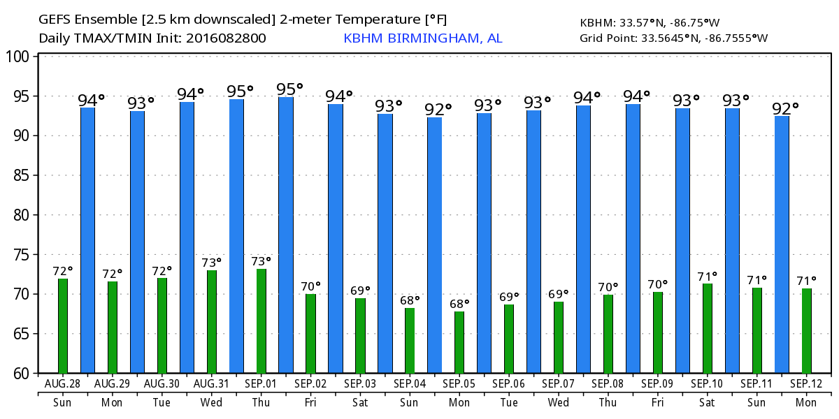
The strong upper ridge is still forecast to undergo weakening as the main ridging slides back across the western states. This allows the development of a weak trough over the East Coast. This should be the pattern present as Invest 99L comes into the eastern Gulf on Thursday. The troughiness is forecast to become a little stronger (deeper) so it should guide Invest 99L out across North Florida and into the Southeast Atlantic. Additional uncertainty enters the picture for next weekend as the GFS wants to hold the tropical disturbance in the vicinity of Jacksonville, FL, while the ECMWF has no part of that and moves the disturbance briskly northeastward hugging the Southeast US coast. Since Central Alabama will be on the western and dry side of the tropical system, about the best we can expect to see in the way of rain will be isolated showers. Sinking motion form the disturbance could inhibit even those small chances for showers. Under this scenario, we can expect to see highs for the week ahead in the lower and middle 90s.
Looking out into voodoo country, the GFS keeps a ridge over the Southeast US until the 7th of September. Another tropical system, the one expected to come off the African coast on Monday/Tuesday, is forecast to be a potent storm coming through the Bahamas and into Georgia and the Carolinas between the 10th and 12th of September. Remember, this is voodoo country, so this is not a forecast for landfall of the next storm. You certainly cannot look at the long range charts and not identify this feature. But that feature may not be anywhere near the location noted now – it might be out in the Atlantic or gone completely. There is no skill in a specific forecast this far into the future.
James Spann will have the next edition of the Weather Xtreme Video posted here first thing on Monday morning. Check back here often for updates on our weather. Have a great day and Godspeed.
-Brian-
Category: Alabama's Weather
About the Author (Author Profile)
Brian Peters is one of the television meteorologists at ABC3340 in Birmingham and a retired NWS Warning Coordination Meteorologist. He handles the weekend Weather Xtreme Videos and forecast discussion and is the Webmaster for the popular WeatherBrains podcast.Subscribe
If you enjoyed this article, subscribe to receive more just like it.


