

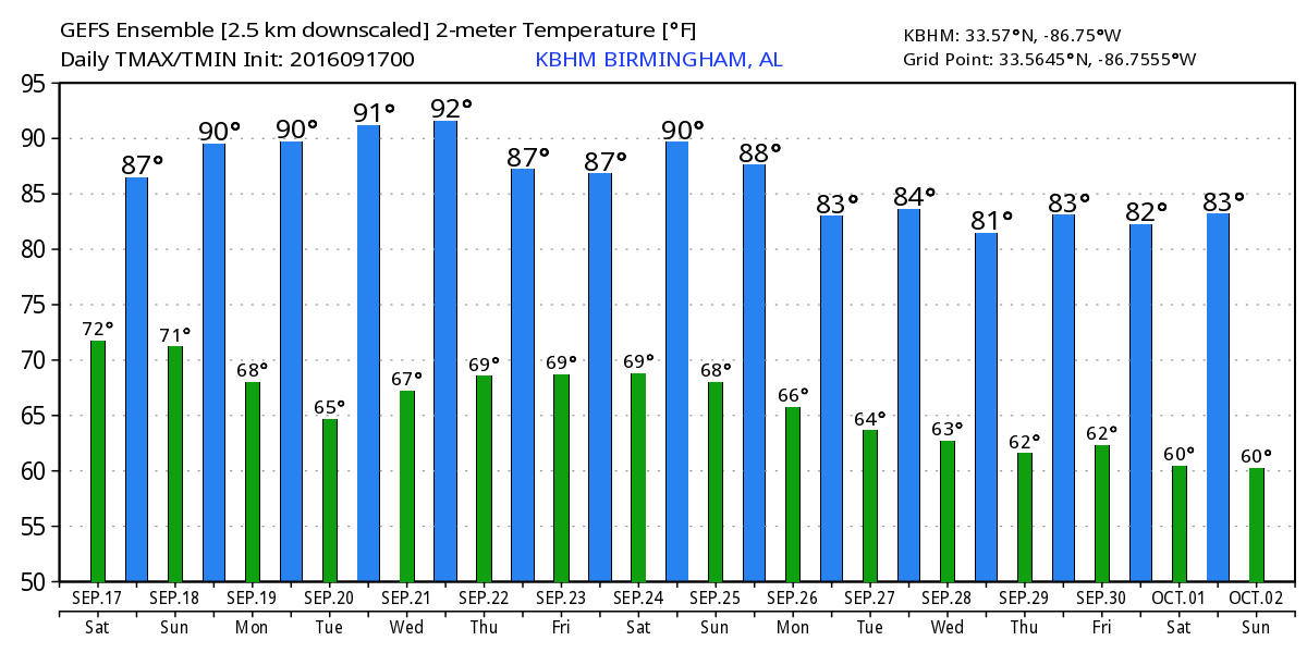
Wet Weekend, Dry Again Next Week
Alabamians waking up to some clouds this morning. Dew points already in the upper 60s will climb into the range of 70 to 72 for much of the weekend as a cold front slowly approaches Central Alabama. There is also an upper trough that will be approaching, and that combination will spell about our best chances for some widespread rain in a long time. The Birmingham high yesterday was a warm 93 degrees, but it looks like the clouds and showers will help to keep the high temperatures today in the 80s – mainly about 84 to 87 range.
Alabama travels to Oxford to play Ole Miss with a 2:30p CT kickoff. The sky will be partly sunny, and a passing shower or storm is possible during the game. The high temperature will be in the lower 80s falling into the mid 70s by the final whistle, and humidity levels will be high.
Auburn hosts Texas A&M this evening at Jordan-Hare Stadium with a 6:30p CDT kickoff. A shower or thunderstorm is possible during the game, but not especially likely. Temperatures will fall from near 80 degrees at kickoff into the lower 70s by the final whistle.
Headed to the beach? There will be mostly cloudy skies with only 3 to 4 hours of sunshine today and Sunday along the coast from Gulf Shores to Panama City Beach with scattered storms around. Highs will be in the middle 80s on the immediate coast, with low 90s inland. Sunshine returns and the weather warms up as we head into next week. See a very detailed Gulf Coast forecast here.
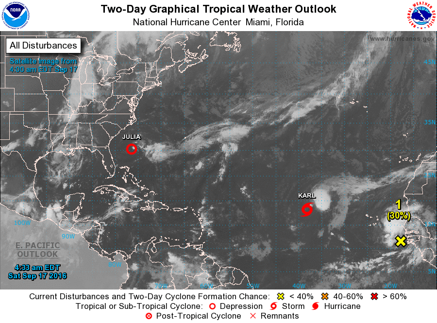
SPC has little in the way of severe weather potential across the Nation. Day 1 we see the standard slight risk over the Texas Panhandle and West Texas with a marginal risk area from eastern Ohio into western New York. Day 2 there are no risk areas. Day 3 has a marginal risk area from Southeast Iowa to southern Lake Michigan. And the tropics stay active. Julia is a depression and meandering in the Southwest Atlantic where she should finally dissipate. Karl is struggling right now, but with warm water and less shear forecast in the ocean along the anticipated track of Karl, Karl should slowly strengthen with time possibly reaching hurricane force by Wednesday or Thursday while it remains at sea. And an area of disturbed weather just coming off the African coast is not expected to develop right away, however, conditions do appear favorable for slow development into the middle of next week.
The upper trough helping to support showers and thunderstorms today and Sunday will move by on Monday as the front moves to North Florida. Dew points should be noticeably lower as dry air comes into Central Alabama on Monday. While the air will be noticeably drier Monday through Thursday, temperatures will continue to dance around the 90-degree mark through the middle of the week.
Thursday we begin to have confidence issues with the forecast. The lack of confidence comes as a result of a weak upper level low over South Georgia. These features are weak and this one is forecast to move west into Alabama on Friday. The GFS seems to be underplaying the potential for rain with only small chances. My forecast will reflect that for now, but upper lows can be treacherous to forecast. Remember it was an upper low that produced the devastating flooding in Louisiana just weeks ago. So we’ll keep a chance for showers in the forecast, but we’ll also watch to see how the GFS handles this feature and try to focus on what the impact may be. With a surface high to the northeast of us, we could see this upper low bring some Atlantic moisture with it as it meanders slowly westward.
The long range forecast brings another trough with a strong cold front across the Southeast US on the 28th of September. The oh too familiar ridge closes out September on the 30th. Looks like we start October on a warm note, however, a big trough in the west could bring some wet weather our way during the first few days of October.
Thanks for tuning into the blog. I expect to post the next edition of the Weather Xtreme Video here by 7 am or so on Sunday. Have a great day, keep an umbrella handy, and Godspeed.
-Brian-
Category: Alabama's Weather
About the Author (Author Profile)
Brian Peters is one of the television meteorologists at ABC3340 in Birmingham and a retired NWS Warning Coordination Meteorologist. He handles the weekend Weather Xtreme Videos and forecast discussion and is the Webmaster for the popular WeatherBrains podcast.Subscribe
If you enjoyed this article, subscribe to receive more just like it.


