

Pattern Change Likely Next Week
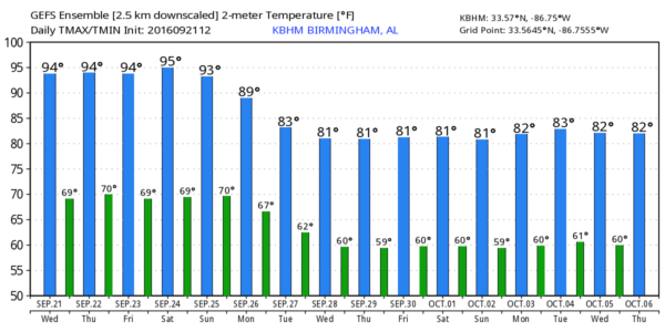
PLEASANT NIGHTS, HOT AFTERNOONS, NO RAIN: The weather just won’t change much across the great state of Alabama through the weekend thanks to an upper ridge, and dry air in place. We are forecasting mostly sunny days and fair nights through Sunday with highs in the low 90s, and lows in the upper 60s. Pretty straight forward forecast.
FALL ARRIVES TOMORROW: This is the last Wednesday of the summer of 2016; the autumnal equinox is tomorrow morning at 9:21 CT when the sun is directly over the equator.
FOOTBALL WEATHER: For the high school games Friday night, the sky will be mostly fair with temperatures falling through the 80s.
Alabama hosts Kent State at Bryant-Denny Stadium Saturday morning (11:00a CT kickoff)… the sky will be partly to mostly sunny with temperatures rising from near 88 at kickoff, to 93 degrees by the final whistle.
Auburn will host LSU at Jordan-Hare Stadium Saturday evening (5:00p CT kickoff)… the sky will be mostly clear with temperatures dropping from near 89 degrees at kickoff to near 80 by the end of the game.
CHANGES NEXT WEEK: Global models show a deep upper trough setting up just west of Alabama; that should drive a cold front in here Monday, and bring us a chance of showers and possibly a few thunderstorms. The front will “run of out gas” somewhere around the Alabama/Georgia line Tuesday. One way or another, heat levels will drop significantly next week; the GFS is printing a high of only 79 degrees for Birmingham Tuesday. Where dry air moves in following the front, 50s are possible by Tuesday or Wednesday morning.
But, with the front becoming nearly stationary over far East Alabama, clouds could linger, and the GFS hints that showers and storms are possible on Wednesday with the front drifting westward across the state. Confidence in specific details is low, but the idea of lower temperatures next week looks likely. See the Weather Xtreme video for maps, graphics, and more details.
AT THE BEACH: Mostly sunny days, fair nights, and only isolated storms on the coast from Panama City Beach over to Gulf Shores through the weekend. Highs in the upper 80s on the immediate coast, with low 90s inland. See a very detailed Gulf Coast forecast here.
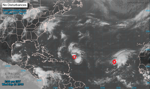
TROPICS: Tropical Depression Karl, in the middle of the Atlantic, is still fighting shear and dry air. If it survives, it will recurve east of Bermuda Saturday, and could briefly strengthen into a hurricane over open water. It is no threat to land.
To the east, Tropical Storm Lisa is moving north/northwest, and will probably dissipate in 3-5 days. It won’t be close to any land mass. The rest of the Atlantic basin is quiet for now.
WEATHER BRAINS: Don’t forget you can listen to our weekly 90 minute netcast anytime on the web, or on iTunes. This is the show all about weather featuring many familiar voices, including our meteorologists here at ABC 33/40.
CONNECT: You can find me on all of the major social networks…
Facebook
Twitter
Google Plus
Instagram
Look for the next Weather Xtreme video here by 7:00 a.m. tomorrow…
Category: Alabama's Weather
About the Author (Author Profile)
James Spann is one of the most recognized and trusted television meteorologists in the industry. He holds the AMS CCM designation and television seals from the AMS and NWA. He is a past winner of the Broadcast Meteorologist of the Year from both professional organizations.Subscribe
If you enjoyed this article, subscribe to receive more just like it.


