

Dry Conditions Deepen Drought
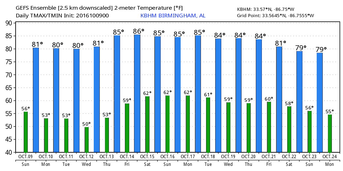
Clear skies prevail across nearly all of the Southeast US this morning as we wake up to some cool temperatures. Our Skywatcher at Black Creek reporting 39 for a low this morning, first low in the 30s for this Fall season to my knowledge. The rest of us were generally in the lower and middle 50s. Lots of sunshine on tap for today, so look for highs to climb to around 80 degrees.
Beachgoers will find gorgeous weather with plenty of sun and fair nights into next week. Highs will be in the lower 80s, and the sea water temperature at Perdido Pass at Orange Beach was 82 degrees. See the complete Gulf Coast 7 Day Planner here.
The Barber Vintage Motorcycle Festival wraps up today at the Barber Motorsports Park. Expect an abundance of sunshine and temperatures in the upper 70s and lower 80s much of the day. Take the sunscreen if you are heading out that way. Get ticket information right here.
SPC has only a small area of marginal risk for severe storms today in southern New Mexico. No areas of organized severe storms expected for Day 2 or 3.
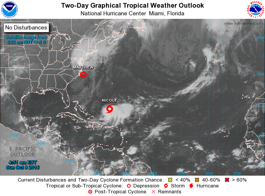
Matthew has become a post tropical cyclone and was beginning to pull away from the Outer Banks of North Carolina. The NWS is reporting record breaking flooding ongoing in North Carolina. Matthew is forecast to head out into the Central Atlantic over the next several days, so Matthew will not become a looping hurricane. Nicole looks a lot better on the satellite presentation this morning. Nicole is still a tropical storm and likely to remain at that level through the middle of the week. It is currently drifting slowly northward and should begin to pick up speed on Wednesday and could move across or very close to Bermuda on Thursday. Nicole is forecast to become a hurricane late Thursday or early Friday as it gets into the Central Atlantic.
Fire Danger Warnings for much of the northern half of the state of Alabama with breezy and dry conditions expected today. Open fires are not a good idea as the drought conditions continue to worsen.
The week ahead includes a series of upper level disturbances traversing the area, however, with the lack of moisture none of these disturbances is likely to produce and precipitation. About the only evidence of them passing will be some clouds for brief periods.
A weak one comes out of the Central Plains on Tuesday as it zips eastward and weakens. Another one follows that one on Thursday with a cold front expected to move through Alabama late on Thursday and early Friday. Precipitable water values remain low, generally below 1.5 inches so the only marker we’re likely to see will be some clouds.
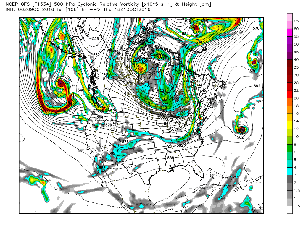
A short wave moves out of Oklahoma on Friday reaching the Carolinas on Saturday. Again, moisture values appear to be too low to bring anything more than clouds. Yet another trough comes out of the North Central US on Sunday and into Monday deepening across the eastern US. This promises to bring a nice cool down with it, but rain chances appear to be nearly nil.
Looking further into voodoo country, another sharp trough brings some chance of rain to the Southeast US around the 21st/22nd of October. This trough is fairly sharp so another cool down is likely to occur with this one. The upper air pattern flattens by the 24th of October with a vigorous short wave coming out of the Southwest US. The one could conceivably bring some Pacific moisture with it, but this is at the end of voodoo country and might not even be on the maps tomorrow.
I’m looking forward to being at the Vulcan AfterTunes event this afternoon at Vulcan Park. Music will be provided by Tragic City and Big Sam’s Funky Nation. If you come out to the event, be sure to stop by the ABC 3340 table/tent. Weather should be very nice for some music on Red Mountain. James Spann will have the next edition of the Weather Xtreme Video early on Monday morning. Have a great day and Godspeed.
-Brian-
Category: Alabama's Weather
About the Author (Author Profile)
Brian Peters is one of the television meteorologists at ABC3340 in Birmingham and a retired NWS Warning Coordination Meteorologist. He handles the weekend Weather Xtreme Videos and forecast discussion and is the Webmaster for the popular WeatherBrains podcast.Subscribe
If you enjoyed this article, subscribe to receive more just like it.


