

Multiple Day Rain/Storm Event Next Week
HIGH HOPES FOR NEXT WEEK: As I have written here many times, it takes time getting into a drought, and it takes time getting out of one as well. The blocked pattern “flipped” last week, opening the door for multiple traversing mid latitude waves. The pattern change doesn’t mean the heavens open up and it rains for days and days, it simply breaks the upper air traffic jam that had our state under a mean upper ridge for so long. Part of the process that brings rain back in here.
The first two waves came through with a very dry airmass in place, producing only light and spotty rain, pretty much meaningless concerning drought relief. But, next week should be a very different story. More about that later.
FOGGY START: A dense fog advisory is in effect for parts of Alabama this morning; once that burns off the sky will be partly to mostly sunny, and today’s high will be in the mid to upper 60s for most places. About 5-10 degrees cooler than yesterday.
THE ALABAMA WEEKEND: Sunny pleasant days, clear chilly nights. The high tomorrow will be in the 59-62 degree range, followed by mid 60s Sunday. A freeze is likely for most communities early Sunday morning with a low down in the low 30s.
IRON BOWL: A beautiful day for football in Tuscaloosa tomorrow. For our state’s biggest game of the year (Auburn at Alabama, 2:30p CT kickoff at Bryant Denny Stadium), the sky will be sunny with temperatures falling from 62 degrees at kickoff, into the 50s during the second half.
WET, STORMY WEEK: Prayers for rain will be answered next week. A storm system will move out of the Rockies Monday, and ahead of that the Gulf of Mexico will be “wide open”. A southerly flow will bring in moist air and higher dew points, and the first batch of showers and storms should move into the state Monday night. SPC has defined a risk of severe weather Monday for Louisiana and some of the adjacent states; we could very well have strong storms here Monday night; we will need to watch this closely for severe weather potential in Alabama… not necessarily for tornadoes, but for strong straight line winds.
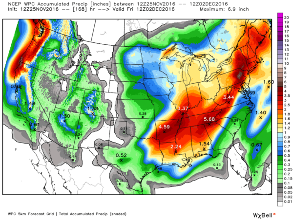
Showers and storms should continue into at least part of the day Tuesday, and a wave of low pressure will form along the front, with yet another batch of rain and storms likely on Wednesday. WPC (NOAA’s Weather Prediction Center) is now suggesting rain amounts of 2-4 inches for most of North/Central Alabama. This will punch the drought in the gut.
See the Weather Xtreme video for maps, graphics, and more details.
AT THE BEACH: Mostly sunny days, fair nights through the weekend from Panama City Beach to Gulf Shores. Highs will be in the 70s… showers and storms will arrive early next week. See a very detailed Gulf Coast forecast here.
OTTO: The system made it across Central America and is now in the eastern Pacific (now a tropical storm)… it will dissipate over open water next week. The Atlantic basin is quiet.
WEATHER BRAINS: Don’t forget you can listen to our weekly 90 minute netcast anytime on the web, or on iTunes. This is the show all about weather featuring many familiar voices, including our meteorologists here at ABC 33/40.
CONNECT: You can find me on all of the major social networks…
Facebook
Twitter
Google Plus
Instagram
We are on a holiday schedule so just one video today, but I will post more forecast notes here later this afternoon. Enjoy the day!
Category: Alabama's Weather
About the Author (Author Profile)
James Spann is one of the most recognized and trusted television meteorologists in the industry. He holds the AMS CCM designation and television seals from the AMS and NWA. He is a past winner of the Broadcast Meteorologist of the Year from both professional organizations.Subscribe
If you enjoyed this article, subscribe to receive more just like it.


