

Coldest Air So Far This Season Arrives Tomorrow
OVERCAST, COOL DECEMBER DAY: With the exception of far Northwest and Southwest Alabama… this has been a cloudy, cool day across the state with temperatures holding steady in the upper 40s and low 50s. Despite the clouds we have no rain on radar.
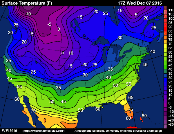
TO THE NORTH: Brutally cold Arctic air is over the northern states; Cutbank, Montana reports -1 (F) at 2p CT with a wind chill index of -16. That cold air is on the move, and we will feel some of it in Alabama tomorrow.
COLDEST SO FAR: The Arctic front will pass through tomorrow morning; there could be a few sprinkles involved, but very little moisture, and no measurable rain is expected. Once the front passes, north winds will increase to 15-25 mph, gusting at times to 30 mph. Temperatures won’t get past the low 40s in most places, and the wind will make it feel colder.
By Friday morning we expect a low between 20 and 25 degrees. The good news is that the sun will be back in full force Friday, but the weather stays cold with a high in he 38-42 degree range. Most of the “official” observation stations will see a low in the lower 20s early Saturday morning, but with a clear sky and light wind, the colder valleys and protected areas will see mid teens.
Last time it was this cold was back on February 10 when the low in Birmingham was 23.
THE ALABAMA WEEKEND: A warming trend begins Saturday afternoon; with a sunny sky we rise into the upper 40s. Then, clouds move in Sunday, and rain is likely late Sunday afternoon through Sunday night. Looks like rain amounts will be around 1/2″ for most of North/Central Alabama… that rain will end early Monday morning.
NEXT WEEK: The latest GFS run hints we could see some light rain on Wednesday (December 14), followed by another Arctic blast Thursday and Friday (December 15-16). The air toward the end of next week could be a little colder than what we will experience tomorrow and Friday. And, we need to mention there is no evidence of any snow or ice problems in Alabama for the next 10 days, despite what you might hear on the street. Take some time to watch the Weather Xtreme video for maps, graphics, and more details.
WEATHER BRAINS: Don’t forget you can listen to our weekly 90 minute netcast anytime on the web, or on iTunes. This is the show all about weather featuring many familiar voices, including our meteorologists here at ABC 33/40.
CONNECT: You can find me on all of the major social networks…
Facebook
Twitter
Google Plus
Instagram
Look for the next Weather Xtreme video here by 7:00 a.m. tomorrow…
Category: Alabama's Weather
About the Author (Author Profile)
James Spann is one of the most recognized and trusted television meteorologists in the industry. He holds the AMS CCM designation and television seals from the AMS and NWA. He is a past winner of the Broadcast Meteorologist of the Year from both professional organizations.Subscribe
If you enjoyed this article, subscribe to receive more just like it.


