Winter Storm Watch to be Upgraded Shortly; Here’s Latest Thinking
Just finished conference call with the National Weather Service and media partners. It is nice to have this kind of collaboration with a potentially high impact winter weather event coming up.
As you know, we always show our work here on the AlabamaWX Blog, so let’s dig in.
A complex winter weather scenario is setting up for Alabama for the next 48 hours. In short, an arctic front will arrive Friday morning, bringing really cold air to the state. The system driving the front will spin up a surface low over the Gulf of Mexico.
There will be two different events. The first will be snow associated with the front over Northwest Alabama starting Friday morning. The second will be an expanding shield of precipitation that will overspread the southern two thirds of the state of the state Friday through Friday night.
BIG QUESTIONS STILL
The low pressure system is the wild card with the cold air pretty much a given. The track of the low makes a huge difference as does its strength. A stronger low pushes more moisture northward, but a really strong low could bring in warmer air as well. A track further north pushes the rain/snow line further north, while a track too far to the south could mean no moisture and less precipitation.
MODELS NOT AGREEING
The morning run of the GFS, which has been very consistent, came in stronger and wetter, which would mean more wintry precipitation for Central Alabama. The European morning run is in and it is much further to the south. So with the GFS having shown a great deal of consistency and being more of a worst case scenario, I will weight that model more heavily.
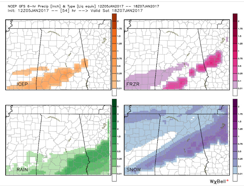
This graphic shows accumulation by precipitation type through noon Saturday according to the GFS model.
Here is how it looks like it will break down according to the GFS, which is on the aggressive side with the moisture.
RAIN
It will fall as all rain over South Alabama, generally south of a line from Citronelle to Evergreen to Troy to Phenix City.
MIX OF FREEZING RAIN AND SLEET
North of that line, to a line from Livingston to Verbena to Roanoke, there will be a significant accumulation of sleet and freezing rain. We aren’t talking about an ice storm on the order of 1982, but there will be ice accumulations, including 0.1 to 0.25 inches of freezing rain and 0.25 to 0.5 inches of sleet. This can cause significant travel problems and some power outages.
SNOW
A decent accumulating snow is going to affect a swath generally along and south of I-59 back down to a line from Butler to Selma to Wetumpka to Auburn and Valley. Accumulations in this area will mostly be in the 1-3 inch range with some place picking up 3-6 inches. There will be some disappointed people who are on the low end, which there will be some surprises on the high side too. The best chance for the higher accumulations will be over parts of Clay, Randolph, Coosa, Tallapoosa and Elmore Counties. Over North Alabama, a general dusting to 1 inch will occur. A few counties like Pickens, Fayette and Walker could get left out though.
EMPHASIZING THE ICE THREAT
I don’t think we are paying enough attention to the icing threat across the Central part of Alabama. It doesn’t take much freezing rain and sleet to cause real problems. We could even see a Freezing Rain Advisory for places like Monroeville, Greenville, southern Montgomery County, Dadeville and Auburn.
TIMING
…First light rain will reach Southwest Alabama between 9 pm-midnight tonight.
…The arctic front should reach I-59 by Sunrise
…Light snow should move into Northwest Alabama during the morning hours.
…Precipitation will begin to increase over Southwest Alabama by noon.
…Precipitation will be heaviest between 2 p.m. and 9 p.m., tapering after that from the west
…The best chances for precipitation will continue until the pre-dawn hours Saturday
…Most of the precipitation will be gone by 6 a.m. Saturday.
STILL A CHANGING FLUID SITUATION
As is often the case, we won’t know what is really going to happen until we see the whites of this system’s eyes, and that will come early tomorrow morning mostly likely. Stay tuned here for the very latest updates throughout the afternoon, overnight and the event itself. James will have his thoughts just after 3 p.m.
WINTER STORM WATCH TO BE UPGRADED SHORTLY
We will have the NWS Advisory and Warning Upgrades as soon as they are released. It sounds like the current watch area will be kept pretty much the same. One row of counties could be added to the south. I would expect much of the watch area will get a Winter Weather Advisory and that a Winter Storm Warning will be held in reserve for when things become a little clearer. The criteria for a Winter Storm Warning is two inches of snow, or 1 inch or more of sleet. We can’t rule out a Freezing Rain Advisory, but that would probably come later as well. Those are issued when a trace to just under ¼ inch of freezing rain is expected.
IMPORTANT NOTE
Please keep in mind that a Winter Weather Advisory is an UPGRADE over a Winter Storm Watch. We are prone to think that if a Watch is not upgraded to a Winter Storm Warning that the situation is not as bad. But remember, we can have significant travel and other issues with Winter Weather Advisory criteria ice and snow.
Category: Winter Weather
About the Author (Author Profile)
Bill Murray is the President of The Weather Factory. He is the site's official weather historian and a weekend forecaster. He also anchors the site's severe weather coverage. Bill Murray is the proud holder of National Weather Association Digital Seal #0001 @wxhistorianSubscribe
If you enjoyed this article, subscribe to receive more just like it.


