

The Bell Sounds for Round Three: Storms Intensifying Again, Warnings Issued
Round three of our weekend severe weather event is underway across the Southeast. After a second deadly night of severe weather, where 11 people died in Georgia, more severe weather is occurring and will continue today.

Severe thunderstorm warning was just issued for several counties in South Central Alabama including Autauga, Chilton, Dallas and Lowndes. A tornado warning was just issued for Autauga County.
A closed upper level low over Arkansas is pushing east early this afternoon. Across Mississippi and southwestern Alabama, A wide phalanx of showers and some thunderstorms are lifting northeastward. Severe thunderstorm warnings are in effect across Clarke, Monroe and Wilcox Counties in Southwest Alabama. Storms have lifted as far north as Selma.
To the southeast, a coastal warm front has lifted northward into South Central Alabama. The dewpoint is 67F at Troy and 68F at Evergreen. There are dewpoints in the lower 70s over Southeast Alabama and the Florida Panhandle.
A surface low is developing north of Mobile, and this surface low will lift northeastward across East Central Alabama. As it does, it will drive the warm front further inland over South Central and Southeast Alabama. Instability values are running 500-1,000 joules/kg across much of the southeastern two thirds of Alabama. Bulk shear values are 50-70 knots, which is sufficient for organized storms.
To the southeast, low level helicity values will increase rapidly this afternoon, and far Southeast Alabama will see a threat of tornadoes, including the chance of a few significant tornadoes.
The current SPC severe weather outlook shows the breakdown of where the severe weather will likely occur:
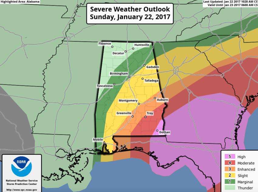
In the MARGINAL RISK area: an isolated severe thunderstorm is possible with damaging wind or large hail.
In the SLIGHT RISK area: a few severe thunderstorms are possible, damaging winds and hail the main threat, an isolated tornado possible
In the MODERATE RISK area: numerous severe thunderstorm are possible, with damaging winds, hail and a higher chance of tornadoes, including some EF2 or stronger tornadoes.
In the HIGH RISK area Widespread severe storms, damaging wind and hail reports and large and dangerous tornadoes are possible. This is limited to only extreme Southeast Alabama around Dothan into Georgia and North Florida, where a significant outbreak of tornadoes is expected.
A tornado watch (another PDS or Particularly Dangerous Situation) has been issued for areas from Troy to Auburn and Eufaula until 7 p.m. Tornado watches now cover a large area from Atlanta to Mobile to Jakconsville.
Category: Alabama's Weather
About the Author (Author Profile)
Bill Murray is the President of The Weather Factory. He is the site's official weather historian and a weekend forecaster. He also anchors the site's severe weather coverage. Bill Murray is the proud holder of National Weather Association Digital Seal #0001 @wxhistorianSubscribe
If you enjoyed this article, subscribe to receive more just like it.


