

Cold Rain Tomorrow Night; Colder Sunday
**No afternoon Weather Xtreme video today… I am writing this from Chicago where I will be speaking at a couple of weather events this weekend**
BIG WEEKEND WEATHER CHANGES: We have a big temperature contrast across Alabama this afternoon; places like Tuscaloosa and Montgomery are up in the 70s, but to the north they are barely out of the 50s at Cullman. The sky is mostly sunny, and there is no rain on radar.
Tonight will be fair and colder; most places will drop into the mid 30s early tomorrow morning.
FROST ADVISORY FOR NORTH AND NORTH CENTRAL ALABAMA
The NWS has issued a frost advisory for several counties in North and Central Alabama for early Saturday morning. Temperatures in the lower and middle will cause frost overnight. Tender vegetation should be protected.
INCREASING CLOUDS SATURDAY
Clouds will move in quickly tomorrow, and rain becomes widespread tomorrow night as a wave of low pressure moves into the state from the west. Tomorrow will be a cooler day with a high in the mid 50s, and as the rain falls tomorrow night temperatures will be in the 40s, so no worries with severe storms. The main window for rain will come from 6:00 p.m. tomorrow through 8:00 a.m. Sunday, and rain amounts of around 1/2 inch are likely.
SNOW FOR FAR NORTH ALABAMA: As colder air invades the state, the rain should change over to light snow over the Tennessee Valley of North Alabama early Sunday morning. Up to 1/2″ is possible over the extreme northern part of Alabama by mid morning Sunday, especially north of the Tennessee River, and across higher terrain.
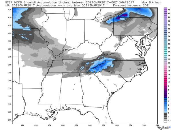
With temperatures falling below freezing early Sunday, some icy spots are certainly possible across far North Alabama, and into Tennessee where some spots could see over one inch of snow. Icy spots won’t last too long as temperatures rise above freezing by mid to late morning.
During the day Sunday, we expect gradual clearing with a high in the mid 50s across North/Central Alabama.
NEXT WEEK: An Alberta Clipper will bring clouds back to Alabama Monday along with a chance of light rain during the afternoon and evening hours… then even colder air blows into the state Tuesday. We could see a few snow flurries over North Alabama early Tuesday morning, and the high will be only in the mid 40s.
A significant freeze is likely by early Wednesday with temperatures dropping into the mid 20s… colder spots could actually see upper teens. A warming trend begins Thursday, and by Friday highs should be back in the 60s. For now the latter half of the week looks dry.
Click here to see the Beach Forecast Center page. Save Up To 25% on Spring Break Beach Vacations on the Alabama Gulf Coast with Brett/Robinson! The Beach Forecast is partially underwritten by the support of Brett/Robinson Vacation Rentals in Gulf Shores and Orange Beach. Click here to see Brett/Robinson’s best beach offers now!.
WEATHER BRAINS: Don’t forget you can listen to our weekly 90 minute netcast anytime on the web, or on iTunes. This is the show all about weather featuring many familiar voices, including our meteorologists here at ABC 33/40.
CONNECT: You can find me on all of the major social networks…
Facebook
Twitter
Google Plus
Instagram
Pinterest
Snapchat: spannwx
Look for my next Weather Xtreme video here by 7:00 a.m. Monday… Brian Peters will have the video updates tomorrow and Sunday. And, don’t forget the time change; we go back on DST Sunday morning. Enjoy the weekend!
Category: Alabama's Weather, ALL POSTS
About the Author (Author Profile)
James Spann is one of the most recognized and trusted television meteorologists in the industry. He holds the AMS CCM designation and television seals from the AMS and NWA. He is a past winner of the Broadcast Meteorologist of the Year from both professional organizations.Subscribe
If you enjoyed this article, subscribe to receive more just like it.


