

A Rather Chilly Pattern for Us
Interesting and somewhat complex forecast shaping up for the next week for us. A frost advisory was in effect for about the northern third of Alabama for this morning, and it expired at 7:00 am.
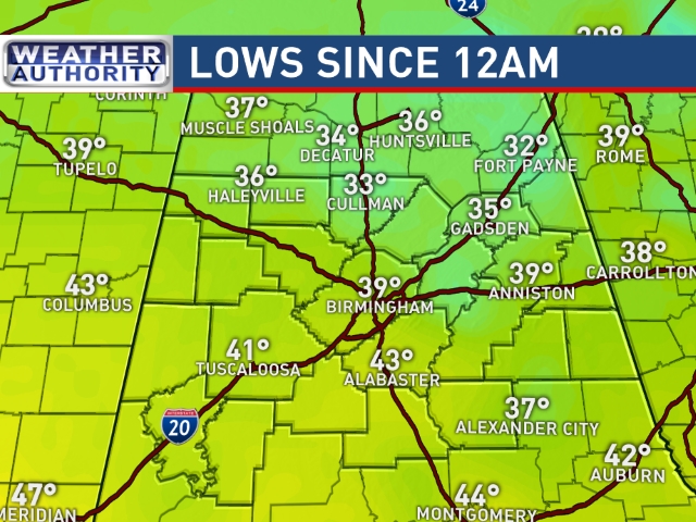
The latest satellite view shows high clouds streaming into Alabama from the west this morning, and clouds will be increasing rapidly during the late morning and early afternoon. Showers become a possibility late this afternoon and into the evening. The highs today will reflect the much colder air which has settled into the Southeast US with readings in the lower 50s, and those are about 20 degrees colder than yesterday. One of the most common questions I have been getting recently is whether or not winter is over. I think the weather for the next week will provide a resounding no in answer to that question.
If you have plans for some beach-time, rain and storms are in the forecast through Sunday with some showers continuing into Monday. The rest of the week looks dry. Highs will be mainly in the 60s. Lows will be mostly in the 50s except Wednesday and Thursday mornings when lows near 40 will be typical.
Click here to see the Beach Forecast Center page. Save Up To 25% on Spring Break Beach Vacations on the Alabama Gulf Coast with Brett/Robinson! The Beach Forecast is partially underwritten by the support of Brett/Robinson Vacation Rentals in Gulf Shores and Orange Beach. Click here to see Brett/Robinson’s best beach offers now!.
A weak short wave trough will move out of Texas and along the Gulf Coast on Sunday along with a weak surface low providing some wet weather for tonight and into Sunday morning. The coldest air is expected to remain north of Central Alabama but some light snow is forecast to occur in the Alabama counties right along the state line with Tennessee. Winter weather advisories have been issued for portions of eastern and Middle Tennessee and northern Georgia. Amounts will be light with generally less than an inch forecast so no serious travel impacts are forecast due in part to the warm ground. While clouds will stick around during the day Sunday, rain chances are expected to drop off by the latter part of the afternoon and into the evening hours for Central Alabama. Highs will be in the 50s.
Late Monday and into early Tuesday, a short wave digs into the eastern US reinforcing the cold weather and bringing another shot of precipitation for Monday. Highs Monday and Tuesday will be in the 50s. There is a possibility that the highs on Tuesday may not climb out of the upper 40s. This will depend on the exact timing of the passage of the short wave and the cold front. Certainly right now the data suggests a rather cold and bitter day for Tuesday with a strong northwest wind to help make it feel even colder.
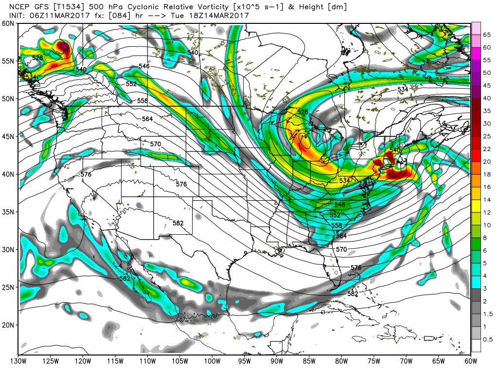
Tuesday we dry out as the upper trough becomes enhanced along the East Coast. We could see some snow flurries with the moisture wrapping around the surface low along the Mid-Atlantic States. The troughiness remains in place along the East Coast through Thursday, so Wednesday we will probably remain pretty cold and the GFS is currently projecting a high of 46 on Wednesday. It might not feel as cold as Tuesday because the wind should be diminishing.
Weak ridging aloft takes hold on Thursday and Friday as our highs will bounce back into the 50s and 60s. But another strong short wave drops into the Central US Friday and becomes a closed low over Middle Tennessee on Saturday. This brings the wet weather back again on Friday and Saturday. With the strong closed low aloft, the GFS is wringing out some snow once again Saturday night and early Sunday mainly in Tennessee, however, it does catch a portion of the Tennessee River Valley. This is verging on voodoo country, so it is much too early to try to predict snowfall amounts. For Central Alabama out temperatures will be close to seasonal averages with highs in the 60s and lows around 40.
Looking out into voodoo country, the closed low moves off the Southeast US coast by Monday paving the way for the upper ridge to build back into the Southeast US. Another upper trough swings across the Central US on March 23rd. Following quickly on that one is another relatively low latitude closed low coming at the Lower Mississippi River Valley on March 26th. The GFS is certainly keeping the pattern active and busy.
I plan to have the next Weather Xtreme Video posted here first thing on Sunday morning. Remember, Daylight Saving Time starts tonight when we set our clocks ahead one hour at 2 am. I had a great time at the Career Fair in Sumiton yesterday. There sure are a lot of 8th graders in Walker County and it was a pleasure to introduce them to various aspects of a career in meteorology. Enjoy your day and Godspeed.
-Brian-

Category: Alabama's Weather, ALL POSTS
About the Author (Author Profile)
Brian Peters is one of the television meteorologists at ABC3340 in Birmingham and a retired NWS Warning Coordination Meteorologist. He handles the weekend Weather Xtreme Videos and forecast discussion and is the Webmaster for the popular WeatherBrains podcast.Subscribe
If you enjoyed this article, subscribe to receive more just like it.


