

Professor Peters’ Weather 101: Nor’Easters
If you are a regular reader of the blog, you might well qualify as a weather nerd – and this term is used fondly and not in a derogatory way. So you’ve probably been hearing lots of traffic about the nor’easter that is expected tonight and Tuesday to affect the northeastern portion of the US from the Mid-Atlantic states into New England. So just what is a nor’easter?
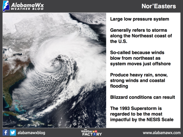
The term nor’easter – meaning northeaster – refers to a large scale low pressure system or cyclone. While the term can be applied anywhere that your experience a northeasterly flow, the term applies mainly to cyclones affecting New England. The name originates because of the strong wind that generally blows from the northeast as a strong cyclone moves just offshore from the New England states. The counterclockwise flow around the low pressure center generates the strong northeast wind flow over a fairly broad area.
Formation of these storms typically takes place just offshore – typically about 100 miles – in the area between North Carolina and Massachusetts. But formation of these storms can take place as far south as the Gulf of Mexico just as long as the low pressure center remains offshore in order to produce a strong northeasterly wind over New England.
In addition to the strong wind, these storms are typically accompanied by very heavy rain or snow and can produce severe coastal flooding, coastal erosion, wind approaching hurricane force, and blizzard conditions. In fact, a blizzard watch was in effect for a serious chunk of the coastline from New York City to Boston on Sunday, March 12th.
The term nor’easter has a very long history with its origin having been traced back to the late 1500s and early 1600s though there appears to be a good deal of debate on this topic.
Nor’easters develop in part to the sharp contrast in the warm Gulf Stream ocean current coming up from the tropical Atlantic and the cold air masses riding down from Canada. When the very cold and dry air rushes southward and meets the warm air over the Gulf stream current, which is often near 70 °F even in mid-winter, intense low pressure develops. Aloft, the strong wind of the jet stream removes and replaces rising air from the Atlantic more rapidly than the Atlantic air is replaced at lower levels. Together with the help of the Coriolis force, a strong storm can develop. Model projections on Sunday, March 12th, placed the lowest pressure of the storm at 986 millibars as the storm center was passing offshore from the coast of Maine.
Another interesting aspect to the observation of our atmosphere. If you have a question about the weather, drop an email to question at weather brains dot com and the team over there will try to answer it for you.
Category: ALL POSTS, Met 101/Weather History
About the Author (Author Profile)
Bill Murray is the President of The Weather Factory. He is the site's official weather historian and a weekend forecaster. He also anchors the site's severe weather coverage. Bill Murray is the proud holder of National Weather Association Digital Seal #0001 @wxhistorianSubscribe
If you enjoyed this article, subscribe to receive more just like it.


