

Storms Over Etowah and Cherokee Counties Into Georgia Now
The storms that were over Etowah and Cherokee Counties are now into Georgia. The watch will be canceled soon.
ORIGINAL POST
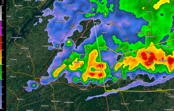
At 735 p.m., the storms over Etowah and Cherokee Counties appear to be weaker. They extend from north of Hoke’s Bluff east along US-411 through Centre and Forney.
They are pushing east southeast at 45 mph.
Gusty winds, heavy rain and some small hail will accompany them. The lightning has really dropped in the past 15 minutes.
Wind damage was reported across Cherokee County, including traffic lights downed in Leesburg and a couple of large trees blown down in Gaylesville and near Yellow Creek Falls. Winds were estimated at 45-50 mph.
Notice the large severe thunderstorm warning in western Georgia.
Category: Alabama's Weather, ALL POSTS
About the Author (Author Profile)
Bill Murray is the President of The Weather Factory. He is the site's official weather historian and a weekend forecaster. He also anchors the site's severe weather coverage. Bill Murray is the proud holder of National Weather Association Digital Seal #0001 @wxhistorianSubscribe
If you enjoyed this article, subscribe to receive more just like it.


