

Strong/Severe Storms Possible Saturday
VERY NICE SPRING DAY: With ample sunshine, temperatures are above 70 degrees across most of Alabama this afternoon. The humidity is low, and there is no rain on radar. Tonight will be mostly fair with a low in the 50s.
We stay dry tomorrow with a partly sunny sky and a high back in the 70s. To the west we will be keeping an eye an upper trough moving out of the Rockies that will bring a severe weather threat to places like Dallas, Tulsa, Little Rock, and Shreveport.
STORMY SATURDAY: A surface low, supported by an upper trough, will be over Missouri, and Alabama will be in a moist, unstable airmass. SPC has roughly the western half of the state in the standard “slight risk” of severe storms, with a “marginal risk” over East Alabama…
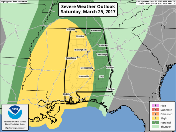
TIMING: While showers are possible Saturday morning, the primary severe weather threat will come from roughly 12:00 noon Saturday until 9:00 p.m.
THREATS: The main issue will come from strong, potentially damaging straight line winds along a squall line. Seems like the weather parameters (shear, low level jet, instability) are a little out of phase for a big tornado threat, but an isolated tornado or two is possible. Also, heavier storms could produce hail Saturday.
RAIN: Rain amounts should be in the 1/2 to 1 inch range; flooding is not expected.
Any leftover showers should end early Sunday, and the sky becomes partly sunny by Sunday afternoon. Highs over the weekend will be in the 70s.
ACTIVE PATTERN SETTING UP: Sure looks like we have a fairly busy weather pattern for the next few weeks. Another surface low will be over Missouri Monday, and once again that could bring strong to severe storms to the state. Drier air returns for Tuesday and mid-week, another setup for strong storms will return late in the week Friday. And, yet another one shows up in medium range guidance around Sunday April 2. Like a football coach, we will just take these storm systems one at a time… once we get past Saturday we can focus on Monday. See the Weather Xtreme video for maps, graphics, and more details.
Click here to see the Beach Forecast Center page. Save Up To 25% on Spring Break Beach Vacations on the Alabama Gulf Coast with Brett/Robinson! The Beach Forecast is partially underwritten by the support of Brett/Robinson Vacation Rentals in Gulf Shores and Orange Beach. Click here to see Brett/Robinson’s best beach offers now!.
STORM SPOTTER TRAINING IN GARDENDALE TONIGHT: We will be on the road through early April offering free storm spotter classes. We need more trained spotters in Alabama; by attending you can make the severe weather warning process better. No need to register; just come with a curious mind. And, there is no age limit… kids that love weather will enjoy it. You will never look at a storm the same again. The next class is this evening at the Gardendale Civic Center at 6:30.
WEATHER BRAINS: Don’t forget you can listen to our weekly 90 minute netcast anytime on the web, or on iTunes. This is the show all about weather featuring many familiar voices, including our meteorologists here at ABC 33/40.
CONNECT: You can find me on all of the major social networks…
Facebook
Twitter
Google Plus
Instagram
Pinterest
Snapchat: spannwx
I enjoyed seeing the students with New Hope Christian Homeschool in Haleyville this morning, along with the second graders at Haleyville Elementary School. Be looking for them on the Pepsi KIDCAM today at 5:00 and 6:00 on ABC 33/40 News! The next Weather Xtreme video will be posted here by 7:00 a.m. tomorrow…
Category: Alabama's Weather, ALL POSTS
About the Author (Author Profile)
James Spann is one of the most recognized and trusted television meteorologists in the industry. He holds the AMS CCM designation and television seals from the AMS and NWA. He is a past winner of the Broadcast Meteorologist of the Year from both professional organizations.Subscribe
If you enjoyed this article, subscribe to receive more just like it.


