

Severe Thunderstorm Warning Continues For Parts Of Dekalb County Until 7:30PM

…A SEVERE THUNDERSTORM WARNING REMAINS IN EFFECT UNTIL 730 PM CDT FOR SOUTHEASTERN DEKALB COUNTY… At 717 PM CDT, a severe thunderstorm was located over Fort Payne, moving northeast at 40 mph. Trees and power lines were reported downed with this storm earlier in Collinsville.
HAZARD…60 mph wind gusts and quarter size hail.
SOURCE…Radar indicated.
IMPACT…Hail damage to vehicles is expected. Expect wind damage to roofs, siding, and trees. Locations impacted include… Fort Payne, Little River Canyon National Preserve, Little River Falls, Valley Head, Hammondville, Pine Ridge, Little River Canyon Np, Adamsburg and Desoto State Park.
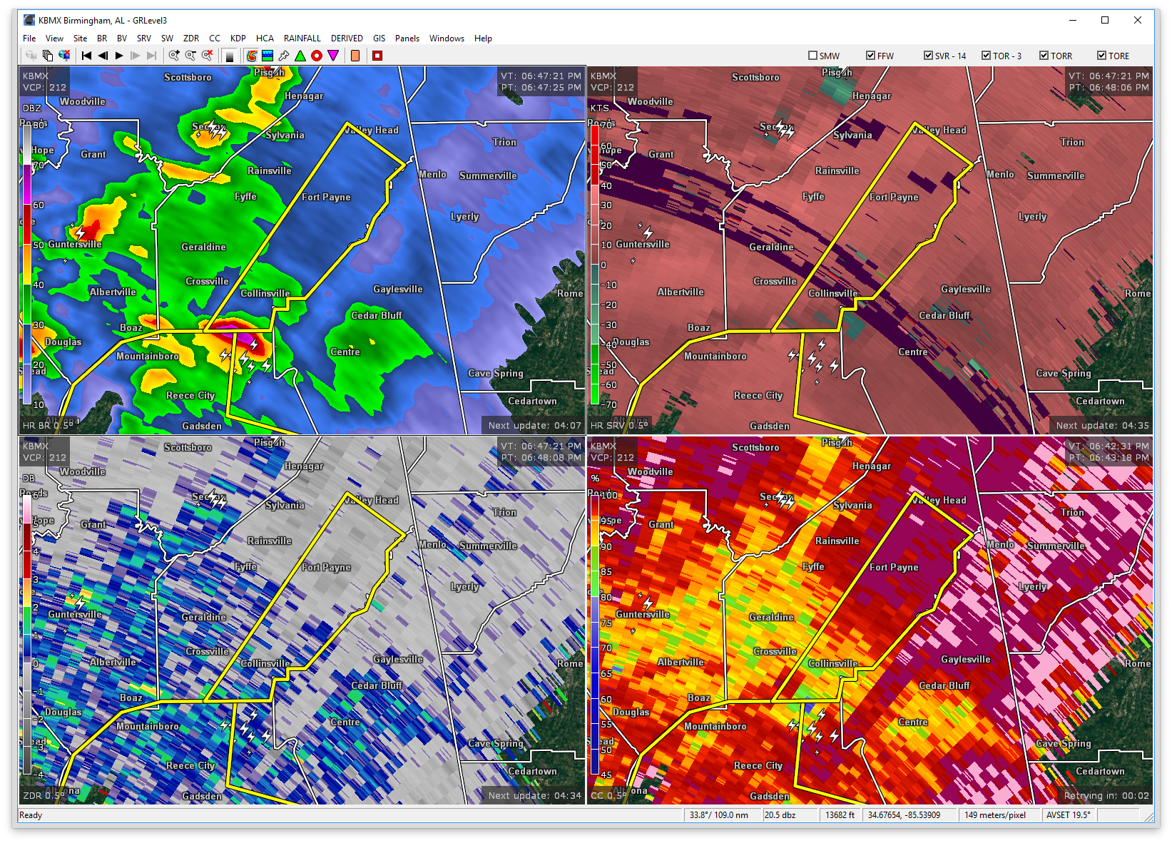
Severe Thunderstorm Warning Continues For Parts Of Dekalb County Until 7:30PM
Mar 27th @ 6:47 pm

…A SEVERE THUNDERSTORM WARNING REMAINS IN EFFECT UNTIL 730 PM CDT FOR SOUTHEASTERN DEKALB COUNTY… At 707 PM CDT, a severe thunderstorm was located 7 miles north of Sand Rock, or 7 miles south of Fort Payne, moving northeast at 40 mph.
HAZARD…60 mph wind gusts and quarter size hail.
SOURCE…Radar indicated.
IMPACT…Hail damage to vehicles is expected. Expect wind damage to roofs, siding, and trees. Locations impacted include… Fort Payne, Little River Canyon National Preserve, Little River Falls, Valley Head, Hammondville, Pine Ridge, Collbran, Dog Town, Little River Canyon Np and Lebanon.
Severe Thunderstorm Warning Issued For Parts Of Dekalb County Until 7:30PM
Mar 27th @ 6:47 pm

The National Weather Service in Huntsville Alabama has issued a
* Severe Thunderstorm Warning for…
Southeastern DeKalb County in northeastern Alabama…
* Until 730 PM CDT
* At 647 PM CDT, a severe thunderstorm was located over Tabor Road, or 13 miles west of Centre, moving northeast at 40 mph.
HAZARD…60 mph wind gusts and quarter size hail.
SOURCE…Radar indicated.
IMPACT…Hail damage to vehicles is expected. Expect wind damage to roofs, siding, and trees.
* Locations impacted include…
Fort Payne, Little River Canyon National Preserve, Collinsville, Little River Falls, Valley Head, Hammondville, Pine Ridge, Collbran, Dog Town and Little River Canyon Np.
Category: ALL POSTS, Archived Warnings
About the Author (Author Profile)
Subscribe
If you enjoyed this article, subscribe to receive more just like it.


