

Beautiful Weekend; Rain/Storms Return Monday
DRY THROUGH THE WEEKEND: For the northern half of Alabama yesterday, severe weather was a no show, thanks to a batch of storms that moved through the southern two-thirds of the state during the morning, cutting off the southerly flow and making the atmosphere relatively stable. There was some minor damage, however, in counties like Cullman due to non-thunderstorm winds related to a wake low/gravity wave on the back side of departing rain.
The weather will be dry and pleasant today through the weekend.. The high this afternoon will be in the mid 70s, followed by upper 70s tomorrow with a sunny sky both days. Sunday will be a partly sunny day with a high in the low 80s. Clouds will increase Sunday night, however, ahead of the next wave, and some rain could reach West Alabama late Sunday night.
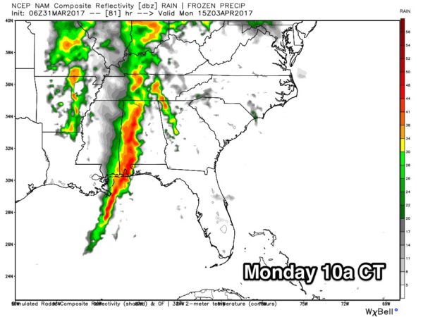
WET DAY MONDAY: We will highlight rain and thunderstorms statewide Monday; guidance hints there won’t be much instability to work with, and the main impact will be heavy rain as opposed to a severe weather threat. For now SPC has not defined any severe weather threat; better chance of stronger storms Monday will be over the southern half of the state. Rain amounts could exceed one inch in spots.
REST OF NEXT WEEK: The next system in the “wave train” will bring another round of rain and storms to Alabama late Wednesday, Wednesday night, and into early Thursday, but for now the parameters don’t look especially favorable for severe storms. Dry and colder air settles in by the end of the week, and I wouldn’t be shocked if we wind up with lows in the 30s Friday morning (April 7). This could be the late season cold snap we almost always have in April. Because of this every year I recommend that people hold off planting anything that will be harmed by a freeze until April 15.
Click here to see the Beach Forecast Center page. Save Up To 25% on Spring Break Beach Vacations on the Alabama Gulf Coast with Brett/Robinson! The Beach Forecast is partially underwritten by the support of Brett/Robinson Vacation Rentals in Gulf Shores and Orange Beach. Click here to see Brett/Robinson’s best beach offers now!.
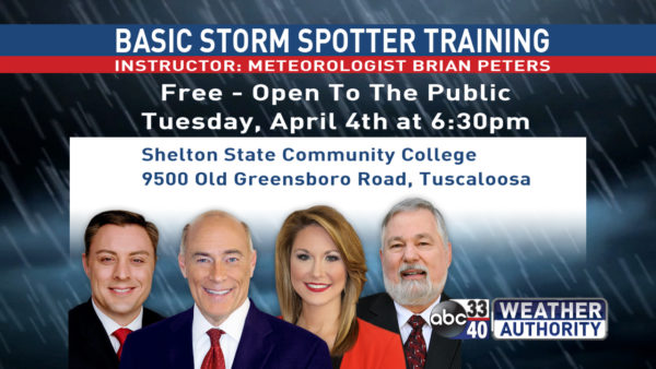
STORM SPOTTER TRAINING: We will be on the road through April offering free storm spotter classes. We need more trained spotters in Alabama; by attending you can make the severe weather warning process better. No need to register; just come with a curious mind. And, there is no age limit… kids that love weather will enjoy it. You will never look at a storm the same again. The next training is in Tuscaloosa Tuesday evening (April 4) at 6:30 at Shelton State Community College.
WEATHER BRAINS: Don’t forget you can listen to our weekly 90 minute netcast anytime on the web, or on iTunes. This is the show all about weather featuring many familiar voices, including our meteorologists here at ABC 33/40.
CONNECT: You can find me on all of the major social networks…
Facebook
Twitter
Google Plus
Instagram
Pinterest
Snapchat: spannwx
I will be speaking this morning at Hillcrest High School in Tuscaloosa… look for the next Weather Xtreme video here by 4:00 this afternoon. Enjoy the day!
Category: Alabama's Weather, ALL POSTS
About the Author (Author Profile)
James Spann is one of the most recognized and trusted television meteorologists in the industry. He holds the AMS CCM designation and television seals from the AMS and NWA. He is a past winner of the Broadcast Meteorologist of the Year from both professional organizations.Subscribe
If you enjoyed this article, subscribe to receive more just like it.


