A Few Notes About Wednesday
We will be watching new model data pouring in over the next few hours, with the highest interest in developments Wednesday, when severe thunderstorms are possible statewide.
No doubt the synoptic scale suggests it could be a big severe day, with a deep surface low northwest of Alabama supported by an upper trough with strong wind fields. As usual, the devil will be in the details.
We expect a batch of early morning storms as a warm front moves northward; generally in the 4-10 a.m. time frame. These, most likely, will be elevated, with the main risk coming from strong straight line winds and hail. But, this is the first week in April, and we will have to watch for any surprises. Should the morning storms be rooted in the boundary layer, there could be a tornado or two.
But, the main action should come during the afternoon and evening hours, generally between 2:00 p.m. and 7:00 p.m. The one thing that really sticks out is the very high surface based instability; some model guidance suggests surface based CAPE values could exceed 4,000 j/kg by mid-afternoon…
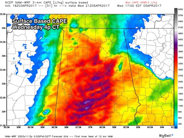
This will create a “power keg” type atmosphere with high buoyancy with little in the way of a capping inversion. Storms should explode during the peak of the daytime heating process, and based on forecast parameters such as bulk shear, lapse rates, and the lack of convective inhibition, the storms are expected to become severe quickly, with all modes of severe weather possible, including tornadoes. And, maybe even a strong/violent tornado or two.
I would imagine the guys at SPC will put parts of the state under a “moderate risk” (4 out of 5) on their new outlook that comes out later tonight. One way or another, it looks like an active day with potentially dangerous storms.
PLACEMENT: Seems like the best combination of shear and instability will come over the eastern two-thirds of Alabama, but the entire state will see some risk of severe storms.
It is important to note we really don’t know how the morning storms will impact the state of the atmosphere, and exactly how the parameters will phase up during the afternoon. But, considering the time of the year and the setup, we all need to pay attention.
There is no need to be anxious, or overly concerned now, but just prepare.
CALL TO ACTION: Be sure you have a way of getting warnings; a NOAA Weather Radio is the baseline, and a good smart phone app is the other tier. Identify the safe place in your home, and be sure everyone knows where it is. And, in that safe place have helmets for everyone, along with hard sole shoes and preferably a portable airhorn in case you need help.
Be sure you have the ABC 33/40 app on your phone so you can watch our live severe weather coverage, if needed:
I will have new discussion and Weather Xtreme video posted bright and early tomorrow morning… stay tuned.
Category: Alabama's Weather, ALL POSTS
About the Author (Author Profile)
James Spann is one of the most recognized and trusted television meteorologists in the industry. He holds the AMS CCM designation and television seals from the AMS and NWA. He is a past winner of the Broadcast Meteorologist of the Year from both professional organizations.Subscribe
If you enjoyed this article, subscribe to receive more just like it.


