

Severe Weather Watch May Be Issued
SUMMARY…Damaging wind gusts and hail approaching 1″ in diameter are all possible with storms developing across the region this afternoon.
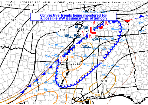
DISCUSSION…Scattered thunderstorms are continuing to increase across the discussion area just ahead of a surface boundary extending from Middle Tennessee, through the Mississippi Delta, and southwestward into northern Louisiana. The airmass ahead of this frontal boundary was weakly capped, with insolation/surface warming and weak low-level warm advection fostering weak to moderate instability in an axis from central Louisiana northeastward to Middle Tennessee. Stronger instability was common in southwestern portions of the discussion area (1500-2000 J/kg MUCAPE), with gradually weaker instability (500 J/kg MUCAPE) area near Nashville. Westerly deep shear (around 35 knots) was sufficient for storm organization, and weak surface convergence combined with ascent associated with a mid-level low north of the area should foster gradually increasing convective coverage and intensity with progression toward peak heating later this afternoon. Hail and gusty winds will be the primary threats with this activity. Given the aforementioned scenario, a watch issuance is being considered for portions of the region. Probability of Watch Issuance…40 percent.
Stay weather aware this afternoon and evening!
About the Author (Author Profile)
Macon, Georgia Television Chief Meteorologist, Birmingham native, and long time Contributor on AlabamaWX. Stormchaser. I did not choose Weather, it chose Me. College Football Fanatic. @Ryan_StinnetSubscribe
If you enjoyed this article, subscribe to receive more just like it.


