

Severe Thunderstorm Warning Expired For Parts Of Etowah And St. Clair Counties
…THE SEVERE THUNDERSTORM WARNING FOR EASTERN ETOWAH AND CENTRAL ST.
CLAIR COUNTIES WILL EXPIRE AT 345 AM CDT…
The storms which prompted the warning have weakened below severe
limits, and have exited the warned area. Therefore the warning will
be allowed to expire.
Severe Thunderstorm Warning Continues For Parts Of Etowah And St. Clair Counties Until 3:45AM
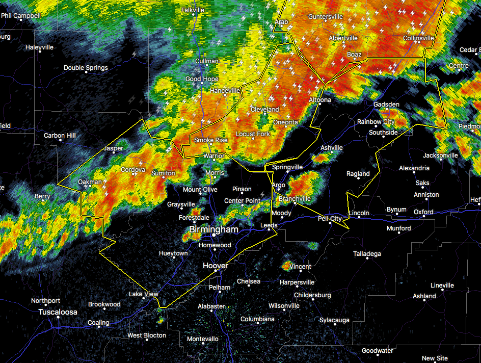
May 28th @ 2:47 am

…A SEVERE THUNDERSTORM WARNING REMAINS IN EFFECT UNTIL 345 AM CDT FOR EASTERN ETOWAH AND CENTRAL ST. CLAIR COUNTIES… At 328 AM CDT, severe thunderstorms were located along a line extending from near Pell City to 6 miles northeast of Ohatchee to Ballplay, moving east at 40 mph.
HAZARD…60 mph wind gusts.
SOURCE…Radar indicated.
IMPACT…Expect damage to roofs, siding, and trees. Locations impacted include… Gadsden, Pell City, Rainbow City, Hokes Bluff, Springville, Odenville, Lincoln, Glencoe, Margaret, Argo, Ashville, Riverside, Ragland, Reece City, Tabor Road, Branchville, Ballplay, Gadsden Mall, Noccalula Falls and Southside.
Severe Thunderstorm Warning Continues For Parts Of Etowah And St. Clair Counties Until 3:45AM
May 28th @ 2:47 am

…A SEVERE THUNDERSTORM WARNING REMAINS IN EFFECT UNTIL 345 AM CDT FOR ETOWAH AND ST. CLAIR COUNTIES… At 305 AM CDT, severe thunderstorms were located along a line extending from near Springville to Steele to near Crossville, moving east at 50 mph.
HAZARD…70 mph wind gusts.
SOURCE…Radar indicated.
IMPACT…Expect considerable tree damage. Damage is likely to mobile homes, roofs, and outbuildings. Locations impacted include… Gadsden, Pell City, Rainbow City, Hokes Bluff, Springville, Odenville, Lincoln, Attalla, Glencoe, Margaret, Argo, Ashville, Riverside, Sardis City, Ragland, Steele, Altoona, Walnut Grove, Reece City and Aurora.
Severe Thunderstorm Warning Issued For Parts Of Etowah And St. Clair Counties Until 3:45AM
May 28th @ 2:47 am

The National Weather Service in Birmingham has issued a
* Severe Thunderstorm Warning for…
Etowah County in northeastern Alabama…
St. Clair County in Alabama…
* Until 345 AM CDT
* At 246 AM CDT, severe thunderstorms were located along a line extending from County Line to near Rosa to near Guntersville, moving east at 50 mph.
HAZARD…70 mph wind gusts.
SOURCE…Radar indicated.
IMPACT…Expect considerable tree damage. Damage is likely to mobile homes, roofs, and outbuildings.
* Locations impacted include…
Gadsden, Pell City, Rainbow City, Hokes Bluff, Springville, Odenville, Lincoln, Attalla, Glencoe, Margaret, Argo, Ashville, Riverside, Sardis City, Ragland, Steele, Altoona, Walnut Grove, Reece City and Aurora.
Category: ALL POSTS, Archived Warnings
About the Author (Author Profile)
Subscribe
If you enjoyed this article, subscribe to receive more just like it.


