

Wet and Showery in Week Ahead
The GFS model run yesterday morning sure missed those thunderstorms settling south overnight. But the HRRR picked up on that idea during its runs yesterday afternoon. The thunderstorms occurring during the day yesterday along the TN-KY line managed to propagate southward overnight resulting in a rather fierce looking line of thunderstorms settling across the northern half of Alabama through early this morning. Rainfall amounts were not particularly high. The Tennessee Valley stations seemed to get the highest amounts with many airport locations reporting around or slightly above a half inch. In Central Alabama, most locations had reported amounts less than a quarter of an inch.
So this morning is going to be wet. Numerous thunderstorms were occurring across northern Alabama and northern Mississippi while the line of storms had decayed significantly to a very narrow line laying across Central Alabama from just south of Heflin to near Jamison to Eutaw. Behind that thin line were numerous showers and storms including a very large cluster of storms centered in the vicinity of Memphis. While the line continued to progress slowly southward, the storms across northern Mississippi and northern Alabama were moving generally east-northeastward. Clouds from these storms covered the northern half of the state with temperatures mainly in the 60s. Even with the clouds I expect temperatures to warm into the lower 80s and we can expect to see additional showers and storms this morning and throughout the afternoon.
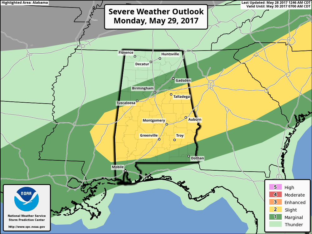
While the frontal system lies well north of us today, it will settle into Central Alabama on Monday as the upper air pattern gradually becomes a broad trough over the eastern part of the country. Clouds and off and on showers and storms should keep temperatures in the lower and middle 80s. And it’s not likely to rain all day with passing storms from time-to-time. SPC does have the standard slight risk posted for a sizable swath of Central and South Alabama on Monday, Day 2. Greatest threat of damaging wind and large hail is expected to come during the afternoon as instability is aided by afternoon heating.
There’s very little change in the upper air pattern on Tuesday, so I expect a repeat of Monday with numerous passing showers and storms. Temperatures are likely to reach the lower 80s. Monday and Tuesday appear to be the days with the best chances for showers and storms.
While the upper air pattern begins to lose the troughiness by Wednesday and Thursday, the old frontal boundary is going to remain in the area, so you can expect to see scattered showers and storms driven primarily by afternoon heating. Weak ridging aloft will closeout the week and take us into the weekend, but with the moist atmosphere in place, scattered showers and storms will continue each day as highs climb into the upper 80s. Precipitable water values remain quite high with amounts from 1.75 inches to 2 inches.
Rainfall amounts are not forecast to be especially high with 5-day amounts across Central Alabama expected to in the rain of 1 to 1.5 inches. Previous rains have really knocked the drought conditions down across Alabama, but we can continue to use whatever rain we get as we are about to verge on the summer months where rain comes from scattered showers.
SEC BASEBALL: The SEC Baseball Tournament winds up today at the Hoover Met with the championship game. Come see some of the best college players in the country as they compete for the championship. Also, for the first time ever, you can take advantage of the Hoover Metropolitan Complex which will feature a free, indoor Fan Fest – ferris wheel, sports bar and much more! Tickets start at only $9! We expect another warm day at the Hoover Met today with highs in the 80s along with a small risk of showers this afternoon. Sunday’s high will be between 85 and 88.
Click here to see the Beach Forecast Center page. Save Up To 25% on Spring Break Beach Vacations on the Alabama Gulf Coast with Brett/Robinson! The Beach Forecast is partially underwritten by the support of Brett/Robinson Vacation Rentals in Gulf Shores and Orange Beach. Click here to see Brett/Robinson’s best beach offers now!
James Spann is expected back with the next Weather Xtreme Video on Monday, however with it being a holiday weekend, he’s likely to produce only one video with additional forecast notes for the afternoon. I hope that you have a great day and great holiday whatever your plans may be. Godspeed.
-Brian-
Category: Alabama's Weather, ALL POSTS
About the Author (Author Profile)
Brian Peters is one of the television meteorologists at ABC3340 in Birmingham and a retired NWS Warning Coordination Meteorologist. He handles the weekend Weather Xtreme Videos and forecast discussion and is the Webmaster for the popular WeatherBrains podcast.Subscribe
If you enjoyed this article, subscribe to receive more just like it.


