

Three Moving North Northwest Across the Gulf of Mexico
Our tropical disturbance remains rather disorganized tonight across the southern Gulf of Mexico some 400 miles south of New Orleans. It has top winds of 40 mph but still has not developed an organized circulation yet.
It continues to encounter strong southwesterly wind shear that is tearing the tops off the thunderstorms. The low level center is still exposed tonight.
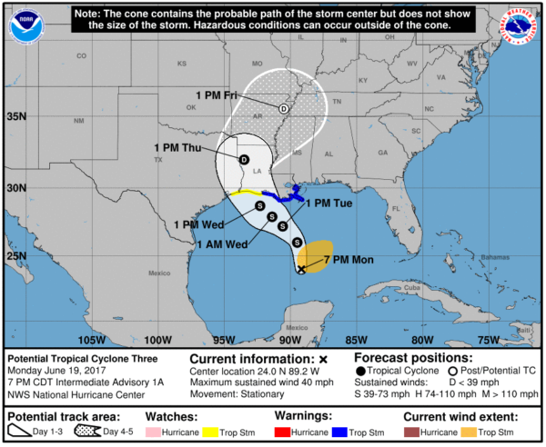
Even though Three is disorganized, it still is expected to become a tropical storm soon as the upper low begins to weaken to the northwest of Three. If it does, it will be called Cindy. Water temperatures in the Gulf are warm and oceanic heat content high enough to support continued development.
The future track of Three/Cindy is not totally certain. If the upper low is able to exert more influence, the cyclone will turn more northwest, perhaps heading toward the Houston area. A more rapid weakening of the upper low may result in a stronger cyclone and more of a track toward the Central Louisiana coast.
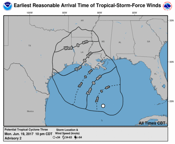
The official NHC track carries it to the southwestern coast of Louisiana between Lake Charles and Morgan City Wednesday afternoon. Tropical storm force winds may reach the southeastern tip of Louisiana Tuesday morning and spread across southern Louisiana and southern Mississippi during the day and into Tuesday night.
A tropical storm warning is in effect from Intracoastal City to the Mouth of the Pearl River, including much of the Central and Southeast Louisiana coast up to the Mississippi state line. A tropical storm watch is in effect for the Southwest Louisiana coast.
Huge waves are building over the Central Gulf of Mexico. These waves will spread onto the Central Gulf Coast starting tomorrow, causing high surf and dangerous rip current. Squally weather will overspread the coasts of Louisiana, Mississippi, Alabama and Florida. Heavy rain will overspread the Gulf Coast from Panama City to Houma LA, dumping 7-10 inches of rain.
HERE IS THE COMPLETE TEXT OF THE 10 PM ADVISORY
…DISTURBANCE MOVING SLOWLY NORTH-NORTHWESTWARD OVER THE CENTRAL
GULF OF MEXICO…
SUMMARY OF 1000 PM CDT…0300 UTC…INFORMATION
———————————————–
LOCATION…24.4N 89.5W
ABOUT 325 MI…525 KM S OF THE MOUTH OF THE MISSISSIPPI RIVER
ABOUT 380 MI…610 KM SSE OF MORGAN CITY LOUISIANA
MAXIMUM SUSTAINED WINDS…40 MPH…65 KM/H
PRESENT MOVEMENT…NNW OR 330 DEGREES AT 8 MPH…13 KM/H
MINIMUM CENTRAL PRESSURE…1000 MB…29.53 INCHES
WATCHES AND WARNINGS
——————–
CHANGES WITH THIS ADVISORY:
None.
SUMMARY OF WATCHES AND WARNINGS IN EFFECT:
A Tropical Storm Warning is in effect for…
* Intracoastal City to the Mouth of the Pearl River
A Tropical Storm Watch is in effect for…
* West of Intracoastal City to High Island
A Tropical Storm Warning means that tropical storm conditions are
expected somewhere within the warning area, in this case within the
next 24 to 36 hours.
A Tropical Storm Watch means that tropical storm conditions are
possible within the watch area, generally within 48 hours.
Interests elsewhere along the U.S. Gulf Coast from the central Texas
coast to the western Florida Panhandle should monitor the progress
of this system.
For storm information specific to your area, including possible
inland watches and warnings, please monitor products issued by your
local National Weather Service forecast office.
DISCUSSION AND 48-HOUR OUTLOOK
——————————
At 1000 PM CDT (0300 UTC), the disturbance was centered near
latitude 24.4 North, longitude 89.5 West. The system is moving
toward the north-northwest near 8 mph (13 km/h). A turn toward the
northwest should occur by Tuesday morning, and that motion is
expected to continue into Wednesday. On the forecast track, the
disturbance is expected to be near the Louisiana coast on
Wednesday.
Maximum sustained winds are near 40 mph (65 km/h) with higher gusts.
Some slight strengthening is possible before the system reaches the
coast.
Upper-level winds are expected to be marginally conducive for some
additional development of this system during the next day or two,
and a tropical or subtropical cyclone is likely to form during that
time.
* Formation chance through 48 hours…high…80 percent
* Formation chance through 5 days…high…80 percent
Tropical-storm-force winds extend outward up to 205 miles (335 km)
to the north and east of the center.
The estimated minimum central pressure is 1000 mb (29.53 inches).
HAZARDS AFFECTING LAND
———————-
WIND: Tropical storm conditions are expected to first reach the
coast within the warning area by Tuesday afternoon. Tropical storm
conditions are possible in the watch area on Wednesday.
RAINFALL: The disturbance is expected to produce total rain
accumulations of 4 to 8 inches with isolated maximum amounts of
10 inches over southeastern Louisiana, southern Mississippi,
southern Alabama, and the Florida Panhandle through Wednesday
evening.
NEXT ADVISORY
————-
Next intermediate advisory at 100 AM CDT.
Next complete advisory at 400 AM CDT.
About the Author (Author Profile)
Bill Murray is the President of The Weather Factory. He is the site's official weather historian and a weekend forecaster. He also anchors the site's severe weather coverage. Bill Murray is the proud holder of National Weather Association Digital Seal #0001 @wxhistorianSubscribe
If you enjoyed this article, subscribe to receive more just like it.


