

Cindy Moving Northwestward Toward The Gulf Coast
Little change has been observed since the last update at 10AM. Cindy is still packing maximum sustained winds at 50 MPH and is moving to the northwest at 9 MPH.
The NWS in Mobile just issued an areal flood warning for twenty of their counties. A few reports from the state have come in where flooding is becoming an issue. Parts of Brewton, especially near Murder and Burnt Corn Creeks, are now under water and levels are rising quickly. We’ve also had a report of 8.02 inches of rain has fallen at Johnson’s Beach in Escambia County.
Sad news to report out of Fort Morgan, as a 10 year old child was struck by some debris and lost his life. This is the first fatality (that we know of) from Cindy.
FAST FACTS AS OF 1 PM
———————————————-
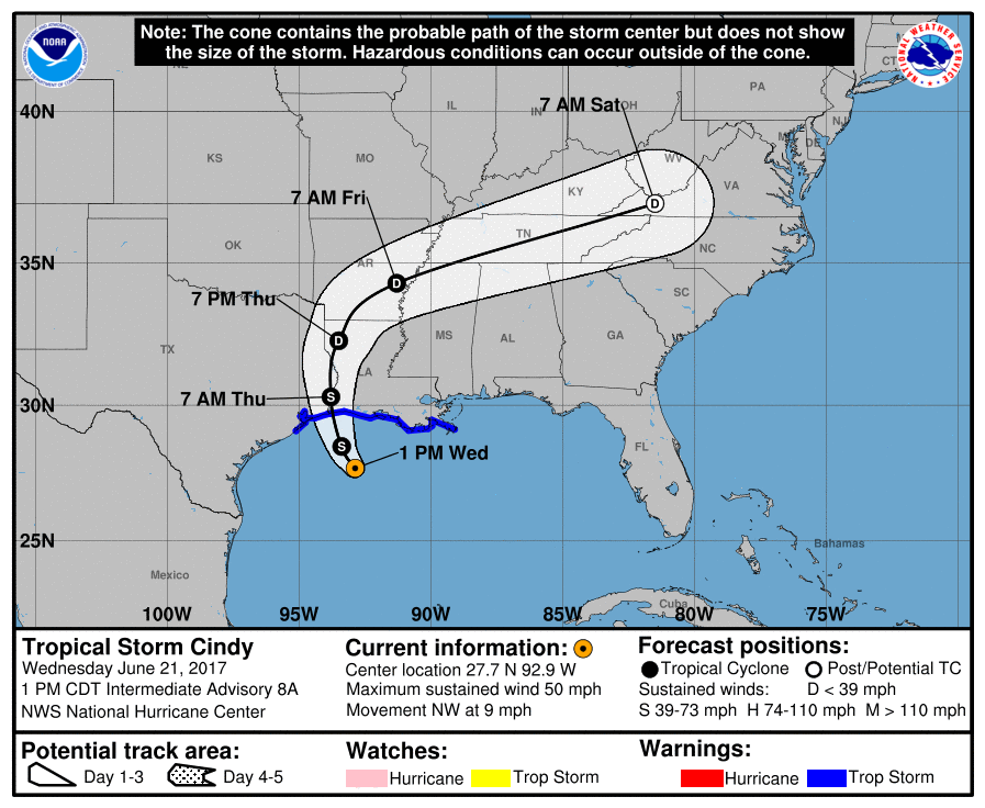
LOCATION…27.7N 92.9W
ABOUT 170 MI…270 KM SW OF MORGAN CITY LOUISIANA
ABOUT 160 MI…255 KM SE OF GALVESTON TEXAS
MAXIMUM SUSTAINED WINDS…50 MPH…85 KM/H
PRESENT MOVEMENT…NW OR 310 DEGREES AT 9 MPH…14 KM/H
MINIMUM CENTRAL PRESSURE…995 MB…29.38 INCHES
Here is the complete text of the rest of the advisory:
Watches And Warnings
——————–
Changes With This Advisory:
None.
Summary Of Watches And Warnings In Effect:
A Tropical Storm Warning Is In Effect For…
* San Luis Pass Texas To The Mouth Of The Mississippi River
A Tropical Storm Warning Means That Tropical Storm Conditions Are
Expected Somewhere Within The Warning Area, In This Case Within The
Next 12 To 24 Hours.
Interests Elsewhere Along The U.s. Gulf Coast From The Central Texas
Coast To The Western Florida Panhandle Should Monitor The Progress
Of This System.
For Storm Information Specific To Your Area, Including Possible
Inland Watches And Warnings, Please Monitor Products Issued By Your
Local National Weather Service Forecast Office.
Discussion And 48-hour Outlook
——————————
At 100 Pm Cdt (1800 Utc), The Center Of Tropical Storm Cindy Was
Located Near Latitude 27.7 North, Longitude 92.9 West. Cindy Is
Moving Toward The Northwest Near 9 Mph (14 Km/h), And This Motion Is
Expected To Continue Today. A Turn Toward The North-northwest And
Then Toward The North Is Expected Tonight And Thursday. On The
Forecast Track, The Center Of Cindy Will Approach The Coast Of
Southwest Louisiana And Southeast Texas Late Today Or Tonight, And
Move Inland Over Southeastern Texas Or Southwestern Louisiana On
Thursday.
Surface Observations And Reports From An Air Force Reserve
Hurricane Hunter Aircraft Indicate That Maximum Sustained Winds Are
Near 50 Mph (85 Km/h) With Higher Gusts. Little Change In Strength
Is Expected Before Landfall, With Weakening Expected Thereafter.
Tropical-storm-force Winds Extend Outward Up To 205 Miles (335 Km)
Mainly To The North And East Of The Center.
The Latest Minimum Central Pressure Reported By The Hurricane
Hunter Aircraft Is 995 Mb (29.38 Inches).
Hazards Affecting Land
———————-
Rainfall: Cindy Is Expected To Produce Total Rain Accumulations Of
6 To 9 Inches With Isolated Maximum Amounts Of 12 Inches Over
Southeastern Louisiana, Southern Mississippi, Southern Alabama, And
Western Portions Of The Florida Panhandle Through Thursday. This
Rainfall Could Cause Life-threatening Flash Flooding In These Areas.
Rainfall Amounts Of 3 To 5 Inches With Isolated Maximum Amounts Of 7
Inches Can Be Expected Farther West Across Western Louisiana And
Eastern Texas Through Thursday. Rainfall Should Spread
Northeastward Across Arkansas And Into Portions Of The Tennessee And
Ohio Valleys Through Friday, With Total Rain Accumulations Of 3 To 5
Inches With Locally Higher Amounts Possible.
Wind: Tropical Storm Conditions Should Spread Westward And
Northward Through The Tropical Storm Warning Area Today Through
Thursday.
Storm Surge: Inundation Of 1 To 3 Feet Above Ground Level Is
Expected Along The Coast In Portions Of The Tropical Storm Warning
Area. Inundation Of 1 To 3 Feet Above Ground Level Is Also Possible
Elsewhere Along The Coast From Southeastern Louisiana To The Western
Florida Panhandle In Areas Of Strong Onshore Winds.
Tornadoes: A Few Tornadoes Are Possible Today Through Tonight From
The Western Florida Panhandle Across Southwest Alabama, Southern
Mississippi, And Southern Louisiana.
Next Advisory
————-
Next Complete Advisory At 400 Pm Cdt.
$$
Forecaster Beven
About the Author (Author Profile)
Scott Martin is an operational meteorologist, professional graphic artist, musician, husband, and father. Not only is Scott a member of the National Weather Association, but he is also the Central Alabama Chapter of the NWA president. Scott is also the co-founder of Racecast Weather, which provides forecasts for many racing series across the USA. He also supplies forecasts for the BassMaster Elite Series events including the BassMaster Classic.Subscribe
If you enjoyed this article, subscribe to receive more just like it.


