

Urban and Small Stream Flood Advisory for Counties in East-Central Alabama Until 6:30PM
Flood Advisory
National Weather Service Birmingham AL
331 PM CDT FRI JUN 23 2017
ALC007-009-021-055-065-105-115-117-121-232330-
/O.NEW.KBMX.FA.Y.0066.170623T2031Z-170623T2330Z/
/00000.N.ER.000000T0000Z.000000T0000Z.000000T0000Z.OO/
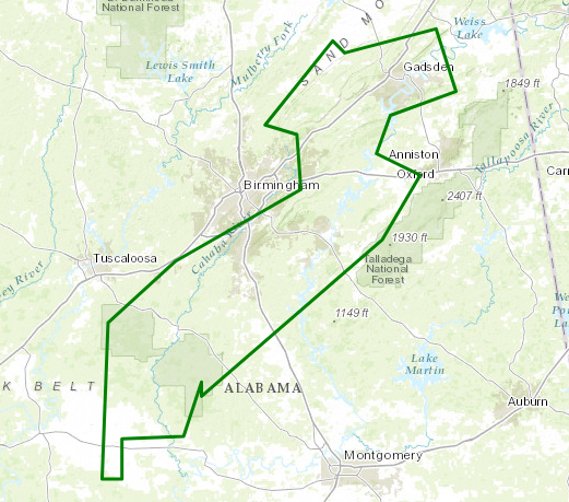
Talladega AL-Chilton AL-Blount AL-Shelby AL-Perry AL-Hale AL-Bibb AL-
Etowah AL-St. Clair AL-
331 PM CDT FRI JUN 23 2017
The National Weather Service in Birmingham has issued a
* Urban and Small Stream Flood Advisory for Poor Drainage Areas
for…
Talladega County in east central Alabama…
Western Chilton County in Alabama…
Southeastern Blount County in Alabama…
Shelby County in Alabama…
Perry County in Alabama…
Northeastern Hale County in west central Alabama…
Bibb County in Alabama…
Etowah County in northeastern Alabama…
St. Clair County in Alabama…
* Until 630 PM CDT
* At 330 PM CDT, Doppler radar indicated heavy rain due to showers
and a few thunderstorms. This will cause urban and small stream
flooding. Overflowing poor drainage areas will result in minor
flooding in the advisory area. An inch of rain will fall in a
short period if time on already saturated ground.
* Some locations that will experience flooding include…
Birmingham, Hoover, Gadsden, Alabaster, Bessemer, Pelham, Helena,
Talladega, Sylacauga, Pell City, Leeds, Moody, Calera, Chelsea,
Rainbow City, Oneonta, Montevallo, Childersburg, Brent and Hokes
Bluff.
PRECAUTIONARY/PREPAREDNESS ACTIONS…
Keep children away from storm drains, culverts, creeks and streams.
Water levels can rise rapidly and sweep children away.
Excessive runoff from heavy rainfall will cause flooding of small
creeks and streams, country roads, farmland, and other low lying
spots.
About the Author (Author Profile)
Scott Martin is an operational meteorologist, professional graphic artist, musician, husband, and father. Not only is Scott a member of the National Weather Association, but he is also the Central Alabama Chapter of the NWA president. Scott is also the co-founder of Racecast Weather, which provides forecasts for many racing series across the USA. He also supplies forecasts for the BassMaster Elite Series events including the BassMaster Classic.Subscribe
If you enjoyed this article, subscribe to receive more just like it.


