

Heavy Rain, Storms Across Parts of Central Alabama
Moderate to heavy rain is occurring across parts of the area this morning. On top of the rainfall many areas received yesterday, this is causing some minor flood concerns.
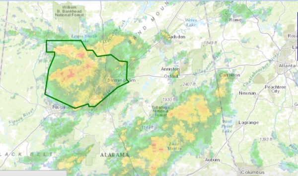
An areal flood advisory was issued a short time ago for parts of Jefferson, Walker, Fayette and Tuscaloosa Counties.
Radar estimates show widespread 2-3 inch amounts have fallen across parts of Tuscaloosa, Fayette and Walker Counties since yesterday, with around 1-1.5 inches across Jefferson County.
With additional rainfall rates of 1-1.5 inches per hour across the advisory area with some extreme amounts of over two inches per hour over Walker County, minor flooding can be expected on roadways and in low lying areas. Be careful and take your time this morning.
Additional showers are forming over Pickens, Lamar and Tuscaloosa Counties, which could mean additional heavy rains moving across the area, including Birmingham, which could make the minor flooding more serious. We will be monitoring.
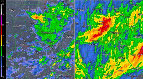
There is a good bit of lightning also in northeastern Walker County in the Sumiton, Sipsey and Cordova areas. This activity will move into the I-65 Corridor in northern Jefferson County and southern Blount County from Colony to Warrior to Kimberly. It is also where the heaviest rain is falling.
To the south, more rain continues from Marion and Selma to Sylacauga to Wetumpka to Roanoke. Not much if any lightning associated with this area of precipitation.
Category: Alabama's Weather, ALL POSTS
About the Author (Author Profile)
Bill Murray is the President of The Weather Factory. He is the site's official weather historian and a weekend forecaster. He also anchors the site's severe weather coverage. Bill Murray is the proud holder of National Weather Association Digital Seal #0001 @wxhistorianSubscribe
If you enjoyed this article, subscribe to receive more just like it.


