

2 pm Radar Update: Showers/Storms NW Alabama, Eastern Mississippi
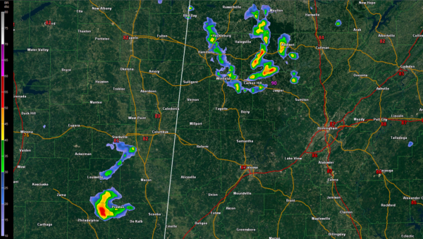
Well, our tandem disturbances are both producing showers at this hour. The lead disturbance over Northwest Alabama is bringing heavy downpours to parts of Fayette, Walker, Marion, Winston, southern Franklin and southern Lawrence Counties.
No lightning with this set of showers yet, but it is only a matter of time. In fact, the cell southwest of Arley in Winston County already has tops over 30,000 so sufficient charge separation for lightning can’t be far away. This activity will lift into Cullman and Morgan Counties over the next 30 minutes. They will eventually impact Blount County as they move more east than northeast.
The other is over eastern Mississippi northeast of Philadelphia. It does have lightning already with tops over 40,000 feet. It will impact parts of Sumter County around 3 p.m. or shortly thereafter.
The storms are growing in intensity and coverage. While they don’t have as much instability and moisture to work with as those of the past few days, they do have some midlevel dry air that makes them candidates for damaging winds. Not really expecting severe weather, but can’t rule out a few damaging wind gusts this afternoon from the stronger storms.
Always watch out for lightning, especially with lots of activities outdoors and on the water today.
Category: Alabama's Weather, ALL POSTS
About the Author (Author Profile)
Bill Murray is the President of The Weather Factory. He is the site's official weather historian and a weekend forecaster. He also anchors the site's severe weather coverage. Bill Murray is the proud holder of National Weather Association Digital Seal #0001 @wxhistorianSubscribe
If you enjoyed this article, subscribe to receive more just like it.


