

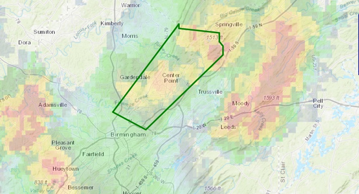
Areal Flood Advisory for Northeastern Jefferson County Until 4:30 p.m.
Heavy rain from Roebuck and Huffman through the Center Point area has the potential to cause minor flooding over the next couple of hours.
Please don’t drive or walk into flood waters. Remember: TURN AROUND, DON’T DROWN!!!
The National Weather Service in Birmingham has issued a
* Urban and Small Stream Flood Advisory for…
Northeastern Jefferson County in Alabama…
* Until 430 PM CDT
* At 135 PM CDT, Doppler radar indicated heavy rain due to
thunderstorms. This will cause urban and small stream flooding in
the advisory area.
* Some locations that will experience flooding include…
Birmingham, Trussville, Gardendale, Fultondale, Pinson-Clay-chalkv,
Center Point, Clay, Pinson, Tarrant, Argo, Ketona Lakes,
Chalkville, Grayson Valley, Birmingham Airport, Palmerdale, Village
Springs, New Castle, Danville and Cloverdale.
PRECAUTIONARY/PREPAREDNESS ACTIONS…
Turn around, don’t drown when encountering flooded roads. Most flood
deaths occur in vehicles.
Excessive runoff from heavy rainfall will cause flooding of small
creeks and streams, urban areas, highways, streets and underpasses as
well as other drainage areas and low lying spots.
Category: ALL POSTS
About the Author (Author Profile)
Bill Murray is the President of The Weather Factory. He is the site's official weather historian and a weekend forecaster. He also anchors the site's severe weather coverage. Bill Murray is the proud holder of National Weather Association Digital Seal #0001 @wxhistorianSubscribe
If you enjoyed this article, subscribe to receive more just like it.


