

An Unstable Airmass At Midday, Marginal Risk For Severe Storms Today
Radar Check At 12:55 PM
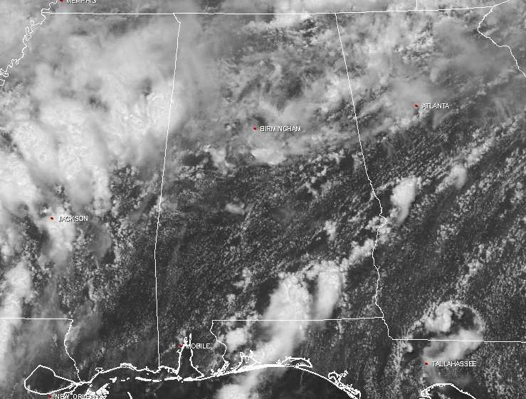
We have a pretty unstable airmass across the area today, thanks in part to an approaching cold front and an approaching shortwave trough. For the northern half of the state, we have mostly cloudy skies with an occasional sunbeam or two reaching the surface. In the southern half, skies are generally mostly clear.
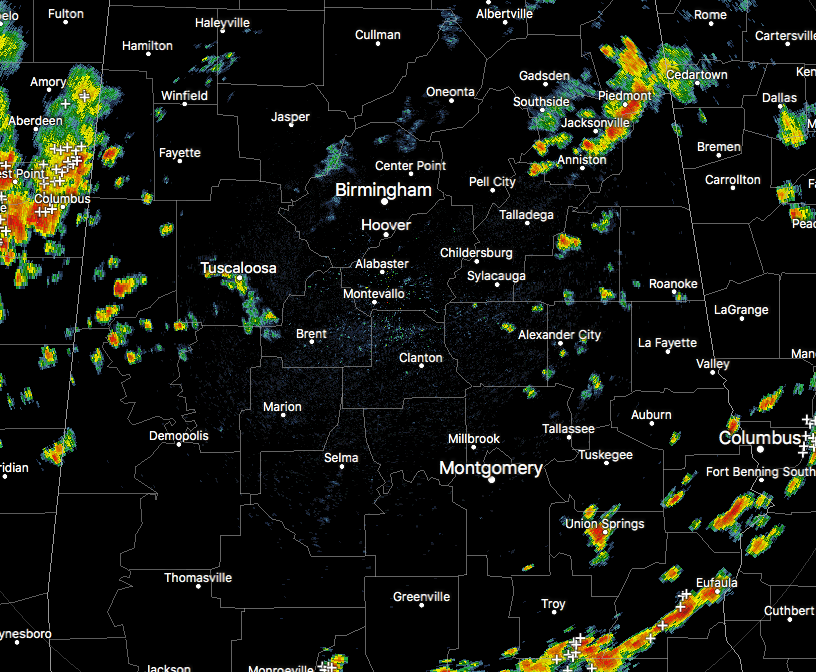
As far as rainfall at this moment, radar is showing several areas of showers and thunderstorms moving in the general east-northeast direction. A big batch of storms is currently pushing into Lamar County and soon into Pickens County from eastern Mississippi. There is a general concern for the possibility of flash flooding with these storms due to heavy rainfall and training of cells over the same area.
Another area of showers is affecting portions of Etowah, Cherokee, Calhoun, and Cleburne counties. These are putting down some heavy downpours and some ponding may be occurring. The good news is that there is no lightning at this point, but that could change in an instant.
And the third batch of storms is located in the southeastern parts of Central Alabama, mainly over portions of Pike, Barbour, and Bullock counties. Heavy rain and dangerous lightning are occurring with these, so please go indoors until these pass you by.
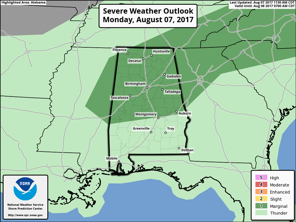
SPC has all of North Alabama and nearly all of Central Alabama defined in a Marginal Risk for severe storms throughout the remainder of the day. The main threat will be from damaging thunderstorm downdraft winds. The window for strong to severe storms will be from now until 10:00 PM tonight.
For The Rest Of Your Monday
We’ll continue to have an increased risk for scattered to numerous showers and thunderstorms throughout the remainder of the day and through the late night and overnight hours. Some of these storms could be strong to marginally severe, especially from now until 10:00 PM tonight. We could have some flash flooding issues over the northwestern locations of the area due to the possibility of rain training over the same areas, and totals could amount to 2-4 inches. The rest of Central Alabama should see around 1/2-inch to 1-inch totals. Afternoon highs will range throughout the 80s today across the area, with lows in the lower to mid-70s.
Tuesday’s Forecast… Grab the Umbrellas And Galoshes
For tomorrow, the cold front will have made it to the southern parts of Central Alabama, and this will continue the increased risk for scattered to numerous showers and thunderstorms, especially for the central parts of the area nearest to the front. Rainfall totals are not projected to be as high as they are today, but 1/2 to 1-inch totals may be possible. Severe weather will not be a threat for Tuesday. Afternoon highs will be in the lower to mid-80s for nearly everyone in Central Alabama, with warmer temperatures in the southeastern portion of the area.
Got Beach Plans?
A decent amount of sunshine each day, but with a good chance of a daily shower or thunderstorm this week. You can expect to see highs mainly in the middle to upper 80s and lows in the 70s. For a detailed look at the weather from Fort Morgan over to Panama City Beach, click here to see the AlabamaWx Beach Forecast Center page.
The Beach Forecast is partially underwritten by the support of Brett/Robinson Vacation Rentals in Gulf Shores and Orange Beach. Click here to see Brett/Robinson’s “Own Your Summer” specials now!
Taking A Peek At The Tropics
Stay up-to-date with “The Latest On The Tropics…” running post in the Tropical Weather category on the AlabamaWx Weather Blog home page.
Advertise With Us!
Now is the time to set your marketing campaign on AlabamaWX. The site has enjoyed a 71% jump in page views this year! The website has already enjoyed 10,157,915 page views this year. We can customize a creative, flexible and affordable package that will suit your organization’s needs. Contact Bill Murray at (205) 687-0782.
E-Forecast
Get the AlabamaWx seven-day forecast delivered directly to your inbox by email twice daily. It is the most detailed weather forecast available in Central Alabama. Click here to subscribe. It’s free!
Today In Weather History
August 7, 1904 – A flash flood near Pueblo, CO, washed a train from the tracks killing 89 passengers. A bridge, weakened by the floodwaters sweeping through the valley below, gave way under the weight of the train dashing all but the sleeping cars into the torrent drowning the occupants. Rail service was frequently interrupted in the Rocky Mountain Region and southwestern U.S. that summer due to numerous heavy downpours which washed out the railroad beds delaying trains as much as five days.
WeatherBrains
Check out the show at www.WeatherBrains.com. You can also subscribe on iTunes. You can watch the show live at live.bigbrainsmedia.com on Monday nights starting at 8:30 PM CDT. You will be able to see the show on the James Spann 24×7 weather channel on cable or directly over the air on the dot 2 feed.
Category: Alabama's Weather, ALL POSTS
About the Author (Author Profile)
Scott Martin is an operational meteorologist, professional graphic artist, musician, husband, and father. Not only is Scott a member of the National Weather Association, but he is also the Central Alabama Chapter of the NWA president. Scott is also the co-founder of Racecast Weather, which provides forecasts for many racing series across the USA. He also supplies forecasts for the BassMaster Elite Series events including the BassMaster Classic.Subscribe
If you enjoyed this article, subscribe to receive more just like it.


