

Strong Storms Affecting Sumter County
SIGNIFICANT WEATHER ADVISORY FOR SOUTHWESTERN SUMTER COUNTY UNTIL 3:45 PM CDT
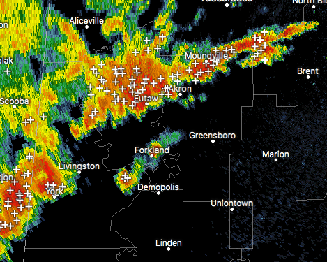
At 3:19 PM CDT, Doppler radar was tracking a strong thunderstorm near Lauderdale, moving northeast at 15 mph. Winds in excess of 40 mph will be possible with this storm.
Locations impacted include Livingston, York, Cuba, Bluffport, Boyd, The University Of West Alabama, Old Mallard Airport, I-20 Welcome Center At Cuba and Payneville.
Torrential rainfall is also occurring with this storm, and may lead to localized flooding. Do not drive your vehicle through flooded roadways. Frequent cloud to ground lightning is occurring with this storm. Lightning can strike 10 miles away from a thunderstorm. Seek a safe shelter inside a building or vehicle.
Category: Archived Warnings
About the Author (Author Profile)
Scott Martin is an operational meteorologist, professional graphic artist, musician, husband, and father. Not only is Scott a member of the National Weather Association, but he is also the Central Alabama Chapter of the NWA president. Scott is also the co-founder of Racecast Weather, which provides forecasts for many racing series across the USA. He also supplies forecasts for the BassMaster Elite Series events including the BassMaster Classic.Subscribe
If you enjoyed this article, subscribe to receive more just like it.


