

Only A Few Showers Out There At Midday, But More Are Expected
Weather Check at 11:00 AM
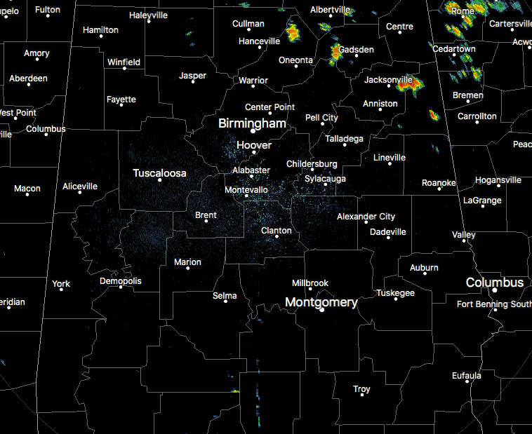
Currently, on radar across Central Alabama, we have a few widely scattered showers over the northeastern parts of the area, mainly over parts of Blount, Etowah, Cleburne, and Calhoun counties. The rest of the area is actually pretty quiet, but that is expected to change as you will see later on in this forecast.
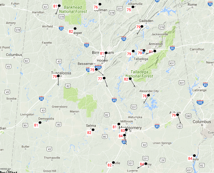
Temperatures across the area at this time are running in the mid-70s to the mid-80s. Birmingham is currently at 81º. A few locations are tied as the warm spot at 84º, while Cullman is the cool spot at 76º.
Today’s Almanac For Birmingham
Sunrise: 6:02 AM … Sunset: 7:38 PM
Normal High: 91º … Normal Low: 71º
Record Maximum High: 102º (2007) … Record Minimum High: 80º (2001)
Record Maximum Low: 79º (2010) … Record Minimum Low: 60º (1953)
Normal Daily Rainfall: 0.13 in … Record Daily Rainfall: 1.89 in (2015)
For The Rest Of Your Thursday
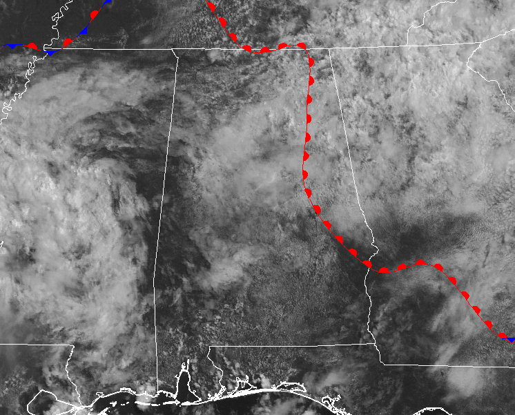
There is an approaching mesocyclone vortex (MCV) that is currently causing convection over Mississippi that will move into the southwestern parts of Central Alabama this afternoon. With our precipitable water values above 2 inches, heavy showers and storms can be expected with the possibility of some localized ponding and flash flooding. This zone could merge with the sea breeze convection and lift northward.
There are other factors that will aid in the development of showers and storms across much of the rest of the area, including lift from an old surface boundary that is moving out of the state. We may have a few stronger storms that develop this afternoon with microburst winds that could reach 40 MPH, but the overall risk for severe storms is very low considering the moist air aloft. Afternoon highs will be in the mid to upper 80s.
Activity should begin to diminish somewhat from west to east later this evening and into the overnight hours as drier air moves in behind the MCV. Rain chances will remain highest in the southeastern parts of Central Alabama. Overnight lows will be in the lower to mid-70s.

Friday’s Forecast… Keep The Umbrellas Handy
A different day but the same result… Friday will be mostly cloudy to completely overcast throughout the day with an increased risk for scattered to numerous showers and thunderstorms across Central Alabama. It will not be a complete all-day rain out, but you can expect rain at some point during the day. Afternoon highs are expected to be in the upper 80s to 90º, but temperatures could remain cooler if decent rain falls in your area.

The Storm Prediction Center has the northwestern part of the state defined in a Marginal Risk for severe storms throughout tomorrow, with the main window for that possibility during the afternoon and early evening hours. The main risks will be from thunderstorm wind gusts and some small hail. Just remember with our saturated soil situation, trees can easily fall even with less than severe wind gusts. We’ll keep you updated on the blog.
Got Beach Plans?
A decent chance of showers and thunderstorms each day through Wednesday, with highs in the upper 80s and lows in the 70s. For a detailed look at the weather from Fort Morgan over to Panama City Beach, click here to see the AlabamaWx Beach Forecast Center page.
The Beach Forecast is partially underwritten by the support of Brett/Robinson Vacation Rentals in Gulf Shores and Orange Beach. Click here to see Brett/Robinson’s “Own Your Summer” specials now!
Taking A Peek At The Tropics
Stay up-to-date with “The Latest On The Tropics…” running post in the Tropical Weather category on the AlabamaWx Weather Blog home page.
Advertise With Us!
Now is the time to set your marketing campaign on AlabamaWX. The site has enjoyed a 71% jump in page views this year! The website has already enjoyed 10,157,915 page views this year. We can customize a creative, flexible and affordable package that will suit your organization’s needs. Contact Bill Murray at (205) 687-0782.
E-Forecast
Get the AlabamaWx seven-day forecast delivered directly to your inbox by email twice daily. It is the most detailed weather forecast available in Central Alabama. Click here to subscribe. It’s free!
Today In Weather History
August 10, 1980 – Hurricane Allen came ashore above Brownsville, TX, dropping fifteen inches of rain near San Antonio, and up to 20 inches in the Lower Rio Grande Valley. Tidal flooding occurred along the South Texas coast. Hurricane Allen packed winds to 150 mph, and also spawned twenty-nine tornadoes. Total damage from the storm was estimated at 750 million dollars.
WeatherBrains
Check out the show at www.WeatherBrains.com. You can also subscribe on iTunes. You can watch the show live at live.bigbrainsmedia.com on Monday nights starting at 8:30 PM CDT. You will be able to see the show on the James Spann 24×7 weather channel on cable or directly over the air on the dot 2 feed.
Category: Alabama's Weather, ALL POSTS
About the Author (Author Profile)
Scott Martin is an operational meteorologist, professional graphic artist, musician, husband, and father. Not only is Scott a member of the National Weather Association, but he is also the Central Alabama Chapter of the NWA president. Scott is also the co-founder of Racecast Weather, which provides forecasts for many racing series across the USA. He also supplies forecasts for the BassMaster Elite Series events including the BassMaster Classic.Subscribe
If you enjoyed this article, subscribe to receive more just like it.


