

The Latest on the Alabama Severe Weather Threat for This Afternoon and Evening
RISK UPGRADED
Forecast confidence is increasing that the threat of tornadoes, including strong tornadoes, and very large hail, perhaps to the size of tennis balls, as well as damaging winds is very real for this afternoon and evening across North and North Central Alabama.
The SPC and the NWS Birmingham have both upgraded their threat ratings to moderate (level 4 of 5) across the northern part of the area.
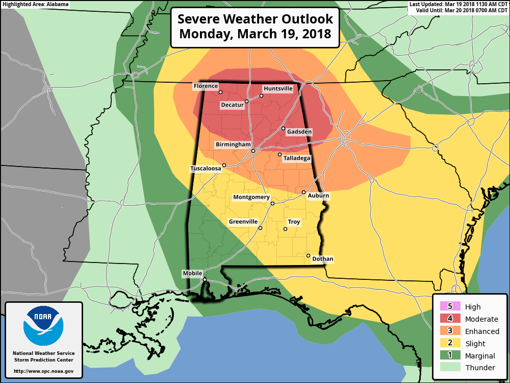
The NWS Birmingham delineates the highest threat from Lamar across Fayette, Jefferson, St. Clair, Blount, Calhoun and Cleburne Counties and points north, including Hamilton, Jasper, Birmingham, Anniston and Gadsden. They have an enhanced risk (level 3 out of 5) across areas including Tuscaloosa, Clanton, Alex City and Auburn. A slight risk (level 2 of 5) extends to the south.
The SPC risk is slightly different, but don’t get hung up on threat levels or colors on maps. Storms don’t pay attention to those. We are all under threat through the evening hours here in North and Central Alabama.
CURRENT CONDITIONS
The warm front has made its way northward and is knocking on the door of the I-20 corridor in Central Alabama. Dewpoints have risen to the mid-60s just south of the interstate. Sylacauga, Calera, and Tuscaloosa have dewpoint readings at 66 degrees as of 11:10 AM, well in that range for severe thunderstorm development.
A huge thunderstorm is moving through the northern portions of northeastern Mississippi at this time with very heavy rain, quarter size hail, and dangerous lightning. A Severe Thunderstorm Warning is in effect for this storm until 12:00 PM, and will start to move into Lauderdale and Colbert counties by that time.
As far as Central Alabama, all is quiet at this time on radar, with some shower activity showing up along and north of the Tennessee River in the northwestern corner of the state. There are a few breaks in the clouds that are allowing surface temperatures to climb quickly. Tuscaloosa was already at 73 degrees at 11:10 AM.
TIMING
The risk of severe weather timing has been shifted to 4-8 pm over the northwestern parts of the area, 6-10 pm in the Demopolis, Tuscaloosa, Clanton, Birmingham, Anniston and Gadsden areas and 9 pm – 2 am in places like Montgomery, Alex City, Auburn, Troy and Eufaula.
Our convection allowing models are coming into decent focus. The highest threat will begin over Northwest Alabama around 4 p.m. That will be about the time the storms are edging into the state.
By 7 p.m., the storms will extend from west of Huntsville through Winston County and into Fayette and Lamar Counties. These storms will be accessing air that could have significant tornado parameters from 2-5, which is very worrisome. STP of 1 is enough for strong tornadoes and higher numbers show a higher threat.
By 10 p.m., the storms should be just southeast of I-59. This would put them into the Tuscaloosa area between 7-9 pm, Birmingham/Gadsden between 9 and 11 pm and Anniston between 10 pm – midnight.
ZEROING IN ON THE THREAT
The NAM 3km is the most aggressive and worrisome model, with CAPEs near 2500 j/kg, and 0-1 km SRH of 297 m2/s2 at 7 p.m. just northwest of Birmingham. This yields a significant tornado parameter of 6.5. Lapse rates are near 7 c/km, and hail parameters show significant threat of very large hail.
Category: Alabama's Weather, ALL POSTS
About the Author (Author Profile)
Bill Murray is the President of The Weather Factory. He is the site's official weather historian and a weekend forecaster. He also anchors the site's severe weather coverage. Bill Murray is the proud holder of National Weather Association Digital Seal #0001 @wxhistorianSubscribe
If you enjoyed this article, subscribe to receive more just like it.


