1:45 a.m. Update
The National Weather Service in Jackson just canceled the only severe thunderstorm warning that was still in effect across their area, state, in fact the country.
It was for Webster County, which is northwest of Starkville. The warning was for the apex of that MCV storm complex that developed over Central Louisiana last evening and has been moving northeast ever since.
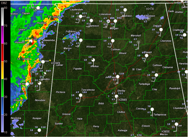
Just before 1:30, the line of storms was approaching Tupelo and Starkville, or about an hour west of Marion, Lamar and Pickens Counties in West Alabama. You can pick out a bit of an “S” signature in the radar echoes, which is indicative of the potential for damaging winds. There is a surface low there somewhere near Tupelo, which would concern us if there was more instability.
There was a report of trees down on Highway 17 in Carroll County MS about 12:08 a.m. This storm would prompt the Webster County warning.
But the lack of any Doppler data indicating damaging winds and the lack of reports of damage allowed the Weather Service to cancel the warning before it expired.
The storms will reach Jasper and Tuscaloosa by 3:30 and Cullman/Bessemer by 4:30. Birmingham should see them by 5 or so. This timing is a little faster than anticipated earlier.
The storms could still flare as they move into West Alabama, so we will be watching them closely. There is about 500 j/kg of CAPE over West Alabama that the storms will continue to be able to tap. And there are stronger winds aloft now moving into northwestern Mississippi which could help the storms intensify a bit through the early morning hours.
We will have updates as anything changes. 5
Category: Alabama's Weather, Severe Weather


