Christmas Eve Update
I hope you and your family are enjoying a peaceful Christmas Eve. Parameters are still coming together for a high impact severe weather threat for Alabama tomorrow…
You can watch Brian’s morning Weather Xtreme video for a meteorological discussion of tomorrow’s threat.
Below are the SPC severe weather outlook maps for tomorrow and tomorrow night…
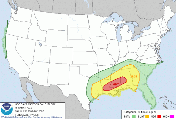
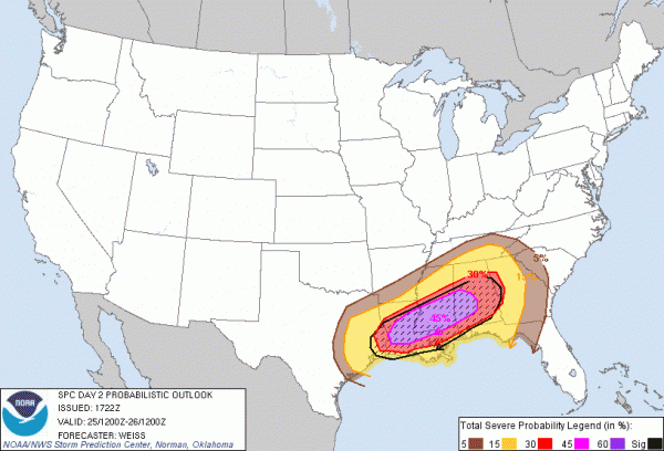
Note the “hatched” are on the second map; that means there is a 10% or greater probability of significant severe weather within 25 miles of a point. And, SPC defines “significant severe weather” as F2 or greater tornadoes, damaging winds with speeds greater than 65 knots, or large hail 2″ or greater in diameter. The “hatched” area runs from Southeast Texas to West Georgia, and includes basically all of North-Central Alabama.
But we stress the severe weather risk includes ALL of Alabama.
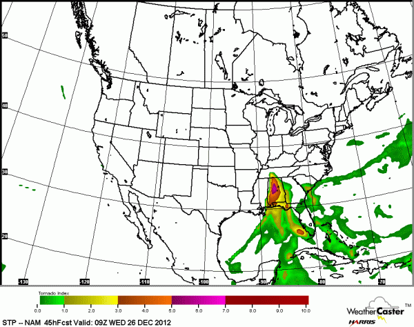
See the STP (Significant Tornado Parameter) index tomorrow night, as projected by the NAM model…
WHAT TO EXPECT: Storms tomorrow afternoon and tomorrow night could produce hail, damaging wind, and tornadoes. Considering the atmospheric setup, a few strong/violent tornadoes are possible, especially south of I-59/20, and west of I-65. But again, the risk of severe weather is statewide. Doesn’t make much sense to ask about any specific county, town, or neighborhood in this case.
TIMING: While severe storms could develop in West Alabama as early as 3:00 tomorrow afternoon, the primary threat will come from 4 p.m. tomorrow until 3 a.m. Wednesday.
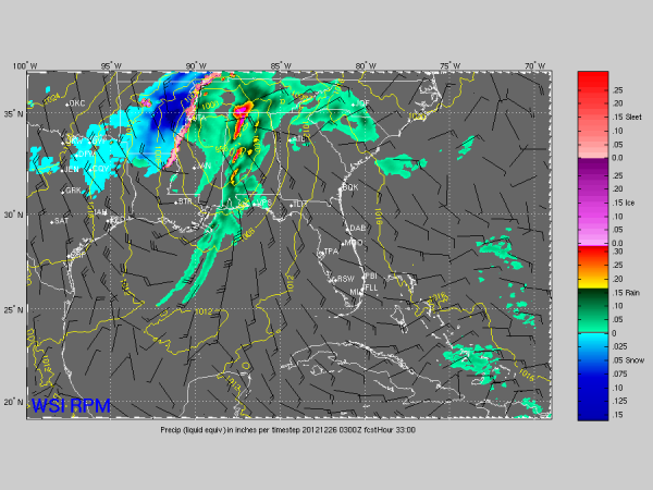
Below is the RPM model output, valid at 9:00 CST tomorrow night…
TRAVEL: If it all possible, we recommend that travel tomorrow across any part of Alabama will come before 3:00. If you have to travel by car after 3:00, be sure you have a good source of getting severe weather warnings. And, remember, many radio stations could be “unmanned” tomorrow. You can always hear ABC 33/40 audio during our long form coverage on your smart phone via the ABC 33/40 app.
SNOW TO THE NORTH AND WEST: If you are traveling, here is the latest snow projection on this storm system from the NAM…
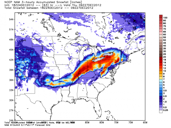
This will be a whopper of a snow storm in the cold air north and west of the surface low. And, here in Alabama, Wednesday will be cold and raw with falling temperatures. Some light snow, or snow flurries, are possible over the northern counties, but accumulation is not expected.
CALL TO ACTION: This is a challenging outbreak because it falls on Christmas Day. Many will be traveling, and we won’t be able to reach people effectively. First off, since many people aren’t as connected to the weather as you, please pass this along to your friends, neighbors, and anybody else you come in contact with today so they will be aware of the situation.
BE ABLE TO RECIVE WARNINGS: Never, never, never rely on an outdoor siren to let you know a tornado is coming. That is dangerous, and no telling how many Alabamians have been killed by this “siren mentality” over the years. They reach a limited number of people outdoors, and that is it. The baseline is having a NOAA Weather Radio in your home, properly programmed, and with fresh batteries in case of a power failure. Also, having a good smart phone warning app is even better. We recommend iMap WeatherRadio for iPhone and Android phones, and MyWarn for iPhone. Both will warn you ONLY if you are in a warning polygon (remember, warnings are not county based), you can program in fixed locations, and most importantly, you can watch live ABC 33/40 severe weather coverage within the app.
You can also watch our live tornado coverage on the web here.
Yes, I am very active on social media, but remember on Facebook you won’t see all posts coming from me within your newsfeed unless you subscribe to my regular account (NOT friend request… subscribe) and choose to receive all updates from me. Here are all my social media accounts…
KNOW WHERE TO GO: If you live in a mobile home and you are in a tornado warning polygon, you must leave. Remember, tomorrow is Christmas and many typical safe places will be closed. Think about it and be ready. And, if you live in a site built home, the safe place is a small room on the lowest floor, away from windows, and near the center of the home. Have readiness kit that includes helmets for everybody in the house, flashlights, extra batteries, shoes, medication, etc.
Again, please do NOT be alarmed by this threat. Enjoy today and tomorrow with your family and don’t worry. But, be aware of the threat and have a way of getting the warnings, and have a plan, and we will all be fine. Stay tuned to be blog for running updates…
Category: Alabama's Weather, Severe Weather
About the Author (Author Profile)
James Spann is one of the most recognized and trusted television meteorologists in the industry. He holds the AMS CCM designation and television seals from the AMS and NWA. He is a past winner of the Broadcast Meteorologist of the Year from both professional organizations.Subscribe
If you enjoyed this article, subscribe to receive more just like it.


