

New Day 1 Outlook Is Out
The Storm Prediction Center issues the new Day One Severe Weather Outlook for the coming day between midnight and 1 a.m. CST. It goes into effect at 12:00 GMT, which is 6 a.m. CST.
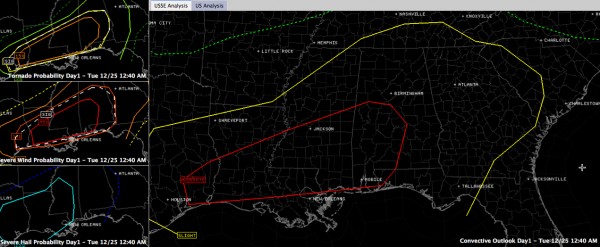
The entire state of Alabama is in the slight risk area, the standard severe weather forecast issued by the SPC.
There is a rare moderate risk area (rare for any month, let alone December) that goes from east of Houston to near Tuscaloosa, Clanton, Montgomery and east of Greenville, AL.
You can see the slight and moderate risk areas in the graphic’s larger panel. Click on the graphic to bring it up in separate page and there you can click on it to enlarge.
There is a 15% probability of a tornado area all the way north to Jasper, Birmingham and Anniston. This area is hatched, meaning the SPC forecaster believes that is a 10% or greater chance that there will be an EF2 or higher tornado within 25 miles of any point in the hatched area.
There is a very high (45%) probability of damaging winds in the moderate risk area, up to Tuscaloosa, Clanton and Montgomery. There is a hatched area for winds of 70 mph all the way up to Hamilton, Cullman and Jacksonville AL.
No real change in the thinking late tonight. Strong upper level disturbance diving out of Colorado early this morning that will spin up strong surface low pressure that will move east northeast toward Mississippi by tonight.
An unstable air mass will develop behind a northward moving warm front tomorrow. With very high wind shear, supercell thunderstorms are expected to develop by early to mid-afternoon over Southwest Alabama. These will develop northeastward during the late afternoon and evening.
Then a powerful line of thunderstorms will move through the area overnight.
Now is the time to review your severe weather safety plan and make sure that you have a reliable source for receiving polygon warnings from the National Weather Service.
This is a developing weather situation that all Alabamians must pay close attention to for the next 24 hours.
Category: Alabama's Weather, Severe Weather
About the Author (Author Profile)
Bill Murray is the President of The Weather Factory. He is the site's official weather historian and a weekend forecaster. He also anchors the site's severe weather coverage. Bill Murray is the proud holder of National Weather Association Digital Seal #0001 @wxhistorianSubscribe
If you enjoyed this article, subscribe to receive more just like it.


