Being Negative Can Put You in the Cold
If you were paying any attention to the weather this week, you would have noticed the bitterly cold arctic air that impacted portions of the Northern U.S. Temperatures were so cold and some areas that school had to be cancelled. Overnight lows were in the negative 30s below zero, with wind chills in the negative 50s. Some of the coldest temperatures in the region in more than five years. You may have asked, why we didn’t receive much of this cold air mass into Alabama, and why what we did receive was only short-lived for a couple of days? Maybe I can shed some light for you here.
One of the ways we forecast significant cold weather outbreaks, is by using Teleconnections. Teleconnections are large climate anomalies that occur all over the world. Even the computer models look at these Teleconnections when outputting forecasts. Teleconnections most commonly refer to pressure difference between two set locations over a a large area. For example, the ENSO, El Nino Southern Oscillation is one most people are familiar with. When there is a change in the ENSO, which has to do with pressure difference between the island of Tahiti and Darwin, Australia in the Southern Hemisphere. When this switches it will affect weather patterns. We have these Teleconnections all over the world and look at them at different times of the year.
During the winter time, one way we can forecast a large scale arctic air outbreak in the Eastern United States is by looking at two Teleconnections to our north and east. The first is the Arctic Oscillation, AO and the other is the NAO, North Atlantic Oscillation. We measure these oscillations by whether they are positive or negative.
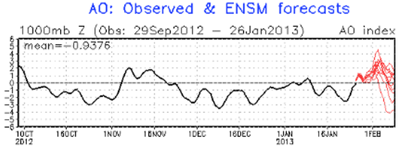
The Arctic Oscillation, is a pattern in which pressure over the polar regions varies in opposition with that over the middle latitudes on times scales ranging from weeks to decades. The high index is defined as periods of below normal sea level pressure in the arctic, enhanced westerlies in the north Atlantic, and warmer and wetter than normal conditions in northern Europe.
The negative phase is associated with blocking in the arctic which allows cold, arctic air to spill south into the mid-latitudes. When the AO is negative, temperatures on average are several degrees cooler than normal over most of the U.S., Northern Europe, Russia, China and Japan. When this happens many cities like Birmingham, Paris & Tokyo have their coldest temperatures. Looking at the current AO, you will notice that it has been negative this last week, thus allowing for the Arctic outbreak across the Midwest and Great Lakes where many locations were below zero.
The NAO, is a large scale seesaw in atmospheric mass between the Bermuda High in the Central Atlantic Ocean and the Icelandic polar low. When the NAO is positive, it means that there is a stronger than normal subtropical high and a deeper than normal Icelandic low. The increase in pressure gradient produces an increase in the frequency and strength of winter storms crossing the Atlantic on a more northerly track. When this happens, Europe experiences warm and wet winters while it is cold and dry over Northern Canada and the Eastern Half of the U.S. has mild and wet conditions.
When the NAO is negative, the pressure gradient is less, meaning fewer and weaker winter storms crossing the Atlantic. A high can be located over Greenland, which means we have blocking. This prevents the cold air from moving off the continent and crossing the Atlantic. When this happens the Eastern U.S. receives more arctic outbreaks and more snowy conditions. Currently, the NAO is positive but has been slightly negative earlier this week
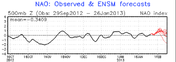
The most important thing to remember when looking at these two teleconnections during the winter time, is to see whether or not they are both negative and not just slightly negative, but a deep negative phase in both. When this occurs, expect cold arctic air to invade the U.S. and instead of moving out quickly, blocking over the North Atlantic will prevent it from moving out like it usually will. This will cause wave after wave of cold air to dam back up into the U.S. This would allow for a persistent and cold arctic air outbreak. The black lines represent actual observations of each oscillation. The red lines on these graphs are some of the model ensembles forecast, and if some of these forecast outliers were to be completely accurate, it would appear that by mid February, both oscillations could be very negative and that would allow for very cold air to move in to the U.S. This is just the forecast of what these oscillations may be doing and just another of many things we look at when forecasting.
In conclusion, for the cold air earlier this week, the AO was very negative, but the NAO was not. There was no blocking to our east and the cold air was able to move off the continent and out in to the Atlantic. Therefore allowing temperatures to moderate as we headed through the week.
Additionally, we just don’t look at these teleconnections during the winter time, but throughout the year. For example, the NAO is key in forecasting the amount of possible tropical activity in the Atlantic during hurricane season.
Category: Alabama's Weather
About the Author (Author Profile)
Macon, Georgia Television Chief Meteorologist, Birmingham native, and long time Contributor on AlabamaWX. Stormchaser. I did not choose Weather, it chose Me. College Football Fanatic. @Ryan_StinnetSubscribe
If you enjoyed this article, subscribe to receive more just like it.


