Tropics and Alabama Weather Update
The tropics are getting a little more interesting as we head deeper into July. Here is an update:
DISTURBANCE 94L: The trough of low pressure over the western Gulf of Mexico shows no signs of organization at this time and it is not expected to become a depression.
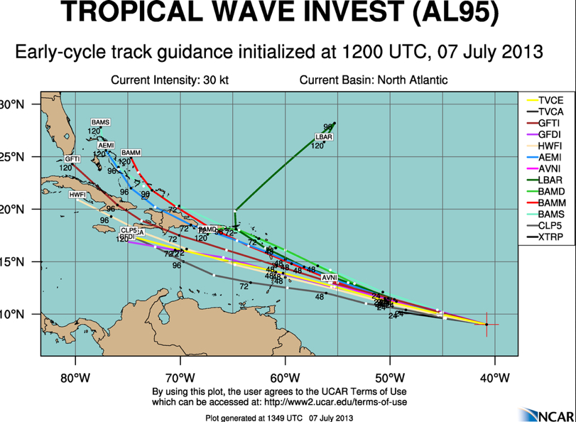
DISTURBANCE 95L: There is a strong tropical wave about 1350 miles east southeast of the Windward Islands today. It has shown signs of organization but has not developed a closed circulation yet. It should cross the southernmost Windward Islands Monday night and emerge into the eastern Caribbean on Tuesday. Most of the guidance thinks it will be a tropical storm.
If so, it will be named Chantal. In any case, this system will bring squally weather to the islands of Guadeloupe, Dominica, Martinique, Saint Lucia, Saint Vincent and Barbados by late Monday into Tuesday.
It then will likely take a track near the Greater Antilles (Hispaniola, Cuba) by late in the week. Here are some of the models’ forecasts for the system:
It could then affect anywhere from the eastern Gulf of Mexico, the Florida Panhandle or the southeastern coast of the U.S. next weekend. Could Candace be another Dennis from 2005? Remember, it made landfall at Navarre Beach in the Panhandle as a Category Three hurricane.;
SEASON COUNT: So far, two tropical storms have formed in the Atlantic Basin. Andrea moved inland in the Florida Big Bend area on June 6th as a strong tropical storm (top winds 65mph). Tropical Storm Barry formed over the southwestern Caribbean on June 17th, moved across the Yucatan and grew into a Tropical Storm over the Bay of Campeche. It made landfall near with winds of 45 mph near Veracruz on the 20th.
QUICK CENTRAL ALABAMA NOWCAST:
Showers continue from Dallas through Autauga, southern Chilton, Coosa, Clay, Tallapoosa and Randolph Counties, extending southward into the LaGrange and Opelika areas. This activity is moving northeast, but the entire area is pushing slowly eastward as drier air filters into Alabama.
Showers over Southwest Alabama in Clarke County were moving into Marengo County. This activity is on a track that could impact Central Alabama, but it should also be shunted east and southeast eventually by the drying. It could impact areas as far north as Clanton, but the Birmingham area should be protected from it.
Scattered showers could form late this morning in the I-20 corridor and lift northward, but they should be in the Tennessee Valley by mid-afternoon, leaving things dry in the Tuscaloosa, Birmingham, Gadsden and Anniston areas. Can’t rule out a stray shower or storm, but the chances appear to have come down a bit this afternoon.
There could be a few scattered showers through the overnight hours and there will be some on Monday as well. Tuesday will finally feel like a more typical summer day, with just scattered PM storms and highs in the upper 80s.
Category: Alabama's Weather, Tropical
About the Author (Author Profile)
Bill Murray is the President of The Weather Factory. He is the site's official weather historian and a weekend forecaster. He also anchors the site's severe weather coverage. Bill Murray is the proud holder of National Weather Association Digital Seal #0001 @wxhistorianSubscribe
If you enjoyed this article, subscribe to receive more just like it.


