

Coldest Air In Ten Years Early Next Week
An all new edition of the ABC 33/40 Weather Xtreme video is available in the player on the right sidebar of the blog. You can subscribe to the Weather Xtreme video on iTunes by clicking here.
WET START: Rain is falling early this morning over much of Alabama ahead of a deep upper trough and strong surface cold front. Temperatures are in the 40s, so the air is stable and there are no thunderstorms involved.
The rain will end from west to east during the midday hours, and temperatures will fall into the 30s this afternoon with a strong northwest wind of 15-25 mph. There might be a snow flake in the colder air somewhere over North Alabama late today, but the deeper moisture will be long gone as the really cold air arrives.
FRIGID FRIDAY: We will reach the mid to upper teens early tomorrow; the NAM is printing a low of 16 for Birmingham. We will still have a northwest wind of around 10 mph at the time, and that will push the wind chill index down to near zero early tomorrow morning. On the positive side, the sky will be clear and the day will be sunny, but we won’t get past the mid 30s. Some communities north of Birmingham won’t make it past the freezing mark tomorrow afternoon.
BRIEF WEEKEND WARM-UP: Saturday will be the best day to do something outdoors this weekend; the sky will be sunny, and after a low around 20 degrees, we will warm up into the 47 to 50 degree range by afternoon.
Low 50s are possible Sunday, but the sky will be cloudy, and rain showers are likely Sunday ahead of an Arctic cold front that will bring bitterly cold air down into Alabama.
LONG DURATION SUB-FREEZING PERIOD: Temperatures will drop below freezing around 8:00 p.m. Sunday, and I don’t think we (North-Central Alabama) will rise above freezing until around 10:00 a.m. Wednesday. That is 62 consecutive hours below freezing.
Let’s break it down in chronological order…
SUNDAY NIGHT SNOW POTENTIAL: Temperatures will fall rapidly following the front, and there is a chance the rain will change over to snow before ending. Yes, there is a chance there could be dusting of snow Sunday night over North/Central Alabama, but the snow will move out pretty quickly during the pre-dawn hours Monday, and with strong northwest winds of 15-25 mph, I honestly don’t expect this to be a really big issue. We will keep an eye on model trends in coming days, however.
MONDAY: We will start the day in the upper teens, and see a high only in the upper 20s. Strong northwest winds of 12-25 mph will push the wind chill index below zero at times. A few light snow flurries are possible, but the cold air is the big deal.
TUESDAY: Temperatures will bottom out at daybreak Tuesday. The 00Z GFS MOS (model output statistics) is now printing a low of 9 degrees at Birmingham. As I have shared here before, it is very hard to see single digit lows here with no snow cover, but there will be a pretty decent snow pack to the north, meaning there won’t be much modification of the Arctic air. We will forecast a median low of 10 degrees early Tuesday… some places north of Alabama could very well see a single digit low.
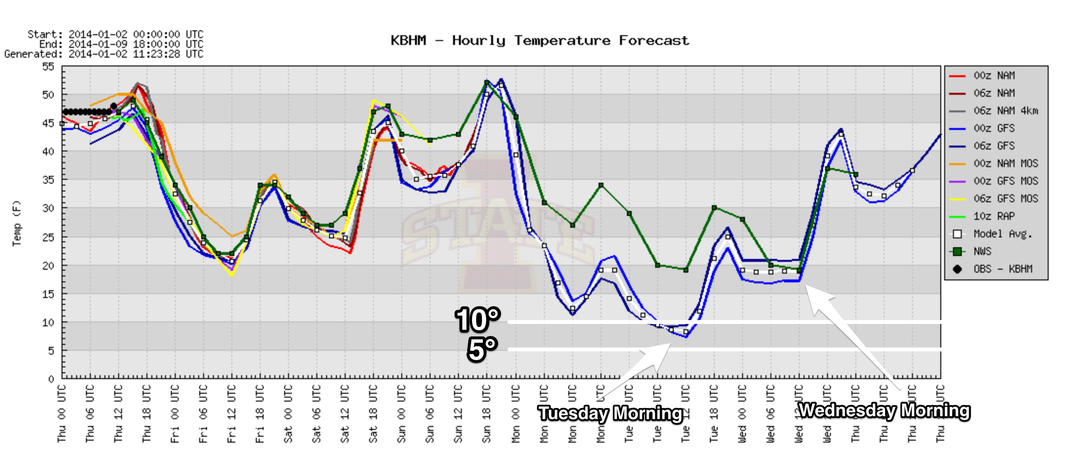
Tuesday will be sunny but cold with a high in the mid to upper 20s. The wind won’t be as strong, so wind chill index values won’t be as low as Monday.
WEDNESDAY: I still think we have potential to see a low between 10 and 15 degrees early Wednesday, although model guidance isn’t quite a cold. It will be a good setup for radiational cooling with a clear sky and light wind. Then, finally, a warming trend begins Wednesday afternoon as we rise into the 40s with a sunny sky.
COLDEST IN TEN YEARS: Here is a look at the coldest temperature in Birmingham over the past several years…
2013 18 (November 28)
2012 20 (February 12)
2011 16 (January 13 and January 14)
2010 14 (January 5 and January 11)
2009 12 (January 16)
2008 13 (January 3)
As far as I can tell from a quick database analysis, the last time Birmingham had a single digit low was on January 24, 2003 when our low was 7 degrees. If we reach 10 degrees early Tuesday, it will our coldest morning since that cold day ten years ago.
SUGAR BOWL WEATHER: For tonight’s Alabama/Oklahoma football game in New Orleans (7:30p CT kickoff), we can safely promise no rain since the game is indoors (the Louisiana Superdome)… outside the rain should end by mid-morning; temperatures in New Orleans will fall into the 40s this afternoon.
BCS NATIONAL CHAMPIONSHIP WEATHER: For now it looks like routine southern California weather for Auburn fans making the trip out west. No rain for the next 7 days at Pasadena, CA; highs are in the 70s, with lows between 47 and 52. Lots of sun.
BBVA COMPASS BOWL: A perfect day for football in Birmingham Saturday, when Vanderbilt and Houston match up at 12:00 noon. Lots of sun; the kickoff temperature will be near 42 degrees, rising to near 50 by the final whistle. No risk of rain.
WEATHER BRAINS: Don’t forget you can listen to our weekly 90 minute netcast anytime on the web, or on iTunes. This is the show all about weather featuring many familiar voices, including our meteorologists here at ABC 33/40.
CONNECT: You can find me on all of the major social networks…
Facebook
Twitter
Google Plus
Instagram
Look for the next Weather Xtreme video here by 4:00 or so this afternoon. Enjoy the day…
Category: Alabama's Weather
About the Author (Author Profile)
James Spann is one of the most recognized and trusted television meteorologists in the industry. He holds the AMS CCM designation and television seals from the AMS and NWA. He is a past winner of the Broadcast Meteorologist of the Year from both professional organizations.Subscribe
If you enjoyed this article, subscribe to receive more just like it.


