Bitter Cold; South Alabama Winter Storm Ahead
An all new edition of the ABC 33/40 Weather Xtreme video is available in the player on the right sidebar of the blog. You can subscribe to the Weather Xtreme video on iTunes by clicking here.
WINTER STORM WARNING FOR SOUTH ALABAMA: The National Weather Service has issued a Winter Storm Warning for much of South Alabama for tomorrow and tomorrow night… south of a line from Demopolis to Billingsley to Alexander City to Lafayette. Just to the north, a “Winter Weather Advisory” is up for Greene, Hale, Sumter, Chilton, Clay, Coosa, Perry, and Randolph Counties.
Our overall thinking has not changed much at all…
Here are the important points you need to know…
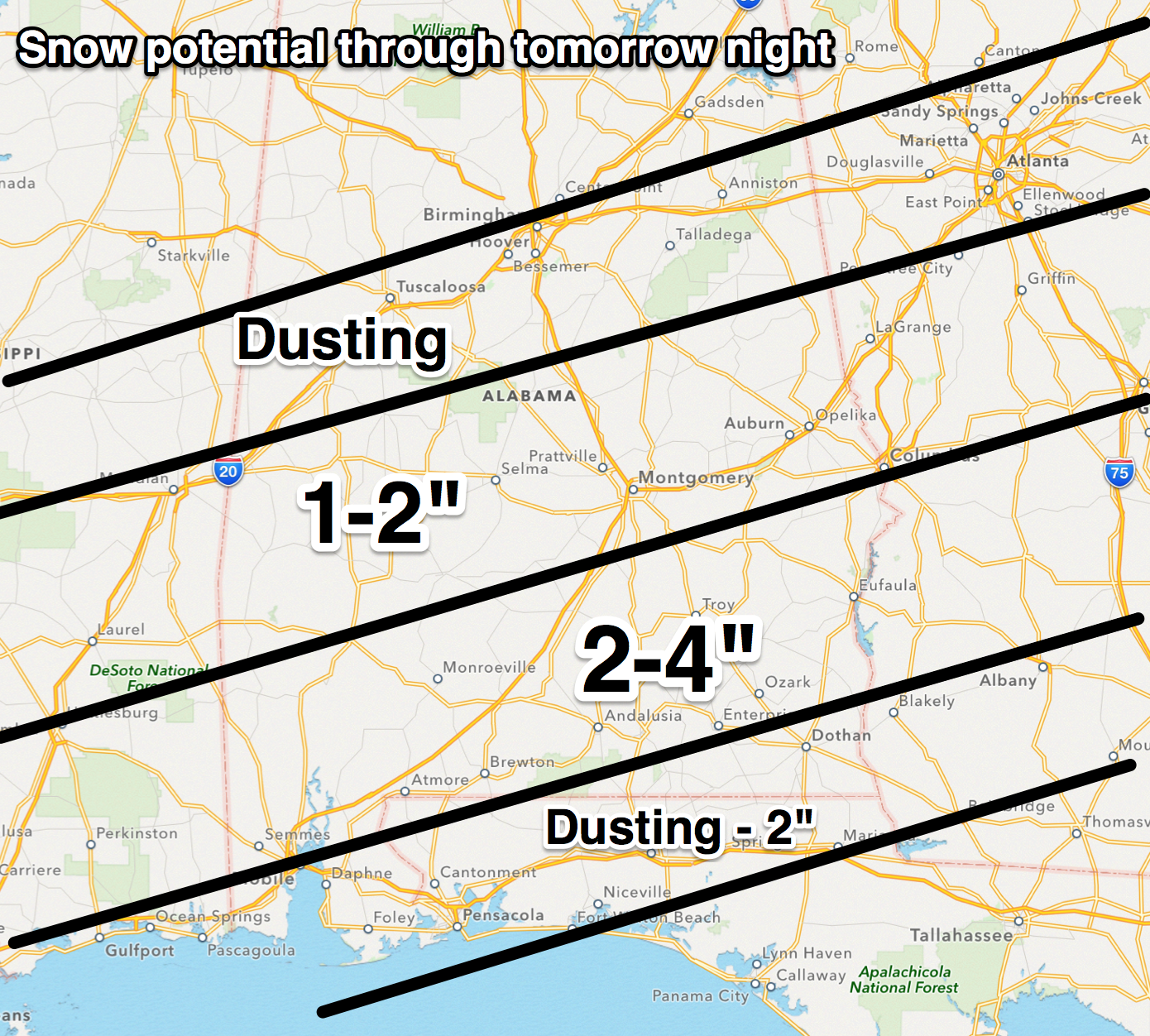
*Light snow could break out across Alabama early tomorrow morning. Yes, we do expect snow in places like Birmingham, Tuscaloosa, Anniston, and Gadsden, but generally it should be very light and scattered, and no significant accumulation is expected. Maybe a dusting in a few spots. Travel issues are not expected through North/Central Alabama.
*Over the southern half of the state, precipitation begins tomorrow. Near the coast, it begins as rain and sleet, with a change over to freezing rain and sleet, and snow by tomorrow night. Driving conditions should deteriorate late tomorrow afternoon initially with bridge icing, and by tomorrow night travel will be very difficult across the southern counties of Alabama, especially south of U.S. 80. Bridges and overpasses will become very icy.
*A period of freezing rain is likely in many South Alabama communities before the snow begins with some ice accumulation. This will make for very dangerous driving conditions, but the ice load is not expected to be high enough for power outages.
*Higher snow amounts should be in the broad area from Montgomery down to Troy and over to Eufaula and Phenix City, where some 4 inch totals are possible.
*Mobile could see one inch of snow, but they will have to deal with sleet and freezing rain before it changes over. Bridge icing is possible all the way down to the Gulf Coast late tomorrow night and early Wednesday.
*Remember, we don’t have much experience in forecasting winter weather events in South Alabama, so expect a few surprises along the way. Some will be delighted with the snow amounts they get, others severely disappointed.
ARCTIC COLD: ALL of Alabama will be in the deep freeze through mid-week. For North/Central Alabama, we will have a hard time getting out of the low 30s tomorrow and Wednesday; the coldest mornings will come early Wednesday and Thursday. The low at daybreak Wednesday will be in the 8 to 13 degree range, with 10 to 15 degrees likely early Thursday. The sky becomes sunny Wednesday, and Thursday will be sunny as well. We begin to warm up Thursday afternoon with a high in the 40s.
FRIDAY AND THE WEEKEND: Friday will be dry with a partly sunny sky and a high in the 50s. Then, for the weekend, Saturday promises to be mild and showery with occasional showers possible. The day will be mild with a high in the 60s. The 12Z GFS brings in drier air early Sunday morning, hinting much of the day Sunday could be rain-free. See the Weather Xtreme video for the maps, graphics, and details of longer range weather.
WEATHER BRAINS: Don’t forget you can listen to our weekly 90 minute netcast anytime on the web, or on iTunes. This is the show all about weather featuring many familiar voices, including our meteorologists here at ABC 33/40. We will produce tonight’s show at 8:30p CT… you can watch it on “James Spann 24/7” on cable systems around Alabama, and on the web here.
CONNECT: You can find me on all of the major social networks…
Facebook
Twitter
Google Plus
Instagram
I had a great time today visiting with the first graders at Vestavia Hills Elementary Cahaba Heights… look for them on the Pepsi KIDCAM today at 5:00 on ABC 33/40 News! The next Weather Xtreme video will be posted here by 7:00 a.m. tomorrow…
Category: Alabama's Weather
About the Author (Author Profile)
James Spann is one of the most recognized and trusted television meteorologists in the industry. He holds the AMS CCM designation and television seals from the AMS and NWA. He is a past winner of the Broadcast Meteorologist of the Year from both professional organizations.Subscribe
If you enjoyed this article, subscribe to receive more just like it.


