Notes to our North and West
A MAJOR WINTER STORM WILL IMPACT MUCH OF THE UNITED STATES INCLUDING THE MID-SOUTH TONIGHT AND MONDAY
The NWS in Birmingham was posted a freezing rain advisory for the northwestern parts of Central Alabama from 4-9 a.m. tomorrow morning for a glaze of ice that could accumulate from light freezing rain and freezing drizzle early tomorrow morning. The advisory includes Marion, Winston, Walker, Fayette and Lamar Counties.
For areas north of this, the National Weather Service in Huntsville has posted a winter weather advisory for Colbert, Lauderale, Franklin, Lawrence and Limestone Counties for early tomorrow morning.
IMPORTANT NOTE
Early this afternoon, the NWS Huntsville added Madison and Jackson Counties to the winter weather advisory for the Tennessee Valley.
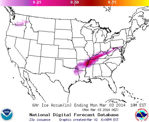
Here is the worst ice accumulation through midnight tonight:
Here is a rundown of information from National Weather Service offices to our north and west. We will keep this running blog post updated through the evening hours.
LATE REPORTS
…6:38: Friend of the WeatherBrains show, Eric Proseus reports 1.79″ of rain in the CoCoRaHS gauge at 3N Bartlett as of 5 mins ago. 33.0 degrees and steady rain w/ lightning right now. Light icing on all exposed objects, under 0.10″.
NWS JACKSON
…The northern part of the Delta could see 0.25-0.40 inches of ice, including Greenville and Greenwood.
…The southern part of the Delta, including Yazoo City, 0.1-0.2 inches of ice could accumulate.
…Up to an inch of snow possible over the northern part of the Delta in Mississippi.
NWS MEMPHIS
…Freezing rain rates will be approaching 0.10-0.25″ per hour this evening over western Tennessee.
…1/2 to 3/4 of an inch of ice in the Memhis area (including the Mississippi suburbs) and two inches of snow.
…1-3 inches of snow expected across northwestern Tennessee.
…Up to four inches of snow across eastern Arakansas and southeastern Missouri.
…Rain starting to freeze on exposed surfaces around Jackson TN just before 6 p.m.
…1/4″ of ice and 1″ of sleet in Dyersburg.
NWS NASHVILLE
…Winter storm warnings in effect through Monday morning for much of Middle Tennessee.
…One half to one inch of ice accumulation is expected in places like Clarksville and Waverly.
…1/4 to 1/2 inch from Waynesboro, to Columbia to Nashville.
…The current balloon release from Nashville shows a significant warm layer that is 8500 feet deep. The surface temperature is approaching freezing. This will lead to serious freezing rain.
…2-3 inches of snow is expected near the Kentucky border as the airmass cools further and the precip changes to all snow.
…Nashville is expecting an inch of snow.
…A winter weather advisory is in effect for places like Manchester, Cookeville and Crossville, where up to one quarter of an inch of ice accumulation is expected.
NWS PADUCAH/LOUSIVILLE
…Serious icing is expected tonight over Kentucky.
…Winter storm warnings are in effect for the entire state including ice storm warnings for the southwestern part of the state around Hopkinsville and Madisonville.
…Ice accumulations should reach one half inch in the ice storm warning area.
…Elsewhere one quarter of an inch of ice is likely.
…The freezing rain may turn to heavy sleet later this evening as temperatures drop well into the 20s.
NWS MORRISTOWN TN
…Significant icing in eastern Tennessee and southwestern Virginia
…1/4 to 1/2 inch of ice and 1-3 inches of snow across this region.
Category: Alabama's Weather, Headlines, Winter Weather
About the Author (Author Profile)
Bill Murray is the President of The Weather Factory. He is the site's official weather historian and a weekend forecaster. He also anchors the site's severe weather coverage. Bill Murray is the proud holder of National Weather Association Digital Seal #0001 @wxhistorianSubscribe
If you enjoyed this article, subscribe to receive more just like it.


