

Beautiful Spring Day
An all new edition of the ABC 33/40 Weather Xtreme video is available in the player on the right sidebar of the blog. You can subscribe to the Weather Xtreme video on iTunes by clicking here.
DRY AIR TAKES OVER: The NWS in Birmingham has issued a “dense fog advisory” for much of Central Alabama this morning, but that fog will burn off quickly, and the day ahead will be delightful with sunshine in full supply along with a high in the upper 70s. The humidity will be low as dewpoints drop into the 30s.
We stay dry tomorrow; a partly sunny sky with a high up in the low 80s. It could be the warmest day so far this year for some Alabama communities.
We do note the standard “slight risk” of severe weather tomorrow from Memphis down to Shreveport, but the storms there will weaken considerably late tomorrow night as they approach and the upper support lifts out.
FRIDAY: A band of weakening showers and storms will move into Northwest Alabama late tomorrow night around midnight, and they will continue to fizzle as they move deeper into the state. Some North Alabama communities could see some rain during the pre-dawn hours Friday, but by sunrise most of the showers will be over.
The daytime hours Friday will be mostly dry with a mix of sun and clouds; the weather stays warm with a high at or just over 80 degrees.
THE ALABAMA WEEKEND: It will clearly be the warmest weekend so far this year; the GFS is suggesting highs will be up in the mid 80s both Saturday and Sunday. There will be sufficient moisture and instability for a few isolated showers both days, mostly during the afternoon and evening hours, but the chance of any one spot getting wet will be only about one in eight.
TO THE WEST: A significant severe weather outbreak will unfold across the South-Central U.S. over the weekend as a vigorous upper trough moves out of the Rockies, and a very deep surface low forms over East Colorado (983 mb). This system will encounter high to extreme instability over parts of North Texas and the Southern Plains, and all modes of severe weather will be possible. Sunday seems to be the day when severe weather parameters are maximized to the west. This is the SPC convective outlook…
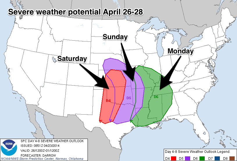
ALABAMA EARLY NEXT WEEK: As you can see the “Day 6” severe weather risk extends well into Alabama. It is important to understand we can’t be too specific about the severe weather threat six days in advance; you will hear lots of rumors floating around, but the skill in identifying mesoscale features that determine the magnitude of a severe weather threat this far out is small.
A sub-1000 mb surface low is forecast to be near St. Louis late Monday night, with a deep, negative tilt upper trough over the Great Plains. The 00Z GFS suggests the primary window for thunderstorms in Alabama will come from about 9:00 p.m. Monday through 12:00 noon Tuesday.
The good news is that the model is showing lower surface based instability values (under 750 j/kg) when the storms arrive late Monday night and early Tuesday, but the bulk shear values are very high, and the low level jet is strong (over 60 knots).
No doubt severe weather will be likely across Alabama late Monday night into Tuesday morning, with all modes of severe weather possible, but again I stress it is impossible to go into more detail this early in the game. Take a few minutes to watch the Weather Xtreme video to see all of the maps, graphics.
LATER NEXT WEEK: After the severe weather, much colder air invades Alabama Wednesday as a deep upper trough forms over the eastern U.S. Sure looks like we won’t make it out of the 50s Wednesday afternoon with lingering clouds, and some of the colder pockets over Northeast Alabama might make a run at lows in the upper 30s by Thursday or Friday morning.
AT THE BEACH: Expect mostly sunny days and fair nights tomorrow through the weekend from Panama City over to Gulf Shores. A few isolated showers could show up Friday and Saturday, but the chance of any one spot seeing rain is small. Highs along the immediate coast will be in the 68-72 degree range because of the cooler ocean water; but just a few miles inland highs will rise into the low to mid 80s. Sea water temperatures remain in the mid 60s.
WEATHER RADIO TOUR: We will be at the Publix in the McCalla/Bessemer area (just off I-459 exit one) today from 3:30 until 6:30 p.m. If you need your weather radio programmed, or have questions, or need to buy one, come see us. The Birmingham weather radio transmitter is off the air due to equipment failure, and the NWS indicates it might be 10 days or so before it gets back on the air. We can answer questions about this as well, and reprogram your radio for other frequencies that might work in your location.
WEATHER BRAINS: Don’t forget you can listen to our weekly 90 minute netcast anytime on the web, or on iTunes. This is the show all about weather featuring many familiar voices, including our meteorologists here at ABC 33/40.
CONNECT: You can find me on all of the major social networks…
Facebook
Twitter
Google Plus
Instagram
I have a weather program this morning at Hokes Bluff Middle School… look for the next Weather Xtreme video here by 3:00 this afternoon. Enjoy the day….
Category: Alabama's Weather
About the Author (Author Profile)
James Spann is one of the most recognized and trusted television meteorologists in the industry. He holds the AMS CCM designation and television seals from the AMS and NWA. He is a past winner of the Broadcast Meteorologist of the Year from both professional organizations.Subscribe
If you enjoyed this article, subscribe to receive more just like it.


