Dry Through The Weekend; Stormy Next Week
An all new edition of the ABC 33/40 Weather Xtreme video is available in the player on the right sidebar of the blog. You can subscribe to the Weather Xtreme video on iTunes by clicking here.
RADAR CHECK: All is quiet across the great state of Alabama this morning… the pre-dawn showers have dissipated, and drier air will work into the state in coming hours. Today will be mostly sunny with a high in the mid to upper 70s.
WARM WEEKEND: Look for the warmest weather so far this year over the weekend; mid 80s are likely tomorrow and Sunday. The sky will be mostly sunny both days, although high clouds begin to move in Sunday afternoon.
A significant severe weather outbreak is likely Sunday west of Alabama, with a “moderate risk” up already for the Ark-La-Tex region.
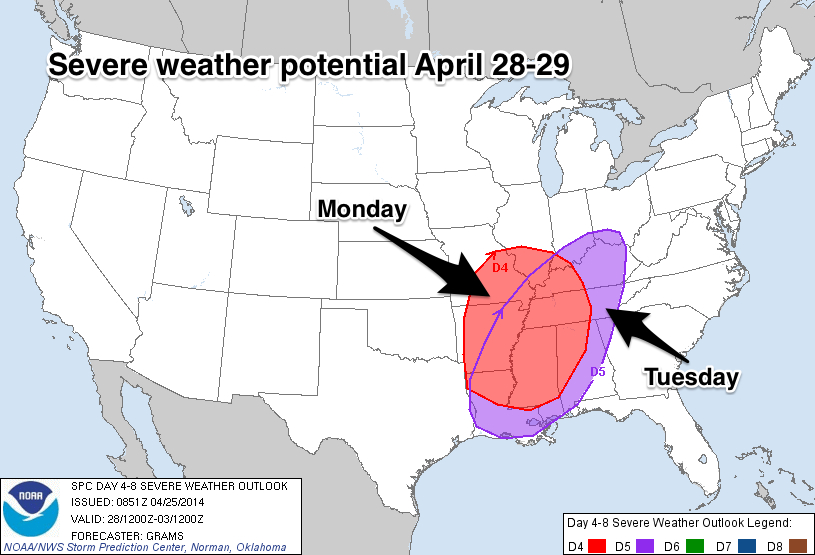
VERY ACTIVE WEATHER EARLY NEXT WEEK: We have the dual threat of severe thunderstorms and flash flooding for the first half of next week. SPC has North and West Alabama in a severe weather threat Monday, and a large part of the state in a risk Tuesday.
Clearly, there will be multiple rounds of strong to severe storms and heavy rain Monday, Tuesday, and even Wednesday.
TIMING: This is almost impossible due to the complex nature of the large scale upper trough west of the state and the vorticity lobes rotating around the trough (like spokes on a wheel). The first round of storms is likely over North and West Alabama Monday and Monday night, with other rounds to come Tuesday, Tuesday night, and Wednesday. Each MCS (mesoscale convective system) has the potential to lay down small scale boundaries that can serve as a focus for the next round of storms, and identifying how this all plays out several days in advance is really not possible. Just be ready for several rounds of storms during the first half of next week.
I would suggest the severe weather parameters will be maximized for Alabama Tuesday and Tuesday night, but I sure can’t rule out severe storms Monday and even on Wednesday.
Understand there will be good breaks in the rain/storms, but storms could fire at just about any time during these three days.
THREATS: All modes of severe weather will be possible, including large hail, damaging straight line winds, and a few tornadoes.
FLOODING: This is a very real possibility. The ECMWF (European model) tries to bring some 8 inch rain totals to Central Alabama by Wednesday, with amounts of 3 to 4 inches likely in most places. This could lead to some significant flooding problems, especially by Tuesday and Wednesday. People in flood prone areas will need to pay attention to flash flood warnings if they are needed.
IS THIS LIKE APRIL 27, 2011? As I wrote here yesterday, I don’t answer that question since it just takes one tornado coming down your street to make it YOUR April 27. You need to be ready for every severe weather threat. Events like April 27, 2011 are generational… they happen in our state about every 40 years.
BIRMINGHAM NOAA WEATHER RADIO: The Birmingham transmitter is back on the air (162.55 MHz), but the coverage is a bit lower than you get under normal circumstances. Test warnings will be sent (on the Birmingham frequency only) today and tomorrow at 11:00 a.m. and 6:00 p.m. We suggest a “layered approach” when it comes to receiving severe weather warnings, you need multiple ways. A good smart phone app like MyWarn or iMap WeatherRadio is a must-have in Alabama during severe weather season.
AT THE BEACH: Look for sunny days and fair nights through Monday… showers and storms return Tuesday and Wednesday of next week. Highs on the immediate coast will be in the low 70s, but 80s are likely just a few miles inland. Sea water temperatures are near 70 degrees.
WEATHER BRAINS: Don’t forget you can listen to our weekly 90 minute netcast anytime on the web, or on iTunes. This is the show all about weather featuring many familiar voices, including our meteorologists here at ABC 33/40.
CONNECT: You can find me on all of the major social networks…
Facebook
Twitter
Google Plus
Instagram
I have weather programs today at Skyland Elementary in Tuscaloosa, and Liberty Park Elementary in Vestavia Hills. Look for the next Weather Xtreme video here by 4:00 this afternoon. Enjoy the day!
Category: Alabama's Weather
About the Author (Author Profile)
James Spann is one of the most recognized and trusted television meteorologists in the industry. He holds the AMS CCM designation and television seals from the AMS and NWA. He is a past winner of the Broadcast Meteorologist of the Year from both professional organizations.Subscribe
If you enjoyed this article, subscribe to receive more just like it.


